- Texas State Highway 255
Infobox TX State Highway
type=State
route=255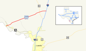
shields=
length_mi=22.451
length_ref=TxDOT|SH|255|accessdate=2008-03-13]
length_round=3
formed=2004
dir1=West
dir2=East
from=United States-Mexico border at theColombia Solidarity International Bridge
junction=
to=jct|state=TX|I|35 north of Laredo
previous_type=State
previous_route=254
next_type=State
next_route=256State Highway 255 or SH 255 is a state-owned toll road bypassing Laredo, stretching from the
Colombia Solidarity International Bridge northeast to Interstate 35 at exit 24.History
The route was originally approved in 1997 as a privately owned toll route for mainly truck traffic to bypass the city of Laredo for traffic congestion. The route was opened as the Camino Colombia Toll Road in October
2000 , costing around $90 million.In August 2001, landowners that were shareholders of the route filed a lawsuit, claiming that profits and traffic usage were less than expected The failure of the route was attributed to the price for truck traffic ($16), the continuation of U.S. government policies banning Mexican trucks from the interior of the United States (which were expected to be abolished under the
North American Free Trade Agreement ), and the approval of a new freeway connecting route from theWorld Trade International Bridge crossing along Loop 20 to Interstate 35.The toll road was foreclosed on late in 2003, and was auctioned off on the steps of the Webb County courthouse
January 6 ,2004 . [cite web|url=http://tollroadsnews.info/artman/publish/article_309.shtml|title=Camino Colombia TR in creditor hands, fate uncertain|accessdate=2008-03-14|date=2004-01-15|publisher=TOLLROADSnews] It was purchased by its main creditor, the John Hancock Life Insurance Company, for the minimum $12 million, 1/6 of the construction value. The only other bidder was the Texas Department of Transportation at $11 million. The route was subsequently closed to all traffic. In May 2004, TxDOT purchased the route from John Hancock for a negotiated $20 million, and reopened the route in September, dropping the toll to $2 toll for cars and $2 per additional axle. [cite web|url=http://tollroadsnews.info/artman/publish/article_649.shtml|title=Camino Colombia TR begins operations under TXDOT|accessdate=2008-03-14|date=2004-09-09|publisher=TOLLROADSnews]Route description
SH 255 begins at the
Colombia Solidarity International Bridge on theUnited States-Mexico border northwest of Laredo in Webb County. It heads northeast from the border as a 4-lane divided highway to an intersection with FM 1472. The highway continues to the northeast as a 4-lane divided highway but merges down to a 2-lane road just west of the toll barrier. SH 255 continues northeast to an intersection at FM 3338 and adiamond interchange with US 83. It continues to the northeast to its eastern terminus at I-35.cite map|publisher=Google Maps |title=Overview map of SH 255|accessdate=2008-03-14|url=http://maps.google.com/maps?f=d&hl=en&geocode=3480571624540148819,27.699868,-99.745313%3B12798883612421464554,27.828930,-99.411319&saddr=FM-255+E+%4027.699868,+-99.745313&daddr=Camino+Colombia+Rd+%4027.828930,+-99.411319&doflg=ptm&sll=27.828939,-99.411845&sspn=0.003022,0.003036&ie=UTF8&ll=27.675015,-99.610291&spn=0.387352,0.388641&z=11]Between 10:00 p.m. and 6:00 a.m., there is no toll collector on duty; traffic using the route between these hours must pay with a route-specific prepaid card. Unlike other TxDOT-operated toll roads, the
TxTag electronic toll collection system is not accepted at present.Junction list
References

Wikimedia Foundation. 2010.