- Herttoniemi
Subdivisions of Helsinki
subdivision_name = Herttoniemi
subdivision_name_swe = Hertonäs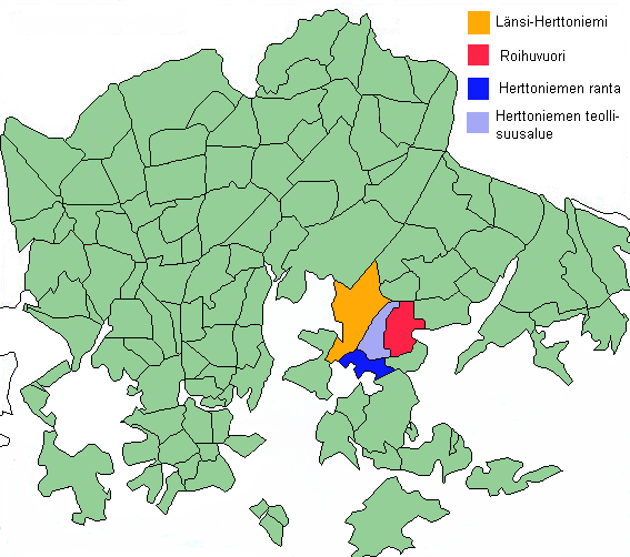
subdivision_number = 43
district = Southeastern
area = 6.06
population = 27,347 (2004)
density = 4,455
postcode = 00800, 00810, 00811, 00820
regions =Länsi-Herttoniemi ,Roihuvuori ,Herttoniemenranta ,Herttoniemen teollisuusalue
neighbours =Itäkeskus Kulosaari Laajasalo Marjaniemi Tammisalo Viikki |Herttoniemi (Swedish: Hertonäs; unofficial English translation based on the historic meaning of the name: "Duke Cape") is a neighbourhood and a suburb of
Helsinki , the Finnish capital. It is located about 7 km east of the city centre and can be easily reached by metro in 10 minutes. It has an older northern suburb and a newer coastal suburb with ferry connections to the city centre. There once was a largeharbour in Herttoniemi, but in the 1990s, this industrial harbour area was demolished and converted to a tightly populated residential area and marina.The Siperia Social Centre, a squatted council house in Herttoniemi, burned down on
14 June ,2006 .There are four districts in Herttoniemi:
*Länsi-Herttoniemi West Herttoniemi
*Roihuvuori which is former East Herttoniemi
*Herttoniemenranta Harbour of Herttoniemi
*Herttoniemi industrial areaFamous people
Swedish military architect
Augustin Ehrensvärd whos life's work was building the fortress ofSveaborg ownedHerttoniemi manor in the area.One of the most famous Finnish writers
Frans Eemil Sillanpää who was awarded theNobel Prize in Literature in 1939 lived in Herttoniemi.ee also
*
Geography of Helsinki
Wikimedia Foundation. 2010.