- Extremadura
Autonomous community
name = Extremadura
full-name = Comunidad Autónoma de Extremadura
coat-of-arms = Escudo de Extremadura.svg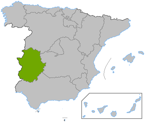
capital = Mérida
language = Spanish;
area = 41,634
area-rank = 5th
area-magnitude =E10
area-percent = 8.2%
pop = 1,083,879
pop-rank = 12th
pop-percent = 2.5%
pop-date = 2005
density = 26.03
english-name = Extremaduran, Extremenian
spanish-name = extremeño/a
autonomy =February 26 ,1983
congress = 10
senate = 2
president =Guillermo Fernández Vara (PSOE)
president-link = List of Presidents of Extremadura
code = EX
website = [http://www.juntaex.es Junta de Extremadura]Extremadura is an autonomous community of western
Spain whose capital city is Mérida. It includes the provinces of Cáceres and Badajoz. Extremadura bordersPortugal to the west, and it is an important area for wildlife, particularly with the major reserve atMonfragüe , which has recently been recognised as a National Park, or the project of InternationalTagus River Natural Park (Parque Natural Rio Tajo internacional). To the north it bordersCastile and León (provinces of Salamanca and Ávila); to the south, it bordersAndalusia (provinces of Huelva, Seville, and Córdoba); and to the east, it bordersCastile-La Mancha (provinces of Toledo and Ciudad Real). In Extremaduran is called EstremauraFact|date=September 2008.Origin of the name
There are various theories about the origins of the name. According to one, the name of Extremadura comes from
Latin "Extrema Dorii" ("The ends of the Duero"), which designates that the territory is situated to the south of the basin of the Duero (and its tributaries). However, another well-respected theory is that the word Extremadura was used generically during theReconquista in order to designate the lands situated on the borders of the Christian kingdoms to the north (in particular, the kingdoms of León and Castile) withAl-Andalus . The Extremadura name would therefore be given to the borderlands of Castile, which later turned to the province of Soria (whose capital's shield says "Soria pura cabeza de Estremadura"), also known as "Extremadura castellana". This should not be confused with the former Portuguese province ofEstremadura , although the etymological origin may be the same.Geography
Extremadura is contained within 37° 57' N, 40° 85' N latitude and 4° 39' W, 7° 33' W longitude.
The
area of Extremadura is 41,633 km², making it the 5th largest of the Spanish autonomous communities.Mountain systems
To the north of Extremadura rise the sierras of the
Sistema Central , composed of theSierra de Gredos , theSierra de Béjar where it reaches its highest altitude in the Calvitero at 2401 m andSierra de Gata which separates Extremadura from Castile.In the center is the
Sierra de las Villuercas and theSierra de San Pedro , which form part of theMontes de Toledo To the south rises the
Sierra Morena which separates Extremadura from Andalusia.Hydrographic network
There are four different hydrographic basins:
* The basin of
Tagus , with two principal tributaries: to the right: theTiétar and the Alagón and to the left: theAlmonte ,Ibor ,Salor and theSever . The tributaries on the right edge carry a large quantity of water, which feed the throats of theSistema Central where the rainfall is abundant and the winter brings a great quantity of snow.
* The basin ofGuadiana , which has principal tributaries: to the right:Guadarranque andRuecas to the left:Zújar which is its plentiful tributary and theMatachel .
* The basin ofGuadalquivir .
* The basin ofDuero Climate
The climate of Extremadura is Mediterranean, except to the north, where it is continentalized , and to the west, where the influence of Atlantic makes the climate milder.
In general, it is characterized by its very hot and dry summers, with great droughts, and its long and mild winters due to the oceanic influence because of its proximity to the Atlantic coast of
Portugal .Temperatures
The average yearly temperature fluctuates between 16 and 17°C year to year. In the north of Extremadura, the average temperatures are lower than those in the south, the values declining as you go southward to the Sierra Morena, where it diminishes from altitude.
During the summer, the average temperature in July is greater than 26 °C, at times reaching 40 °C.
The winters are mild with the lowest temperatures being registered in the mountainous regions, but an average temperature of 7.5 °C.
Population
As of
2006-01-01 , the population of Extremadura is 1,086,373 inhabitants, representing 2.74% of the Spanish population (44,708,964).The population density is very low (25.81 people/km²) if compared to Spain (84.42 people/km²).
The most populated province is that of Badajoz, with a population of 673,474 and a population density of 30.94 people/km². With an area of 21,766 km², it is the largest province in Spain. 412,899 people live in the province of Cáceres, which has an area of 19,868 km², and thus the largest province in Spain after Badajoz's.
The most important urban centers are
Badajoz (143,748 inhabitants),Cáceres (90,218), Mérida (53,915) andPlasencia (39,874).Immigration to Extremadura
In the Extremaduran territory there live 29,068 foreigners, according to the INE census of January 1, 2007, of which 16,647 live in the Province of Badajoz and 12,421 residing in Province of Cáceres. The largest immigrant community is
Moroccan with 9,218 people, followed by the Romanian with 4,324 and then the Portuguese with 3,492 people. Brazilians account for 1,676 and Colombians make up 1,409. Of immigrants fromSub-Saharan Africa , the largest community isSenegalese with 88 people. Of those from Asia, the Chinese make up the largest group with 631 people.Historical development
The Extremaduran population, according to the 1591 census of the provinces of the
Kingdom of Castile , there were around 540,000 people, making up 8% of the total population of Spain. No other census was made until 1717. That year 326,358 people were counted.From this period, the population grew steadily until the 1960s (1,379,072 people in 1960 [INE. Censo 1960. Tomo III. Volúmenes provinciales.] ). After 1960, emigration to more prosperous regions of Spain and Europe drained the population.
Municipalities
Extremadura consists of 383 municipalities, 164 are from the Province of Badajoz and the other 219 are from the Province of Cáceres.
*
List of municipalities in Badajoz
*List of municipalities in Cáceres Languages
The only language that is officially recognized is Spanish, however other languages are also spoken:
*Portuguese, with many varieties: Oliventine Portuguese in
Olivenza , Portuguese ofHerrera de Alcántara , Portuguese ofCedillo , as well as Portuguese ofValencia de Alcántara andLa Codosera . The majority of these varieties of Portuguese are endangered. Some Extremaduran schools teach these as a foreign language, but not usually to the level of fluency.*A Fala, a
Galician-Portuguese language, is a specially protected language and is spoken in the valley ofJálama .*The
Extremaduran language , is related to Leonese [ [http://www.unesco.es] ] and is severely endangered. It is taught neither publicly nor privately.History
Lusitania , an ancient Roman province approximately including current dayPortugal (except for the northern area today known asNorte Region ), and a central western portion of the current day Spain, covered in those times today's Autonomous Community of Extremadura. Mérida (capital of Extremadura), became the capital of the Roman Lusitania province, and one of the most important cities in theRoman Empire .Extremadura was the source of many of the most famous Spanish conquerors ("
conquistador es") and settlers in America.Hernán Cortés ,Francisco Pizarro ,Pedro de Alvarado ,Pedro de Valdivia ,Francisco de Orellana , Pedro Gomez Duran y Chaves andVasco Nunez de Balboa were all born in Extremadura and many towns and cities in America carry a name from their homeland: Mérida is the name of the administrative capital of Extremadura, and also of important cities in Mexico and Venezuela; Medellín is now a little town in Extremadura, but also the name of the second largest city in Colombia;Albuquerque is the largest city in New Mexico and its name is due to a transcription mistake of AlburquerqueFact|date=September 2007, another town in Extremadura. The two (to date) Spanishastronaut s,Miguel López-Alegría andPedro Duque , also have family connections in Extremadura. KingFerdinand II of Aragon died in the village of Madrigalejo,Cáceres in1516 .Pedro de Valdivia founded numerous cities inChile with names from small villages in Extremadura, such as Valdivia andLa Serena . The capitalSantiago de Chile was founded as "Santiago de Nueva Extremadura" (Santiago of New Extremadura).Economy
The Extremadura Regional Government has authored its own
Linux distribution ,gnuLinEx . Following the last board meeting of the Government heldJune 25 ,2006 , the councillor for Infrastructures and Technological Development, Luis Millán de Vázquez de Miguel, [http://lwn.net/Articles/193402/ announced] ( [http://www.regiondigital.com/modulos/mod_periodico/pub/mostrar_noticia.php?id=43131 Spanish] ) that a version of gnuLinEx, adapted for the public administration, will be established as the obligatory operating system in workplaces of the civil servants of the Junta and that theoperating system will be gradually introduced to all administrative organizations of the Junta de Extremadura.Culture
These western Spaniards have some things in common with their Portuguese neighbors to the west.
Each year a bicycle race touring the region takes place. It is called the "Vuelta a Extremadura," and 2008 is its 21st running.
*
Music of Extremadura ee also
*
Estremadura
*Extremaduran language References

Wikimedia Foundation. 2010.