- Churton Park
-
Churton Park Suburb Churton Park City Wellington Island North Island Surrounded By: To the North Tawa To the East Glenside, Newlands, Grenada Village, Paparangi To the South Johnsonville To the West Ohariu Valley, Makara, Tasman Sea Schools Primary Churton Park School Local Intermediates and Colleges Raroa Normal Intermediate, Newlands Intermediate, Onslow College, Newlands College Churton Park is a suburb located 1.5 km north of Johnsonville in the Northern Suburbs district of Wellington, the capital city of New Zealand. It was established in the 1970s, and as of 2009[update] has a population of 6,260 residents.[1]
The suburb includes over 1500 households, 'Churton Park' (a recreational sports field), primary schools (one existing, one under construction), and a kindergarten. A local community center with shops is planned and construction began in February 2011.
The suburb has an active community residents association who meet monthly at the Churton Park School. Along with general community advocacy they organise the annual free community Christmas party and also a car boot fair in March of each year.
Contents
Geography
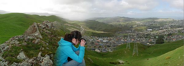
The geography of the land is quite hilly and has dense bush in some areas that have not been excavated for housing sub-divisions. Steep hills eventually extend over to the Ohariu Valley nearby. Many people may use unofficial trails to climb the surrounding hills as a pastime and they are popular among thrill-seeking motorcyclists.
Weather
The micro-climate that is experienced by residents of Churton Park is only slightly different than that of surrounding Johnsonville, but it much warmer and much less windy than Wellington due to its sheltering from the Cook Strait. It rarely snows here, apart from the most recent winter of 2011 which shut down busses and roads breifly and caused some students and workers to stay home for a few days.
Shops
The Churton Park store dairy is located near Churton Drive on Middleton Road.
The nearest mall is Johnsonville Mall in Johnsonville. A new village centre with shops is expected to be built in Churton Park, and construction is expected to get underway in 2011.
A garden shop and a cafe is located on Middelton road in Glenside.
Schools
Churton Park has two state primary schools that cater for pupils up to Year 6. Churton Park School on Churton Drive is an established school. The school's roll has rapidly increased over the years. To accommodate these increases, there have been many renovations to the school's buildings between 1997 and 2007. In 2006, to help manage roll growth, the School Board proposed an amendment to the existing zoning policy/area. This was heatedly debated in the community as the proposal would have removed several long-standing Churton Park streets from the Zone. The associated community concern, protest action and lobbying by the Campaign for Local Schooling and parent feedback resulted in the announcement by the Ministry of Education in 2007 that a new (larger) school site would be developed in the local area.[2] On 17 March 2009, Minister of Education Anne Tolley announced that a second primary school would be built in the area instead.[3]
Amesbury School on Amesbury Drive will open in 2012.[4].
Churton Park also has a little school located on Melksham Drive off Westchester Drive and a kindergarten located next to Churton Park School.
There are no intermediate schools or colleges within the area, so many students attend Raroa Normal Intermediate, Newlands Intermediate Onslow College and Newlands College; all within the local Johnsonville and Newlands area.
Mining
A number of historic gold mining shafts are present within this area. The Tawa Flats All Luck Gold Mining Company of 1881 had shafts in the area including one which is now buried beneath Erlestoke Crescent in Churton Park.[5][6]
Public Transport
Churton Park is serviced by scheduled bus services mainly provided by Mana Coach Services. Route 54 is the primary service that provides direct connection from Churton Park to Johnsonville Hub, Wellington Railway Station and Courtenay Place. There is also a regular bus service north to Tawa and Porirua.
References
- ^ Burgess, Dave (9 June 2009). "New school for 'forgotten suburb'". The Dominion Post. http://www.stuff.co.nz/dominion-post/news/wellington/2483611/New-school-for-forgotten-suburb. Retrieved 10 December 2009.
- ^ "New School for Churton Park". http://www.scoop.co.nz/stories/ED0707/S00024.htm.
- ^ "Media Statement from Minister of Education". http://www.churtonpark.school.nz/Board/newschooldevelopment2009.aspx.
- ^ "Establishment Board appointed for Amesbury Drive School, Churton Park". http://www.minedu.govt.nz/theMinistry/AboutUs/mediaCentreLanding/mediaReleaseIndex/ChurtonParkEstablishmentBoard.aspx.
- ^ "Glenside community". http://www.glenside.wellington.net.nz/index.php/c1869-gold-mine.html.
- ^ "Wellington’s Outer Green Belt Management Plan – April 2004, Wellington City Council". http://www.wellington.govt.nz/haveyoursay/meetings/title/Council/2004/16Jun1730/pdf/5_minutes_appendix_3_part_1_OGBPlanPt2v2.pdf.
External links
Coordinates: 41°12′30″S 174°48′29″E / 41.208355°S 174.80819°E
Categories:- Suburbs of Wellington City
Wikimedia Foundation. 2010.

