- Clackmannanshire Bridge
-
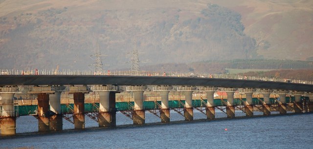
Clackmannanshire Bridge 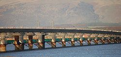
Official name Clackmannanshire Bridge, Scotland Carries Motor vehicles
(A876 road)
Cyclists
(National Cycle Route 1)
PedestriansCrosses Firth of Forth Locale Fife (North bank), Falkirk (South bank) Maintained by Forth Estuary Transport Authority Designer Benaim & WA Fairhurst Design concrete piers and girders Total length 1.2 kilometres (0.75 mi) Width Three lanes of traffic Constructed by Morgan Vinci Opened 19 November 2008 Daily traffic 20,000 vehicles per day Preceded by A91 road Followed by Kincardine Bridge Coordinates 56°04′22″N 3°44′12″W / 56.07285°N 3.736725°WCoordinates: 56°04′22″N 3°44′12″W / 56.07285°N 3.736725°W = 

The Clackmannanshire Bridge is a road bridge over the Firth of Forth in Scotland which opened to traffic on Wednesday 19 November 2008. Prior to 1 October 2008 the bridge was referred to as the upper Forth crossing while the name was chosen.[1]
Contents
Background
The increasing levels of traffic using the existing Kincardine Bridge led to a public inquiry being held into options to ease traffic flow over the Forth and around the small town of Kincardine. In 2000 proposals were put forward for a number of alternatives, one of which was a new crossing running north-northwest of the existing bridge, bypassing the town of Kincardine altogether.[citation needed]
In 2005 the new crossing was given the go-ahead, and construction began in June 2006, with the sod-cutting ceremony performed by the Scottish Transport Minister, Tavish Scott, accompanied by the Earl of Elgin who as a boy had performed the ceremony for the Kincardine Bridge.[citation needed]
The bridge was officially opened by Scotland's First Minister Alex Salmond on 28 November 2008. At the ceremony, Salmond said: "This is a world-class infrastructure project which will cut journey times, improve central Scotland connections, and provide a unique gateway to Clackmannanshire, Fife and Falkirk".[2]
Description
The final cost of the project was £120 million and it is expected that about 20,000 vehicles a day will use the crossing.[2] The bridge deck is 1.2 kilometres (0.75 mi) long, weighs 35,000 tonnes and sits on 25 piers which are each filled with 840 tonnes of concrete.[citation needed]
Naming
The bridge is positioned in an area where three council area boundaries converge. The north approach road to the bridge leaves from Clackmannanshire, the bridge itself standing in Fife, and the south approach to the bridge is within Falkirk. This means that the span of the bridge is within Fife however it can only be accessed by travelling through either Clackmannanshire or Falkirk council areas. Due to this unique situation a minor row over naming broke out between those local authorities with a vested interest.[3] Clackmannanshire Council voted to suggest "Clackmannanshire Bridge" - even though two other councils, Fife and Falkirk, are involved and no part of the bridge would be inside the Clackmannanshire area. Fife Council responded with "Kingdom Bridge" (referring to the historic kingdom of Fife). Other suggestions included "Wallace Bridge" after Sir William Wallace.[4] Following a public consultation, the Scottish Government announced on 1 October 2008 that the name Clackmannanshire Bridge was to be adopted.[5]
References
- ^ BBC news report, 1 October 2008
- ^ a b http://www.theherald.co.uk/news/news/display.var.2469252.0.salmond_opens_120m_clackmannanshire_bridge_over_forth.php
- ^ "Troubled waters for bridge naming". BBC News. 15 December 2006. http://news.bbc.co.uk/1/hi/scotland/tayside_and_central/6180607.stm. Retrieved 2 January 2010.
- ^ "Council solution over bridge name". BBC News. 14 March 2007. http://news.bbc.co.uk/1/hi/scotland/tayside_and_central/6449973.stm. Retrieved 30 April 2010.
- ^ "Name chosen for new Forth bridge". BBC News. 1 October 2008. http://news.bbc.co.uk/1/hi/scotland/tayside_and_central/7646508.stm.
External links
Categories:- Bridges completed in 2008
- 2008 in Scotland
- Transport in Falkirk
- Transport in Clackmannanshire
- Public inquiries in Scotland
- Road bridges in Scotland
- Bridges in Fife

Wikimedia Foundation. 2010.