Mezőpeterd

Mezőpeterd
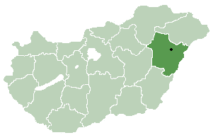
Mezőpeterd
Country  Hungary
County Hajdú-Bihar
Area
 – Total 18.23 km2 (7 sq mi)
Population (2001)
 – Total 578
 – Density 31.71/km2 (82.1/sq mi)
Time zone CET (UTC+1)
 – Summer (DST) CEST (UTC+2)
Postal code 4118
Area code(s) 54
Location of Hajdú-Bihar county in Hungary

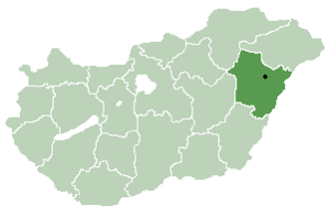
Mezőpeterd is a village in Hajdú-Bihar county, in the Northern Great Plain region of eastern Hungary.

Geography

It covers an area of 18.23 km2 (7 sq mi) and has a population of 578 people (2001).

Coordinates: 47°10′N 21°37′E / 47.167°N 21.617°E / 47.167; 21.617


Wikimedia Foundation. 2010.

Игры ⚽ Нужна курсовая?

Look at other dictionaries:

  • Mezőpeterd — Administration …   Wikipédia en Français

  • Bástya Panzió és Étterem — (Mezőpeterd,Венгрия) Категория отеля: Адрес: 4118 Mezőpeterd, Kossuth utca …   Каталог отелей

  • Debrecen — Debrecen …   Wikipedia

  • Hajdú-Bihar County — Infobox Hungarian county name =Hajdú Bihar region =Northern Great Plain seat = Debrecen area = 6211 population = 543,800 density = 87 cities = 82Hajdú Bihar is an administrative county (comitatus or megye) in eastern Hungary, on the border with… …   Wikipedia

  • Csökmő — Country  Hungary County Hajdú Bihar Area  – Total 68.97 km2 (26.6 sq …   Wikipedia

  • Derecske — Country  Hungary County Hajdú Bihar Area    Total 103.58 km2 (40 sq …   Wikipedia

  • Nagyhegyes — Country  Hungary County Hajdú Bihar Area  – Total 132.76 km2 (51.3 s …   Wikipedia

  • Nagykereki — Nagykereki …   Wikipedia

  • Magyarhomorog — Country  Hungary County Hajdú Bihar Area    Total 39.56 km2 (15.3  …   Wikipedia

  • Darvas — For the Romanian village of Dărvaş, see Bujoreni, Teleorman. Darvas Country  Hungary County Hajdú Bihar Area …   Wikipedia

Share the article and excerpts

Direct link
Do a right-click on the link above
and select “Copy Link”