- Brush Creek (Sonoma County, California)
Geobox|River
name = Brush Creek
native_name =
other_name = Rincon Creek
category =stream
etymology =
nickname =
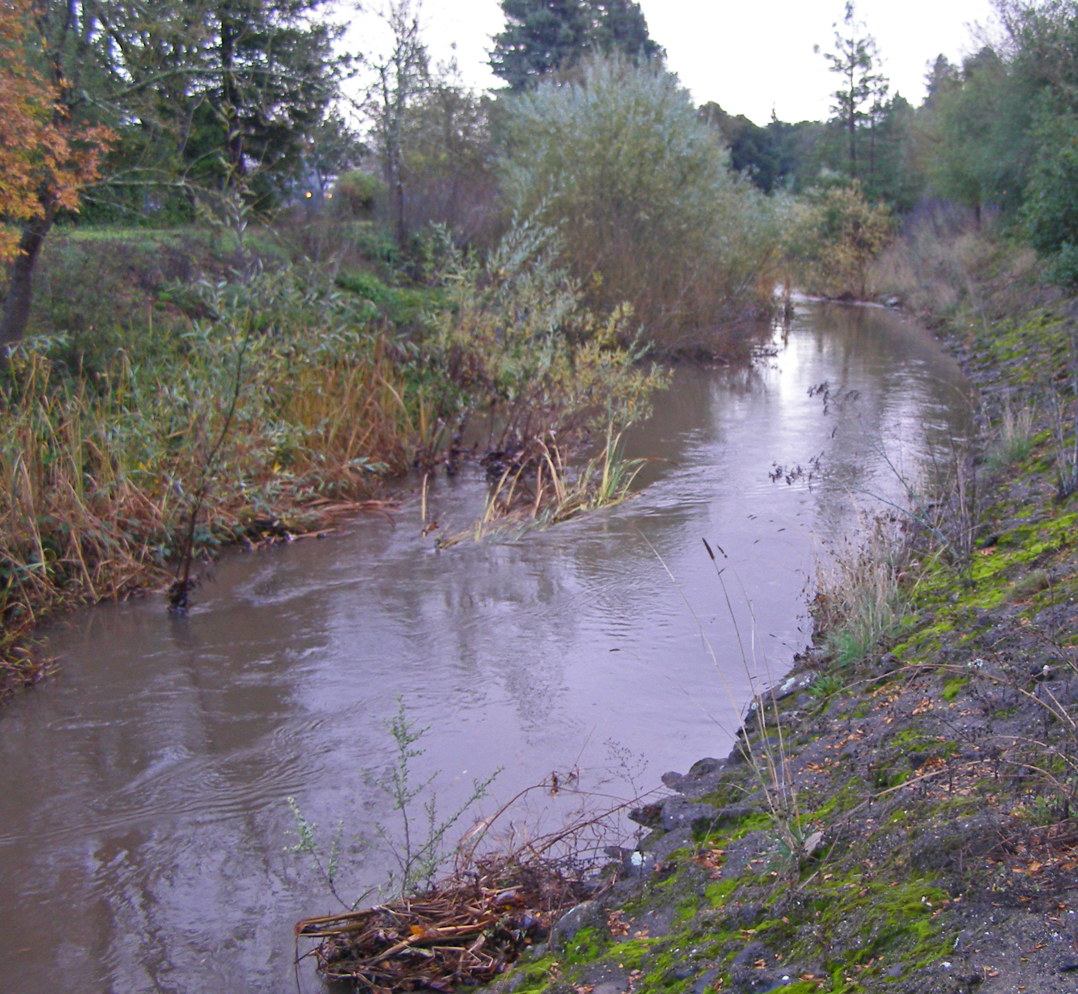
image_caption = Brush Creek looking south toward the Highway 12 bridge.
country =United States
state =California
region = Sonoma County
district =
municipality =
parent =
tributary_right =
tributary_left =
city =Santa Rosa, California
landmark =
river =
source =
source_location = north ofSanta Rosa, California
source_region = | source_country =
source_elevation_imperial = 577
source_elevation_note =
source_lat_d = 38 | source_lat_m = 30 | source_lat_s = 34 | source_lat_NS = N
source_long_d = 122 | source_long_m = 41 | source_long_s = 48 | source_long_EW = W
source_coordinates_note =
source1 =
source1_location = | source1_region = | source1_country =
source1_elevation_imperial =
source1_lat_d = | source1_lat_m = | source1_lat_s = | source1_lat_NS =
source1_long_d = | source1_long_m = | source1_long_s = | source1_long_EW =
source_confluence =
source_confluence_location = | source_confluence_region = | source_confluence_country =
source_confluence_elevation_imperial =
source_confluence_lat_d = | source_confluence_lat_m = | source_confluence_lat_s = | source_confluence_lat_NS =
source_confluence_long_d = | source_confluence_long_m = | source_confluence_long_s = | source_confluence_long_EW =
mouth =Santa Rosa Creek
mouth_location =Santa Rosa, California
mouth_region = | mouth_country =
mouth_elevation_imperial = 210
mouth_lat_d = 38 | mouth_lat_m = 27 | mouth_lat_s = 9 | mouth_lat_NS = N
mouth_long_d = 122 | mouth_long_m = 40 | mouth_long_s = 40 | mouth_long_EW = W
mouth_coordinates_note = Gnis|231600|Rincon Creek]
length_imperial =
length_note =
length_orientation =
width_imperial = | width_orientation =
depth_imperial =
volume_imperial =
warershed_imperial =
discharge_location =
discharge_location_note =
discharge_imperial =
discharge_round =
discharge_max_imperial =
discharge_min_imperial =
free = | free_type =
map_caption =
map_background =
map_locator =
map_locator_x =
map_locator_y =
website =
footnotes =Brush Creek is a tributary of
Santa Rosa Creek inSonoma County, California . ["Santa Rosa Quadrangle", Fifteen minute series,USGS Quadrangle Map, U.S. Government Printing Office, Washington DC (1958)] Brush Creek rises in the southern slopes of theMayacamas Mountains within Sonoma County. The lower reach of the creek is a suburban medium density residential area in the city of Santa Rosa, and that reach of Brush Creek has been restored during the 1990s under aU.S. Environmental Protection Agency grant to promotesteelhead migration and spawning. Further restoration and incorporation into city-wide park planning is currently underway as of 2006. The location of the confluence with Santa Rosa Creek is particularly noteworthy, since it was a locus of prehistoric life as avillage of thePomo people and a scenic geologic feature of massive flat boulderoutcrop s within the stream channel.Brush Creek is a watercourse of approximately three miles in length that drains the area known as Rincon Valley in north Santa Rosa and the outlying unincorporated areas. As recently as 1972 the lower reaches of Brush Creek were called Rincon Creek. On current maps, Rincon Creek is a
tributary that forms a confluence with Brush Creek approximately four kilometers upstream from the mouth of Brush Creek (near Montecito Boulevard). Thus today's nomenclature makes Rincon Creek essentially the west fork of upper Brush Creek.Lower reach and confluence with Santa Rosa Creek
The Flat Rocks feature at the confluence with Santa Rosa Creek was an important element of the prehistoric Pomo village at this site and is currently a picturesque protected area for trail
hiker s to enjoy. Immediately above the confluence is a modified channel that was designed to allow encroachment by residential development. The open channel has an obvious geometric form where banks have been steepened from the natural original contours; nevertheless, there is considerableriparian vegetation ofArroyo willow and Broad-leaf cattail ("Typha latifolia "). Chief native trees along the banks are Coast live oak ("Quercus agrifolia ") and Garry oak ("Quercus garryana ").Low flows at the end of summer amount to no more than a few cubic feet (50-100 liters) per second; however, after one of the first rains of autumn of approximately convert|1|in|cm|0|abbr=on, the flow increases to about convert|120|cuft|m3|0|abbr=on per second. Substantial energy dissipation is achieved by the willows and cattails that choke the creek in this reach. The sides are partially armored with
asphalt to achieve stabilization of the unnatural slope and to minimize scouring anderosion . In this reach of Brush Creek, Ducker Creek joins from the east and a west fork of Brush Creek forms a confluence somewhat higher from the west.Soils comprising the
streambed of upper and lower reaches are classified as theriverwash series in the U.S.Soil Conservation Service Classification System. These materials according to theU.S. Department of Agriculture , consist of very recent deposition ofgravel andsilt alluvium along streams. ["Soil Survey, Sonoma County, California",U.S. Department of Agriculture ,Soil Conservation Service , Government Printing Office, Washington DC, May 1972] Layering of soils and gravels brought in from higher elevations has resulted to form the streambed.Upper reach
The upper reach may be defined as that portion of the watershed above Montecito Boulevard, most of which is in the unincorporated area of Sonoma County. In these reaches the creek has little modification, save for residential development along Anderson Drive which encroaches into the
riparian area. Thus there are no flood control channel improvements, other than the Middle Fork Brush Creek reservoir constructed near Saddle Creek Drive. Above Badger Road there is a dam across Brush Creek, forming this smallreservoir . Headwaters of Brush Creek flow into the reservoir from two forks. There is virtually no public access to the creek or reservoir in the upper reach. There is less cattail vegetation and more mature Garry oaks andValley oak s in this reach. Above Baird the landscape turns into chiefly agriculturalgrazing land in the lowerfoothills of the Mayacmas western slopes.References
ee also
*
Coho salmon
*List of watercourses in the San Francisco Bay Area External links
* [http://ci.santa-rosa.ca.us/default.aspx?PageId=352#2 City of Santa Rosa Public Works Department Streams Restoration Project]
* [http://yosemite.epa.gov/water/restorat.nsf/0a37e6837198223485256a55005451f2/934e722bab80161185256c6b00601d3b!OpenDocument U.S. Environmental Protection Agency grant funded restoration project for Brush Creek]
Wikimedia Foundation. 2010.