- 1982 Atlantic hurricane season
Infobox hurricane season
Basin=Atl
Year=1982
Track=1982 Atlantic hurricane season map.pngJune 2 ,1982
Last storm dissipated=October 2 ,1982
Strongest storm name=Debby
Strongest storm winds=115
Strongest storm pressure=950
Average wind speed=1
Total depressions=9
Total storms=6
Total hurricanes=2
Total intense=1
Fatalities=141
Da
Inflated=1
five seasons=1980, 1981, 1982, 1983, 1984June 1 ,1982 , and lasted untilNovember 30 ,1982 . These dates conventionally delimit the period of each year when mosttropical cyclone s form in theAtlantic basin .Few storms formed in 1982, and those that did were generally weak and remained at sea. The deadliest storm of the season was Tropical Storm Beryl, which killed 115 people while crossing the
Cape Verde islands. Other notable storms include Hurricane Alberto, which caused torrential flooding in westernCuba ; Hurricane Debby, which reachedCategory 4 strength unusually far north; and asubtropical storm which formed and moved across Florida.__TOC__
easonal activity
The 1982 season was low in activity, with only six storms forming. The season started early with Hurricane Alberto forming on the first day of the season. Alberto threatened the Southwestern
Florida coast as a tropical storm, causing twenty-three fatalities inCuba . The next storm, Subtropical Storm One, formed in June and affected the same area as Alberto. The subtropical storm caused $10 million dollars in damage.Tropical Storm Beryl formed on
August 28 , after a quiet July in the openAtlantic Ocean . Beryl grazed TheCape Verde Islands , killing 115 people. Tropical Depression Three formed just behind Beryl, tracking east and north of the Caribbean sea in early September. Soon after the dissipation of Beryl, Tropical Storm Chris formed in theGulf of Mexico onSeptember 9 . Chris stayed as a weak storm, making landfall near Sabine Pass, Texas and dissipated over land onSeptember 13 . Hurricane Debby was the next storm and the strongest of the season. The formative stage of Debby produced rainfall inPuerto Rico and soon strengthened into a Category 4 Major Hurricane. Debby passed by Newfoundland onSeptember 18 and merged with a non-tropical low onSeptember 20 . In mid-September, Tropical Depression Six formed west of Africa, and tracked east-northeast, dissipating before reaching the Leeward Islands onSeptember 20 . Its remnant thunderstorm activity continued moving west-northwest, forming Tropical Depression Seven which moved near Bermuda onSeptember 25 before dissipating offshore Nova Scotia. The final storm of the season, Tropical Storm Ernesto, was the shortest lasting storm of the season and stayed out to sea, dissipating onOctober 3 .The season was very inactive because of strong vertical
wind shear due to stronger than normal westerly winds aloft. [Gilbert B. Clark. [http://www.aoml.noaa.gov/general/lib/lib1/nhclib/mwreviews/1982.pdf Atlantic Hurricane Season of 1982.] Retrieved on2008-05-23 .] The wind shear was contributed by a variety of factors including anEl Niño . Vertical wind shear was strong enough to disrupt convection in areas of disturbed weather so they could not develop further. TheEl Niño which affected this hurricane season extended into the1983 Atlantic hurricane season . [William S. Kessler. [http://faculty.washington.edu/kessler/ENSO/soi-1950-98.gifSouthern Oscillation Index.] Retrieved on2008-05-23 .] Higher than average values of Africanmineral dust during the most active portion of the hurricane season could have also suppressed tropical cyclone activity. [Amato T. Evan, Jason Dunion, Jonathan A. Foley, Andrew K. Heidinger, and Christopher S. Velden. [http://cimss.ssec.wisc.edu/clavr/amato/2006GL026408.pdf New Evidence For a Relationship Between Atlantic Tropical Cyclone Activity and African Dust Outbreaks.] Retrieved on2008-05-23 .]torms
Hurricane Alberto
Infobox Hurricane Small
Basin=Atl.jpg)
Track=Alberto 1982 track.pngJune 2
Dissipated=June 6
1-min winds=75
Pressure=985June 1 , a tropical depression formed off westernCuba from an organized cloud system. It moved slowly northeastward through theGulf of Mexico , and strengthened into Tropical Storm Alberto onJune 3 . Alberto traveled generally northeast on an erratic course, and briefly intensified to a Category 1 hurricane, one of the earliest hurricanes of June. Alberto then quickly weakened into a tropical storm, doubled back to the west, and dissipated near theFlorida Keys onJune 6 . Alberto is an example of a storm to enter the Gulf of Mexico and dissipating while never make landfall, which is an unusual event. [National Hurricane Center . [http://www.nhc.noaa.gov/tracks1851to2007_atl_reanal.txt Atlantic Hurricane Database.] Retrieved on2008-05-23 .]Though the storm never made landfall, 23 deaths were reported in Cuba from heavy flooding. Southern
Florida experienced moderate rainfall, with a peak of convert|16.47|in|mm occurring in Tavernier. [David Roth. [http://www.hpc.ncep.noaa.gov/tropical/rain/alberto1982.html Hurricane Alberto Rainfall Totals.] Retrieved on2006-10-21 .] [Miles B. Lawrence. [http://www.nhc.noaa.gov/archive/storm_wallets/atlantic/atl1982-prelim/alberto/ Hurricane Albero Report.] Retrieved on2006-10-21 .]ubtropical Storm One
Infobox Hurricane Small
Basin=Atl
Type=subtropical.jpg)
Track=1982 Atlantic subtropical storm 1 track.pngJune 18
Dissipated=June 20
1-min winds=60
Pressure=984subtropical storm of the season formed in the east-central Gulf of Mexico onJune 18 , and took an almost straight course to the northeast for its entire life. It crossed the Florida peninsula that night, causing the issuance of numerous severe thunderstorm and tornado warnings. The storm continued, crossing theOuter Banks ofNorth Carolina , and retained its strength untilJune 20 when it becameextratropical near Newfoundland.Subtropical Storm One caused three deaths in Florida, sank a
fishing trawler off the coast of North Carolina, and caused $10 million in damage (1982 USD, $20 million 2005 USD). [Joseph Pelissier. [http://www.nhc.noaa.gov/archive/storm_wallets/atlantic/atl1982-prelim/subtrop/ Subtropical Storm One Report] Retrieved on2006-10-21 .]Tropical Storm Beryl
Infobox Hurricane Small
Basin=Atl
Track=Beryl 1982 track.pngAugust 28
Dissipated=September 6
1-min winds=60
Pressure=989tropical wave moved off the coast ofAfrica onAugust 27 , and quickly organized into a tropical depression . By late onAugust 28 , it intensified into Tropical Storm Beryl, and passed just south of theCape Verde Islands . The storm steadily intensified, and attained peak winds of convert|70|mph|km/h onAugust 31 . An eye featured developed on satellite imagery, though it quickly disappeared as upper-levelwind shear increased.cite web|author=National Hurricane Center|year=1983|title=Tropical Storm Beryl (1982) Preliminary Report Page 1|publisher=National Hurricane Center|accessdate=2007-04-05|url=http://www.nhc.noaa.gov/archive/storm_wallets/atlantic/atl1982-prelim/beryl/prelim01.gif] OnSeptember 2 , Beryl weakened to tropical depression status, and onSeptember 6 it dissipated to the north of theLesser Antilles .cite web
author=National Hurricane Center
year=1983
title=Tropical Storm Beryl (1982) Prelimary Report - Section 2 - Storm History II
publisher=National Hurricane Center
accessdate=2007-04-05
url=http://www.nhc.noaa.gov/archive/storm_wallets/atlantic/atl1982-prelim/beryl/prelim02.gif]Early in its duration, Tropical Storm Beryl produced heavy rainfall and gusty winds on the Cape Verde island of Sal; the island was struck the hardest by the storm. The storm caused moderate damage across the archipelago, totaling $3 million (1982 USD).cite web|author=EM-DAT: the International Disaster Database|year=2007|title=Disaster List for Cape Verde|publisher=Centre for Research on the Epidemiology of Disasters|accessdate=2007-03-08|url=http://www.em-dat.net/index.htm] The passage of Beryl also resulted in 115 casualties in the country. In the period after the storm's passage, the United States provided humanitarian aid and economic assistance to the country, helping the archipelago to reverse the effects of Beryl.cite web|author=Geography I.Q.|year=2007|title=U.S.-CAPE VERDEAN RELATIONS|publisher=Geography I.Q.|accessdate=2007-04-05|url=http://www.geographyiq.com/countries/cv/Cape_Verde_us_relations_summary.htm]
Tropical Depression Three
Infobox Hurricane Small
Basin=Atl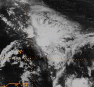
Formed=September 6
Dissipated=September 9
1-min winds=30This system formed east of the Lesser Antilles onSeptember 6 to the southeast of Tropical Storm Beryl. The depression moved northeast of the Leeward Islands during the afternoon ofSeptember 7 while experiencing southwest verticalwind shear , and moved into the southwest North Atlantic before dissipating east of the Bahamas onSeptember 9 .Tropical Storm Chris
Infobox Hurricane Small
Basin=Atl.jpg)
Track=Chris 1982 track.pngSeptember 9
Dissipated=September 12
1-min winds=55
Pressure=994low pressure area developed onSeptember 8 in theGulf of Mexico . It drifted westward, and the next day it organized into a subtropical depression. Under the influence of a trough of low pressure, the depression turned northward, and after steadily becoming better organized it transitioned into Tropical Storm Chris by late onSeptember 10 . The storm attained peak winds of convert|65|mph|km/h before moving ashore nearSabine Pass inTexas . Chris continued inland until it dissipated over centralArkansas onSeptember 13 . Prior to making landfall, as many as 6,500 people evacuated from southern Louisiana, while offshore many oil workers were evacuated inland.cite web
author=Gilbert B. Clark
year=1982-09-27
title=Tropical Storm Chris Prelimary Report
publisher=National Hurricane Center
accessdate=2007-03-28
url=http://www.nhc.noaa.gov/archive/storm_wallets/atlantic/atl1982-prelim/chris/prelim01.gif]Chris produced moderate rainfall along its path, peaking at convert|16|in|mm in
Delhi, Louisiana , with totals of over convert|10|in|mm inMississippi andTennessee .cite web
author=David Roth
year=2007
title=Tropical Cyclone Rainfall: Tropical Storm Chris
publisher=Hydrometeorogical Prediction Center
accessdate=2007-03-28
url=http://www.hpc.ncep.noaa.gov/tropical/rain/chris1982.html ] The rainfall caused locally severe flooding as far inland as Tennessee andKentucky , with flooding of some rivers reported.cite web
author=U.S. Geological Survey Kansas Water Science Center
year=2007
title=Summary of Significant Floods in the United States, Puerto Rico, and the Virgin Islands, 1970 Through 1989 - 1982
publisher=U.S. Geological Survey Kansas Water Science Center
accessdate=2007-03-28
url=http://ks.water.usgs.gov/Kansas/pubs/reports/wsp.2502.sum82.html#HDR1] The storm spawned 9 tornadoes, of which 4 were F2 or stronger on theFujita scale .cite web
author=Tom Grazulis of The Tornado Project and Bill McCaul of USRA Huntsville
year=2007
title=List of Known Tropical Cyclones Which Have Spawned Tornadoes
publisher=Tornado Project
accessdate=2007-03-28
url=http://www.tornadoproject.com/alltorns/allhurricanes.htm] Upon moving ashore, the hurricane produced a convert|5|ft|m to convert|6|ft|mstorm tide , resulting in severe damage to several boats in the Gulf of Mexico. Throughout its path, damage totaled $2 million (1982 USD).Hurricane Debby
Infobox Hurricane Small
Basin=Atl.jpg)
Track=Debby 1982 track.pngSeptember 13
Dissipated=September 20
1-min winds=115
Pressure=950tropical wave that degenerated shortly after leaving the coast ofAfrica . The wave travelled across the Atlantic, and organized into a tropical depression off the northern coast ofHaiti onSeptember 13 . The depression turned north and strengthened into a tropical storm and then a hurricane. Hurricane Debby moved north-northeast, brushingBermuda with tropical storm-force winds. It continued strengthening as it moved north, peaking at convert|135|mph|km/h. Tropical storm-force winds were also recorded atCape Race in Newfoundland when Debby passed onSeptember 18 . The storm accelerated and began weakening over the colder waters of the north Atlantic. Debby merged with a strong non-tropical system over theBritish Isles onSeptember 20 .The precursor disturbance to Debby dropped heavy rainfall across
Puerto Rico , peaking at convert|12.86|in|mm in the southwestern portion of the island. [David Roth. [http://www.hpc.ncep.noaa.gov/tropical/rain/debby1982.html Hurricane Debby Rainfall Totals.] Retrieved on2006-10-21 .] [National Hurricane Center . [http://www.nhc.noaa.gov/archive/storm_wallets/atlantic/atl1982-prelim/debby/ Hurricane Debby Report.] Retrieved on2006-10-21 .] Only minor damage was associated with Debby.Tropical Depression Six
Infobox Hurricane Small
Basin=Atl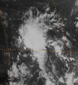
Formed=September 16
Dissipated=September 20
1-min winds=30This tropical depression formed convert|900|mi|km west of the Cape Verde Islands onSeptember 16 , [Associated Press . [http://www.thehurricanearchive.com/Viewer.aspx?] Retrieved on
2008-05-23 .] and moved west-northwest across the tropical Atlantic ocean. [Associated Press . [http://www.thehurricanearchive.com/Viewer.aspx?] Retrieved on
2008-05-23 .] The system moved within convert|750|mi|km east of the Leeward Islands before dissipating onSeptember 20 . [Associated Press . [http://www.thehurricanearchive.com/Viewer.aspx?] Retrieved on
2008-05-23 .]Tropical Depression Seven
Infobox Hurricane Small
Basin=Atl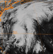
Formed=September 25
Dissipated=September 27
1-min winds=30The remnant area of disturbed weather from Tropical Depression Six continued moving west-northwest into the southwest north Atlantic. A tropical depression formed from this area convert|275|mi|km west of Bermuda onSeptember 25 . [Associated Press . [http://www.thehurricanearchive.com/Viewer.aspx?] Retrieved on
2008-05-23 .] The system recurved off the north and northeast, dissipating in north Atlantic shipping lanes southeast of Nova Scotia onSeptember 27 . [Associated Press . [http://www.thehurricanearchive.com/Viewer.aspx?] Retrieved on
2008-05-23 .] [Associated Press . [http://www.thehurricanearchive.com/Viewer.aspx?] Retrieved on
2008-05-23 .]Tropical Storm Ernesto
Infobox Hurricane Small
Basin=Atl
Track=Ernesto 1982 track.pngSeptember 30
Dissipated=October 2
1-min winds=60
Pressure=997Africa onSeptember 23 . The west side of the wave expanded and was declared as Tropical Depression Six onSeptember 30 . The depression intensified, making a sharp turn onOctober 1 . An Air Force plane found convert|40|mph|km/h winds with a pressure of 1003 mbar and the depression was given the name Ernesto. A second Air Force plane onOctober 2 found convert|71|mph|km/h winds with a pressure of 997 mbar. ByOctober 3 , Ernesto was not identifiable after merging with an extratropical low. Ernesto never approached land and caused no reported damage. [Miles B. Lawrence. [http://www.nhc.noaa.gov/archive/storm_wallets/atlantic/atl1982-prelim/ernesto Tropical Storm Ernesto Report.] Retrieved on2006-10-21 .]Accumulated Cyclone Energy (ACE) Rating
The table on the right shows the ACE for each storm in the season. The ACE is, broadly speaking, a measure of the power of the hurricane multiplied by the length of time it existed for, so hurricanes that lasted a long time have higher ACEs. ACE is only rated to systems with winds higher than 35 mph.
torm names
The following names were used for named storms that formed in the north Atlantic in 1982. No names were retired, so it was used again in the 1988 season. This is the first time these names were used since the post-1978 naming change, except for Florence and Helene which had been previously used in 1954, 1958, 1960, and 1964. Names that were not assigned are marked in tcname unused.
Retirement
The
World Meteorological Organization retired no names used in the 1982 season.ee also
*
List of Atlantic hurricanes
*List of Atlantic hurricane seasons
*1982 Pacific hurricane season
*1982 Pacific typhoon season
*1982 North Indian Ocean cyclone season
*Southern Hemisphere tropical cyclone seasons: 1981–82, 1982–83References
External links
* [http://www.aoml.noaa.gov/general/lib/lib1/nhclib/mwreviews/1982.pdf Monthly Weather Review]

Wikimedia Foundation. 2010.