- Loa River
Infobox_River
river_name = Loa River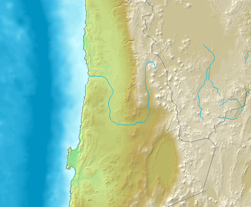
caption = Map
origin = near coord|21.1996|S|68.668|W|display=inline|region:CL-AN_type:river
mouth = coord|21.43|S|70.0576|W|display=inline,title|region:CL-AN_type:river intoPacific Ocean
basin_countries =Chile
length = 440 km Es icon [http://www.sinia.cl/1292/articles-31018_Loa.pdf Cuenca del río Loa] ]
elevation = 4,277 m
discharge = 2.43 m³/s
watershed = 33,570 km²The Loa River is a U-shaped river in
Chile 's northernAntofagasta Region . It is the country's longest river and the main watercourse in theAtacama Desert . Its total length is estimated at about 440 km.Course
The Loa's sources are located on Andean mountain slopes at the foot of
Miño Volcano . The upper Loa basin is flanked on the west by a ridge with elevations that reach above 4,500 m, whereas to the east lies a volcanic chain, which separates it from endorrheic basins as that ofSalar de Ascotán .The river flows south on an elevated plateau, for about 150 km, to the
oasis ofChiu Chiu (Chee-ooh Chee-ohh). The upper courses of the river are at a considerable elevation above sea level and receive a large volume of water from the Andes, mainly of two major tributaries:San Pedro de Inacaliri River and Salado River. The former joins the Loa near Conchireservoir and the latter about 3 km south of Chiu Chiu. The water of its upper course and tributaries is fresh. However the lower course, as in all the rivers of this region becomes brackish.From Chiu Chiu, the Loa flows west and north in a great curve to
Quillagua (key-yah-gwah). After flowing for 115 km in this portion of its course and having ran through the city of Calama, the Loa receives the waters ofSan Salvador River at the locality of "Chacance". Thence the river flows north for about 80 km to Quillagua.From Quillagua, its dry channel turns westward again and marks the border between the regions of Tarapacá and Antofagasta. Along its lower course, the Loa flows through a 500-m-deep canyon, which crosses the
Chilean Coastal Range . The river reaches thePacific Ocean in lat. 21° 26' S., a few miles south of the old port of Huanillos (Wan-e-yoes).The hydrologic regime of the river basin is rain-dominated. The increase of its water volume occurs mainly in January and February, as a consequence of the phenomenon known locally as
Bolivian Winter .History
Its banks have been inhabited from early times. Evidence of this is the notable number of
geoglyph s,petroglyph s andpictograph s that are found along its course and in its upper basin.Another indication of its rich past is the
Pukará de Lasana .Bridges
To the south of Conchi reservoir, the river is spanned by an old railroad bridge, which is no longer used by the
Ferrocarril de Antofagasta a Bolivia , however it still holds the notability of being, at 104 m, one of the highest bridges in Chile.Es icon [http://www.sernatur.cl/scripts/sitio/destino_atractivo2.php?destino=173&atractivo=1459 Conchi Bridge] ]References
*1911
*This article draws partially on the corresponding article in the Spanish-language Wikipedia, accessedJuly 10 ,2007 .
Wikimedia Foundation. 2010.