- Biobío River
Infobox_River
river_name = Biobío River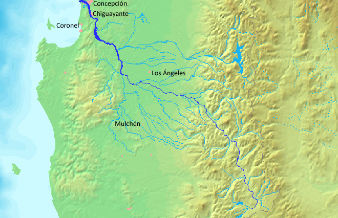
caption = Map
origin =Galletué Lake
mouth =Gulf of Arauco ,Pacific Ocean
basin_countries =Chile
length = 380 km [http://www.sinia.cl/1292/articles-31018_BioBio.pdf Cuenca del río Biobío] ]
elevation = 1,160 m
discharge = 899 m³/s
watershed = 24,264 km²The Biobío River (Also known as Bío Bío or Bio-BioFact|date=July 2007) is the second largest
river inChile . It originates from Icalma and Galletué lakes in theAndes and flows 380 km to theGulf of Arauco on thePacific Ocean .The major tributaries of the river are the Malleco and the Laja. The river is Chile's second-longest river (the longest being
Loa River ) and Biobío basin is Chile's third largest watershed, after Loa and Baker basins. The river is also the widest river in Chile, with an average width of 1 km. In theMetropolitan area of Concepción, the river is crossed by four bridges: Biobío Railroad Bridge (1889), Biobío Bridge (1942),Juan Pablo II Bridge (1973) and Llacolén Bridge (2000).Course
The Biobío river originates at the west shore of
Galletué Lake , within the national reserve that bears the same name. The river flows east for a few kilometers to the point where it receives the waters of the nearIcalma Lake , through a short stream. Then, it turns its course northwestward, meandering through Andean valleys and receiving the discharges from some minor tributaries, as are the "Lonquimay" and the "Rahue". The Lonquimay is fed by some glaciers of Sierra Nevada and passes close to the town of the same name. Just downstream from the confluence with the Rahue, the upper course of the river, locally known as "Alto Biobío", begins to run rapidly through narrowcanyon .After reaching the
Intermediate Depression , the river flows through a predominantly flat area, increasing its width between 60 to 120 meters and reducing its speed, which allows the navigation in some zones. In the middle course, theVergara River joins the Biobío in the vicinity of Nacimiento, draining a great part of southern river basin after receiving the waters of rivers such as the Malleco and the Renaico, which constitute a northwest-oriented and parallel network of drainage to the Biobío of a great part of the northern Andean portion of theAraucanía Region .To the east of
Chilean Coastal Range , near the cities ofSan Rosendo andLa Laja , Biobío River is joined by the Laja River, its major tributary in terms of volume of water. From here, the river follows its course increasing its width considerably, reaching 2 km wide at its mouth onPacific Ocean , nearSan Pedro de la Paz ,Gran Concepción .History
It was the traditional borderline during the
War of Arauco between southernMapuche self-ruled areas and northern Spanish-ruled Chile. The territory south of the river was not incorporated into the Chilean state until the 1880s after the campaigns of the "Pacification of the Araucanía ".In the early 1980s it was renowned as being one of world's best
whitewater rafting venues with a trip that lasted seven days through some of Chile's wilderness areas. Endesa, the Chilean state-run power company at that time, constructed thePangue dam , despite strong protests by environmentalists. With the loss of the whitewater rafting venue, there was also the displacement of indigenousPehuenche people, who had lived in the area for centuries.References
Sources
*This article draws partially on the corresponding article in the Spanish-language Wikipedia, accessed
July 10 ,2007 .See also
*
Bío-Bío Canal External links
* [http://www2.redenlaces.cl/webeducativos/hidrografia/zona3/cuenca6.htm Map of Biobío River]
* [http://encarta.msn.com/map_701565457/biobio.html Map of Biobío (river), Chile - World Atlas - MSN Encarta]
Wikimedia Foundation. 2010.