Rosebery, Tasmania

Rosebery, Tasmania

Infobox Australian Place | type = town
name = Rosebery
state = tas
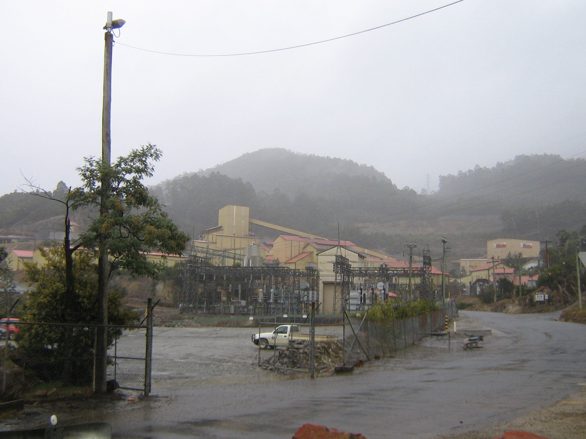


caption = Above-ground workings at the Rosebery mine
lga = West Coast Council
postcode = 7470
est =
pop = 1,032
pop_footnotes=
elevation= 165
elevation_footnotes= [ [http://www.bom.gov.au/climate/averages/tables/cw_097073.shtml Bureau of Meteorology] . Retrieved on 2007-11-14.]
maxtemp = 16.4
mintemp = 7.0
rainfall = 1952
stategov = Lyons
fedgov = Lyons
dist1 = 315
dir1 = NW
location1= Hobart
dist2 = 109
dir2 = S
location2= Burnie
dist3 = 55
dir3 = N
location3= Queenstown
dist4 = 25
dir4 = N
location4= Zeehan

Rosebery (coord|41|46|S|145|32|E|region:AU-TAS_type:city) is a town on the west coast of Tasmania, Australia. It is situated at the northern end of the West Coast Range, in the shadow of Mount Black and adjacent to the Pieman River now Lake Pieman.

It lies on the Murchison Highway, 25 kilometres north east of Zeehan and is part of the Municipality of West Coast Council. At the 2006 census, Rosebury had a population of 1,032.Census 2006 AUS|id=UCL614200 |name=Rosebery (Urban Centre/Locality)|accessdate=2007-11-14|quick=on]

The population of Rosebery declined by 22% in the years between 1996-2001. [ [http://www.rpdc.tas.gov.au/soer/indicator/55/index.php] ]

Its newer western area on the shore of Lake Pieman is known as Primrose.

Its postcode is 7470.

Mining and railways

Like most of the west coast, Rosebery is a mining town. In the 1890s, gold, lead, zinc and copper were all discovered in the area. This lasted until the mine's closure in 1913. In 1927 the Mount Lyell Mining and Railway Company revived the mines, and today the mines are still running (owned and operated by Oz Minerals).Prior to the construction of the Murchison Highway in the 1960s, the town connected with Burnie and North West Tasmania via the Emu Bay Railway.

Notable residents

* Richard Flanagan - author, historian and film director

ee also

*West Coast Tasmania Mines
*West Coast Tasmania Railways

References

Further reading

*
*
*: 2003 edition - Queenstown: Municipality of Queenstown. :1949 edition - Hobart: Davies Brothers. OCLC|48825404; ASIN [http://www.amazon.com/dp/B000FMPZ80 B000FMPZ80] :1924 edition - Queenstown: Mount Lyell Tourist Association. OCLC|35070001; ASIN [http://www.amazon.com/dp/B0008BM4XC B0008BM4XC]

External links

* [http://www.mrt.tas.gov.au/portal/page?_pageid=33,36514&_dad=portal&_schema=PORTAL Mineral Resources Tasmania - Zinifex Rosebery mine]
* [http://www.smh.com.au/news/Tasmania/Rosebery/2005/02/17/1108500205927.html Tourist information dated 2004]


Wikimedia Foundation. 2010.

Игры ⚽ Поможем решить контрольную работу

Look at other dictionaries:

  • Lake Rosebery (Tasmania) — Infobox lake lake name = Lake Rosebery image lake = Lake Rosebery.jpg caption lake = image bathymetry = caption bathymetry = location = West Coast, Tasmania coords = coord|41|44|S|145|35|E|type:waterbody region:AU|display=inline,title type =… …   Wikipedia

  • Rosebery — or Roseberry can mean:People*Earl of Rosebery several people including: **Archibald Primrose, 5th Earl of Rosebery, Prime Minister of the United Kingdom and **Hannah Primrose, Countess of Rosebery his wifePlaces;In Australia: *Rosebery, New South …   Wikipedia

  • Tasmania — Tasmanian, adj., n. /taz may nee euh, mayn yeuh/, n. an island S of Australia: a state of the commonwealth of Australia. 418,957; 26,382 sq. mi. (68,330 sq. km). Cap.: Hobart. Formerly, Van Diemen s Land. * * * formerly Van Diemen s Land Island… …   Universalium

  • Tasmania — Australia state or territory Name = Tasmania Fullname = State of Tasmania Motto = Ubertas et Fidelitas (Fertility and Faithfulness) Nickname = Island of Inspiration; The Apple Isle; Holiday Isle Emblems = Flora Tasmanian Blue Gum; Mineral… …   Wikipedia

  • Tasmania — Tasmanie Tasmania (Tasmanie) …   Wikipédia en Français

  • Rosebery — /rohz beuh ree/, n. Archibald Philip Primrose /prim rohz /, 5th Earl of, 1847 1929, British statesman and author: prime minister 1894 95. * * * ▪ Tasmania, Australia       town, western Tasmania, Australia, on the Pieman River. Named after… …   Universalium

  • Rosebery — I. /ˈroʊzbəri/ (say rohzbuhree), / bri/ (say bree) noun Archibald Philip Primrose, Earl of, 1847–1929, British politician and author; prime minister 1894–95. II. /ˈroʊzbəri/ (say rohzbuhree) noun a town in north western Tasmania, noted for mining …  

  • Williamsford, Tasmania — is the location of a former mining community, south of Rosebery, Tasmania and on the western lower reaches of Mount Read. It was formerly reached by the North East Dundas Tramway a line which operated between 1896 and 1929.[1][2] It was also the… …   Wikipedia

  • Geology of Tasmania — Tasmania has a varied geological history, with the world s biggest exposure of diabase, or dolerite. Rocks from the Neoproterozoic, Paleozoic and Mesozoic time periods appear. It is one of the few southern hemisphere areas glaciated during the… …   Wikipedia

  • Tullah, Tasmania — Tullah is a town in the northern part of the West Coast Range, on the west coast of Tasmania, about 111 km south of Burnie. The town has a population of roughly 270 people. The town is roughly divided into two suburbs , an older northern and a… …   Wikipedia

Share the article and excerpts

Direct link
Do a right-click on the link above
and select “Copy Link”