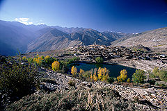
- Nako Lake
-
Nako Lake 
Location Kinnaur district Coordinates 31°52′47″N 78°37′39″E / 31.8796394°N 78.6276323°ECoordinates: 31°52′47″N 78°37′39″E / 31.8796394°N 78.6276323°E Lake type High altitude lake Basin countries India Surface elevation 3,662 m (12,010 ft) References Himachal Pradesh Tourism Dep. Nako Lake is a high altitude lake in the Pooh sub-division of district Kinnaur. It forms part of the boundary of Nako village and seems that the village is half buried in the lake's border. It is about 3,662 metres (12,014 ft) above sea level. The lake is surrounded by willow and poplar trees. Near the lake there are four Buddhist temples. Near this place there is a footlike impression ascribed to the saint Padmasambhava.And some miles away there is a village called TASHIGANG around this village there are several cave where it is believe that Guru Padmasambhava meditated and gave discourse to followers. There is a waterfall nearby which has snow water falling like a river of milk. Legend says that it is a heavenly realm of fairies.In one of the cave you can still able to see the live footprints of these fairies or other demigods. It is a sacred place for the people of these valley.Followers come from as far a place as Ladhak and spiti valley.[1]
References
External links
List of lakes in Himachal Pradesh Low altitude lakes Mid altitude lakes High altitude lakes Prashar Lake · Nako Lake · Chandra Tal · Suraj Tal · Dhankar Lake · Dashair · Brighu Lake · Seruvalsar Lake · Manimahesh Lake · Ghadhasaru Lake · Mahakali Lake · Lama Dal · Chander Naun · Kareri LakeReservoirs Categories:- Lakes of Himachal Pradesh
- Kinnaur
- Himachal Pradesh geography stubs
Wikimedia Foundation. 2010.
