- Ötztal
-
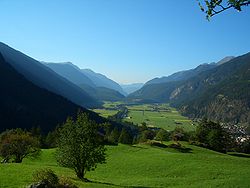 The Ötztal near Längenfeld
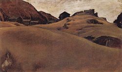 Alm landscape in the Ötztal, painting by Albin Egger-Lienz (1911).
The Ötztal is a 65-kilometer long alpine valley in the Austrian state of Tyrol. The Ötztaler Ache river flows through the valley in a northern direction. The Ötztal separates the Stubai Alps in the east from the Ötztal Alps in the west. The northern end of the valley is at the confluence of the Ötztaler Ache and Inn rivers, 8 kilometers east of Imst and 50 kilometers west of Innsbruck. Here is the only railway station of the valley, Ötztal railway station, which connects the Ötztal with the Arlberg railway (Innsbruck-Bludenz) and also a motorway interchange to the A12 (E60). The southern end of the valley, also called the Gurglertal (valley of the Gurgler) terminates at the border with Italy, formed by the main chain of the Alps, with many glaciers and high peaks, including the Weißkugel and the Similaun. The village of Obergurgl at the southern end of the Ötztal is the highest parish in Austria.
In 1991, Ötzi the Iceman, a well-preserved natural mummy from about 3300 BC, was found in the nearby Schnalstal glacier near the Finielspitze and the Similaun. The Ötzi monument is located about an hour's walk from the Similaun Hut.
The Ötztal comprises five municipalities (from north to south): Sautens, Oetz, Umhausen, Längenfeld and Sölden. The main industry in the valley is tourism: the mountains around the valley are popular with mountaineers and skiers. There are ski resorts in the upper part of the valley at Sölden, Hochsölden, and Hochgurgl. The Timmelsjoch mountain pass connects the Ötztal with the Passeier Valley and Merano in the province of South Tyrol, Italy.
The Ötztal Glacier Road is the highest paved road in the Alps. It is the access road from Sölden to the Rettenbach glacier and Tiefenbachferner glaciers, highest point at southern end of the tunnel 46°55′29″N 10°56′40″E / 46.92472°N 10.94444°E
See also
- List of highest paved roads in Europe
- List of mountain passes
Coordinates: 47°08′13″N 10°55′38″E / 47.13694°N 10.92722°E
Categories:- Tyrol geography stubs
- Valleys of Tyrol


Wikimedia Foundation. 2010.