- Dronne
-
For the French officer and politician, see Raymond Dronne.
Dronne 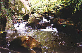
The Dronne at the rapids near Champs-RomainOrigin Massif Central Mouth Isle
45°2′15″N 0°8′54″W / 45.0375°N 0.14833°WCoordinates: 45°2′15″N 0°8′54″W / 45.0375°N 0.14833°WBasin countries France Length 201 km Source elevation 510 m Avg. discharge 25.1 m3/s The Dronne is a 201 km long river in southwestern France, right tributary of the Isle River. Its source is in the north-western Massif Central, east of the town of Châlus (south-west of Limoges) at an elevation of 510 m. It flows south-west through the following départements and towns:
- Haute-Vienne
- Dordogne: Saint-Pardoux-la-Rivière, Brantôme, Ribérac
- Charente: Aubeterre-sur-Dronne
- Charente-Maritime
- Gironde: Coutras
The Dronne flows into the Isle in Coutras.
Among its tributaries are the Lizonne and the Côle.
References
Categories:- Aquitaine geography stubs
- Rivers of France
- Dordogne basin
- Dordogne
- Gironde
- Haute-Vienne

Wikimedia Foundation. 2010.