- Komjatice
Geobox | Settlement
name = Komjatice
other_name =
category = Village
image_caption =
symbol =
etymology =
official_name =
motto =
nickname =
country = Slovakia
country_
state =
region = Nitra
district = Nové Zámky
commune =
municipality =
part =
river =
location =
elevation = 128
lat_d = 48
lat_m = 09
lat_NS = N
long_d = 18
long_m = 11
long_s = 60
long_EW = E
coordinates_type = region:SK_type:city
highest =
highest_elevation =
highest_lat_d =
highest_long_d =
lowest =
lowest_elevation =
lowest_lat_d =
lowest_long_d =
area = 30.7
area_round = 1
population = 4263
population_date = 2005-12-31
population_density = auto
established =
mayor =
timezone =
timezone_DST =
postal_code = 941 06
area_code = +421-35
code = NZ
code_type = Car plate
free =

map_background = Slovakia - background map.png
map_locator = Slovakia
map1 = Nitra Region - outline map.svg
map1_size = 192
map1_background = Nitra Region - background map.png
map1_locator = Nitra Region
commons =
statistics = [http://www.statistics.sk/mosmis/eng/prvav2.jsp?txtUroven420404&lstObec503282&Okruhzaklad MOŠ/MIS]
website = [http://www.komjatice.sk www.komjatice.sk]
footnotes =Komjatice ( _hu. Komját) is a
municipality and village in theNové Zámky District of the south-west ofSlovakia , in theNitra Region .History
Village was named after count Komjati.
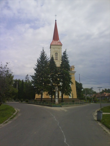
Places of interest
*Church of St. Elizabeth located in center of village
*Church of St. Peter and Paul located at western end of village
*Lake Štrkáreň located east of village along road to Černík.
*Park located in center of village contains some interesting nonnative trees.
*The Priest's Hole ("Kňazova jama")External links
*http://www.komjatice.sk


Wikimedia Foundation. 2010.