- Monte Córdova
-
Monte Córdova Civil Parish (Freguesia)  Coat of arms
Official name: Freguesia de Monte Córdova Country  Portugal
Region Norte Subregion Ave District Porto Municipality Santo Tirso Localities Cabanas, Hortel, Monte Córdova, Santa Luzia Center Monte Córdova - elevation 383 m (1,257 ft) - coordinates 41°19′13.84″N 8°25′52.94″W / 41.3205111°N 8.4313722°W Length 6.61 km (4 mi), West-East Width 4.23 km (3 mi), North-South Area 16.80 km2 (6 sq mi) Population 3,669 (2001) Density 218.39 / km2 (566 / sq mi) LAU Freguesia/Junta Freguesia - location Largo Monsenhor Moreira Neto, Quinchães, Monte Córdova, Santo Tirso President Junta Manuel da Silva Ferreira Leal (PPD-PSD) President Assembleia Manuel de Sousa Leal Ferreira (PPD-PSD) Timezone WET (UTC0) - summer (DST) WEST (UTC+1) ISO 3166-2 code PT- Postal Zone 4825-284 Monte Córdova Area Code & Prefix (+351) 252 XXX XXX Demonym Cordovense Patron Saint São Salvador Parish Address Largo Monsenhor Moreira Neto, Quinchães
4825-284 Monte CórdovaWikimedia Commons: Monte Córdova (Santo Tirso) Statistics: Instituto Nacional de Estatística[1] Website: http://www.jf-montecordova.pt Geographic detail from CAOP (2010)[2] produced by Instituto Geográfico Português (IGP) Monte Córdova is a civil parish in Portuguese municipality of Santo Tirso, located 4 kilometres east of the municipal seat. In 2001, its population was 3669 inhabitants, in an area of 16.80 km2 (6.49 sq mi): it is the largest parish by the area in the municipality.
Contents
History
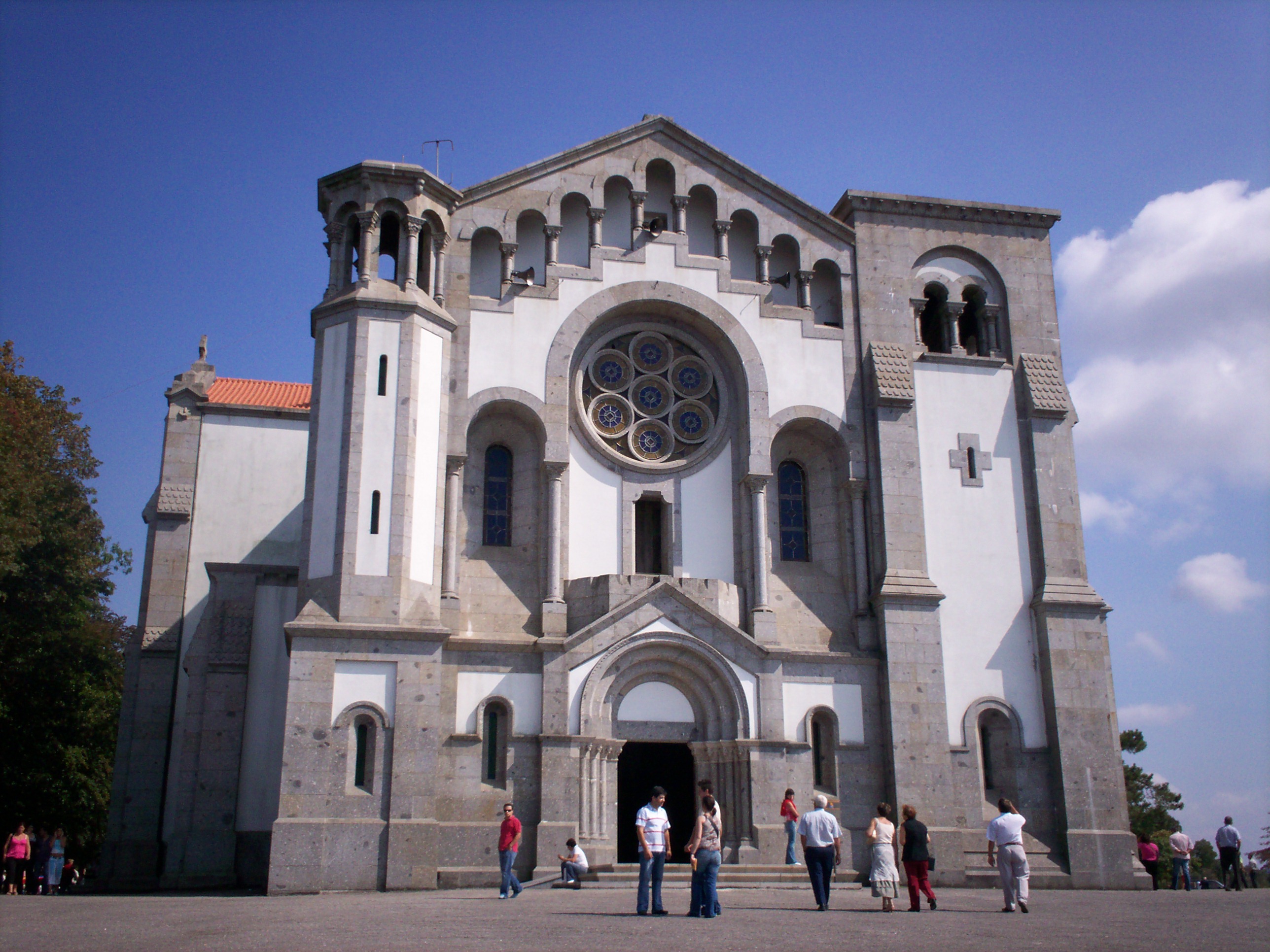
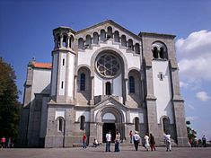 The Church of Nossa Senhora da Assunção overlooking the parishes of Santo Tirso and Monte Córdova
São Salvador de Monte Córdova is an ancient parish that was first mentioned in recorded documents in 959.[3]
Roman forces occupied this region, in order to pacify its populous, as part of its occupation from the Pyranees to Atlantic, Canterbury to the Mediterranean.[3] They forced a restructuring of society, promoting the occupation of the open plains rather then the hilltops, which were typical at the time. The difficulty encountered by the Romans in this area, resulted in the Greek historian Strabo identifying the Lusitanian region and its peoples are the most powerful groups in the Iberian peninsula.[3]
On Monte Padrão existed the ruins of a castro. The castro of Monte Padrão, until the end of the 16th century, existed as the parochial church, being under the primitive monastery of Celanova, in Galicia.[3]
Geography
The civil parish of Monte Córdova is situated 30 kilometres from Porto, and accessible through the EN105 motorway to many of the local communities, including Braga, Famalição Municipality|Famalicão and Guimarães.[3]
For many centuries, the geomorphology of the terrain was responsible for the relative isolation of its populations.[3] The parish is located at about 410-420 metres above sea level, in an area called the Agrela da Assunção escarpment.[3] Alto de Cabanas is one of the best natural lookouts in the region, and the area of Valinhas, with its monumental oak forests and curious chapel, near the Fervença waterfalls (or the Leça River), are almost obligatory natural sites of the landscape.[3]
Economy
For a long time Monte Córdova was considered the breadbasket of Santo Tirso (Portuguese: Celeiro de Santo Tirso).[3] But, primary activities have diminished considerably over time: in fact, the totality of the lands cultivated today only provide subsistence resources for the local community, or to compliment family income. The secondary economic activities are dominated by industrial activities such as sawmilling, carpentry and associated services.[3]
Architecture
The parish of Monte Córdova is proud of the many cultural monuments and buildings that are spread throughout its territory, but the following have been classified in the National Registry of Patrimony by IGESPAR:
Civic
- Castro of Monte Padrão (Portuguese: Castro de Monte Padrão)
- Monte Córdova Primary School (Portuguese: Escola Primária de Monte Cordova)
- Pereiras' Sierra Hydraulic Building (Portuguese: Edifício da Serra Hidráulica de Pereiras)
Religious
- Chapel of São Gonçalo (Portuguese: Capela de São Gonçalo)
- Church of Nossa Senhora da Assunção (Portuguese: Igreja da Nossa Senhora da Assunção) - authored by the Italian architect Korrrodi, the basilica-like church houses the image of Nossa Senhora da Assunção (Our Lady of the Assumption), considered one of the best conserved sculptures from the end of the 19th century sculpturer João da Fonseca Lapa.[3]
Culture
Annually, there are pilgrimages in honour of São Salvador, in the area of Santa Luzia envolving its 12th century chapel.[3]
References
- Notes
- ^ INE, ed. (2010) (in Portuguese), Censos 2011 - Resultadas Preliminares [2011 Census - Preliminary Results], Lisbon, Portugal: Instituto Nacional de Estatística, http://www.ine.pt/xportal/xmain?xpid=INE&xpgid=ine_publicacoes&PUBLICACOESpub_boui=122114780&PUBLICACOESmodo=2, retrieved 1 July 2011
- ^ IGP, ed. (2010) (in Portuguese), Carta Administrativa Oficial de Portugal, Lisbon, Portugal: Instituto Geográfico Português, http://www.igeo.pt/produtos/cadastro/caop/download/Areas_Freg_Mun_Dist_CAOP2010.zip, retrieved 1 July 2011
- ^ a b c d e f g h i j k l Junta Freguesia, ed. (2010) (in Portuguese), Monte Córdova, Monte Córdova (Santo Tirso), Portugal: Junta Freguesia de Monte Córdova, http://www.jf-montecordova.pt/, retrieved 28 August 2010
Categories:- Parishes of Portugal
- Porto geography stubs
Wikimedia Foundation. 2010.