Cape Meares Light

Cape Meares Light

Infobox Lighthouse


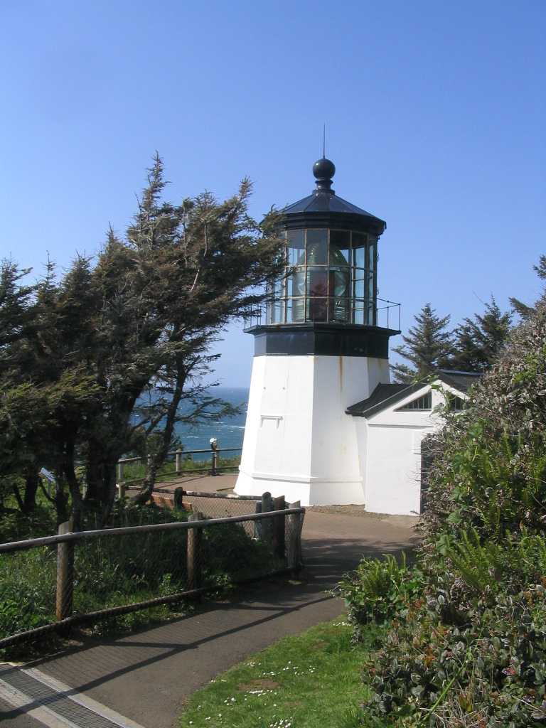
caption = Cape Meares Light
location = Cape Meares, Oregon
coordinates = coord|45|29|11.6|N|123|58|42.2|W|region:US_type:landmark
yearlit = 1890
automated =
yeardeactivated = 1963
foundation = Concrete
construction = Brick sheathed in sheet iron
shape = Octagonal
height = 38 ft
lens = First order Fresnel lens
range =
characteristic =

The Cape Meares Light is an inactive lighthouse on the coast of Oregon. It is located on Cape Meares just south of Tillamook Bay.

The lighthouse was first lit in 1890 and was deactivated in 1963. When it was built, the lighthouse complex included two keeper's houses, which were demolished in 1968, two oil houses, and two cisterns. Later additions included an 1895 workroom attached to the tower and a 1934 garage.cite web | date = March 6 2002 | url = http://www.cr.nps.gov/maritime/light/capemear.htm | title = Cape Meares Light | work = Inventory of Historic Light Stations | publisher = National Park Service | accessmonthday = November 1 | accessyear = 2006]

The lighthouse was replaced by a newer tower in 1963.

It was listed in the National Register of Historic Places in 1993 as reference number #73002341, and is open to the public.

See also

*List of lighthouses on the Oregon Coast

References

External links

* [http://www.oregonstateparks.org/park_181.php Cape Meares web site]


Wikimedia Foundation. 2010.

Игры ⚽ Поможем сделать НИР

Look at other dictionaries:

  • Cape Meares — is a small headland on the Pacific coast of northwest Oregon in the United States. The cape forms a high steep bluff on the south end of Tillamook Bay, approximately 5 mi (8 km) northwest of the town of Tillamook. Much of the cape is part of Cape …   Wikipedia

  • Cape Meares National Wildlife Refuge — Infobox protected area | name = Cape Meares National Wildlife Refuge iucn category = IV caption = Cape Meares as seen from nearby beach locator x = locator y = location = Oregon nearest city =Cape Meares lat degrees = 43 lat minutes = 6 lat… …   Wikipedia

  • Cleft of the Rock Light — Location Cape Perpetua, Oregon, U.S. Coordinates 44°17′26″N 124°06′39″W /  …   Wikipedia

  • Coquille River Light — Location Bandon, Oregon Coordinates …   Wikipedia

  • Desdemona Sands Light — Location Columbia Bar, Oregon, U.S. Coordinates 46°13′31″N 123°57′13″W /  …   Wikipedia

  • Coast Guard Station Cape Disappointment — United States Coast Guard Station Cape Disappointment, situated near Cape Disappointment, Washington at the mouth of the Columbia River, is the largest United States Coast Guard search and rescue station on the Northwest Coast, with 50… …   Wikipedia

  • Oregon Coast National Wildlife Refuge Complex — The Oregon Coast National Wildlife Refuge Complex consists of six National Wildlife Refuges along the Oregon Coast. It provides wilderness protection to thousands of small islands, rocks, reefs, headlands, marshes, and bays totaling 371 acres… …   Wikipedia

  • Oregon Coast — Southward view from Ecola State Park, Northern Oregon Coast The Oregon Coast is a region of the U.S. state of Oregon. It runs generally north south along the Pacific Ocean, forming the western border of the state; the region is bounded to the… …   Wikipedia

  • Lighthouses in the United States — This United States has hundreds of lights as well as light towers, range lights, and pier head lights. Michigan has the most lights of any state with over 130. See also: Lightvessels in the United States, lightvessel, List of lighthouses and… …   Wikipedia

  • List of lighthouses on the Oregon Coast — This is a complete list of existing public and private lighthouses on the Oregon Coast, in order from north to south. Not all of them are currently used for navigation. Tillamook Rock Light Seaside/Cannon Beach (deactivated) Cape Meares Light… …   Wikipedia

Share the article and excerpts

Direct link
Do a right-click on the link above
and select “Copy Link”