- Madrona Marsh
-
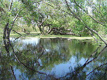
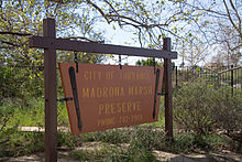
The Madrona Marsh Preserve, located in Torrance, California, is the last vernal marsh remaining in the South Bay area of Los Angeles and one of few wetlands located within an urban landscape.
Formed eons ago when the mountains of the Palos Verdes Peninsula rose to the south, Madrona Marsh is a shallow depression fed by wet season (spring) storms as the name "vernal" indicates. After the rainy season, evaporation, percolation and transpiration reduce the water depth by about one-quarter of an inch (6 mm) per day. By the end of August, the wetland is dry and remains so until the following rainy season. Situated on land that was set aside for oil production in 1924, Madrona Marsh was never developed—unlike the surrounding city—and remains a valuable natural habitat for birds, reptiles, insects and even small mammals.
Ongoing efforts are restoring native plants including wildflowers and butterfly species. The area has long been popular with bird watchers and The Audubon Society has used Madrona Marsh for their annual bird census since 1967. El Camino College uses it as an outdoor biology and botany lab. Public access to the Madrona Marsh trails is offered Tuesday through Sunday from 10 a.m. to 5 p.m. and guided tours can be arranged by calling the Nature Center (310) 782-3989.
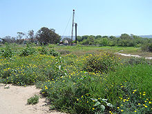
Oil infrastructure is also evident on the site.
The City of Torrance operates the Madrona Marsh Nature Center in cooperation with the Friends of the Madrona Marsh. Activities include bird and nature walks, natural history classes and workshops, habitat restoration, science and astronomy programs, art exhibits, and children's nature programs. The center opened in 2001 and features exhibits about the plants, birds and animals of the marsh.
The marsh and nature center are closed to the public on Mondays.
External links
- Madrona Marsh Nature Center, City of Torrance Parks and Recreation, including tour and activity schedules
- Friends of Madrona Marsh website with additional history and activity information.
Coordinates: 33°49′37″N 118°20′33″W / 33.82694°N 118.3425°W
Categories:- History of Los Angeles, California
- Marshes of California
- Nature centers in California
- Torrance, California
- Wetlands of California
- Protected areas of Los Angeles County, California
Wikimedia Foundation. 2010.


