- Alfonso Bonilla Aragón International Airport
Infobox Airport
name = Alfonso Bonilla Aragón International Airport
nativename = Aeropuerto Internacional Alfonso Bonilla Aragón
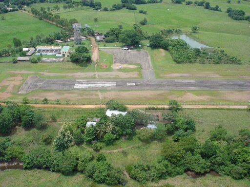
image-width = 250
IATA = CLO
ICAO = SKCL
type = Public
owner =
operator = Aerocali (Cali Aeronautical company)
city-served =Santiago de Cali
location =Palmira
elevation-f = 3162
elevation-m = 964
coordinates = Coord|03|32|35|N|76|22|53|W|type:airport
website = [http://www.aerocali.com.co/ www.aerocali.com.co]
r1-number = 01/19
r1-length-f = 9,500
r1-length-m = 3,000
r1-surface = Asphalt
footnotes =Alfonso Bonilla Aragón International Airport Airport codes|CLO|SKCL also known as Palmaseca International Airport is an
airport servingPalmira ,Colombia , and its suburbs. It is Colombia's second largest airport in terms of passengers, transporting 2,171,551 in 2006.Alfonso Bonilla Aragón is located in a long, narrow
valley that runs from north to south, and is surrounded bymountain s up to 14,000 feet (4,000 m) high. This makes landing at the airport notoriously difficult, and has led to many accidents. The airport has onerunway , 9,500 feet (3000 m) inlength . This runway is paved, and at anelevation of 3,162 feet (962 m). The runway can serve aircraft up to the size of aBoeing 747 .The airport is notable in that it is one of the few secondary airports in
Latin America open 24 hours a day.History
*El Guabito: The first airport in cali was located within a military base called "El Guabito." The airport was inaugurated on September 21th 1933, with mixed commercial and military operations.
*Calipuerto: As air traffic increased, it became necessary to separate military and commercial aviation operations. As a result, a new airport was built in the middle of the Cauca Valle to the southeast of Cali, inaugurated on April 17, 1943.
*Palmaseca International Airport: When Cali was awarded the hosting of the 1972 Panamerican games local authorities decided to build a new airport capable of handling the air traffic generated by the event. The site chosen was near the village of Palmaseca, roughly in the middle of the Cauca valley between Palmira and Cali. The airport was inaugurated on July 24th 1971, and save a few minor modifications has not been changed at all, testament to the accuracy of long-term air traffic and passenger volume planning.Important events
On
December 20 ,1995 ,American Airlines Flight 965 on route fromMiami to Aragon Airport crashed into a mountain near Cali due to pilot error; a guidance system error made by reprogramming the onboard computer led the aircraft to a mountain unseen by pilots in the dark.Airlines and destinations
*
American Airlines (Miami)
*Avianca (Bogotá, Madrid, Medellín, Miami, New York-JFK, Pasto, Tumaco)
** SAM (Barranquilla, Bogotá, Cartagena, Medellín, San Andrés Island [seasonal] )
*Copa Holdings
**AeroRepública (Bogotá, Cartagena, Panama City, San Andrés Island)
**Copa Airlines (Panama City)
*TAME (Tulcan)
*AIRES (Pereira, Medellín-Olaya Herrera)
*SATENA (Guapi, Ipiales, Medellín-Olaya Herrera, Quibdó, Tumaco)
* TAC (Timbiqui, El Charco) [charter]References
* [http://www.aerocali.com.co/index.php Official Airport Site] es icon
*
* [http://azworldairports.com/airports/p1370clo.htm A-Z World Airports: Cali - Alfonso Bonilla Aragón Airport (CLO/SKCL)]
Wikimedia Foundation. 2010.