- Machias Seal Island
Infobox Islands
name = Machias Seal Island
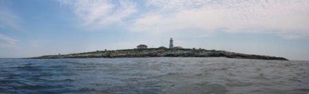
image caption = "Machias Seal Island"
image size = 250px
locator
native name =
native name link =
nickname =
location =Gulf of Maine
coordinates = coord|44|30|10|N|67|06|10|W|type:isle
archipelago = Grand Manan Archipelago (disputed)
total islands = 1
major islands =
area = convert|8|ha|acre|1|lk=on|abbr=on
highest mount =
elevation =
country =
country admin divisions title =
country admin divisions =
country admin divisions title 1 =
country admin divisions 1 =
country admin divisions title 2 =
country admin divisions 2 =
country capital city =
country largest city =
country largest city population =
country leader title =
country leader name =
country 1 =
country 1 admin divisions title =
country 1 admin divisions =
country 1 capital city =
country 1 largest city =
country 1 largest city population =
country 1 leader title =
country 1 leader name =
country 2 =
country 2 admin divisions title =
country 2 admin divisions =
country 2 capital city =
country 2 largest city =
country 2 largest city population =
country 2 leader title =
country 2 leader name =
population = 2 (ongoing rotation ofCanadian Coast Guard lighthouse keepers; population may increase periodically with additionalCanadian Wildlife Service researchers)
population as of = 2007
density =
ethnic groups =
additional info =Machias Seal Island is an
island located in theGulf of Maine , approximately convert|16|km|mi|1|abbr=on southeast fromCutler, Maine and approximately convert|19|km|mi|1|abbr=on southwest ofSouthwest Head, New Brunswick onGrand Manan Island . Machias Seal Island is located at coord|44|30|10|N|67|06|10|W|type:isle and measures approximately convert|8|ha|acre|1|lk=on|abbr=on in area. It is a neighbour toNorth Rock .Sovereignty of the island is disputed with ownership claimed by bothCanada and theUnited States . There is an effective presence of Canadian personnel on the island. [cite news | url = http://www.dfo-mpo.gc.ca/media/newsrel/1995/hq-ac92_e.htm | title = Tobin announces that eighteen lightstations will be destaffed - Machias Seal Island lightstation excempted for sovereignty reasons (Government of Canada news release, 2 August 1995) | publisher =Fisheries and Oceans Canada | accessdate = 2007-06-27]Geography
The relationship of Machias Seal Island to the Grand Manan
archipelago is a source of some dispute amonggeologists . The island is considered to be a possible continuation of the series of exposed shoals, rocks, and islets strewn south and west of Grand Manan Island. The deeper Grand Manan Channel lies to the north and west of the island, separating it from the coast ofWashington County, Maine .Machias Seal Island is a barren island and devoid of trees. Because of its location at the boundary between the Gulf of Maine and the
Bay of Fundy , Machias Seal Island isfog -bound for many days of the year. It is also a sanctuary for seabirds such asAtlantic Puffin s,Razorbill s,Common Murre s, Common andArctic Tern s,Leach's Storm-petrel s andCommon Eider s.History
Likely used by the
Passamaquoddy Nation in the pre-European era, Machias Seal Island was never actively nor successfully settled during the years when the French and the British were exploring this part of North America. Famously, the island was largely overlooked by both Great Britain and its warring colonies during theAmerican Revolutionary War . However, it was geo-political events stemming from this war which established Machias Seal Island's place in world history.The Treaty of Paris ended the conflict surrounding the American Revolutionary War. Article 2 attempted to establish the boundaries between the United States and
British North America and part of this text stated the following:"And that all disputes which might arise in future on the subject of the boundaries of the said United States may be prevented, it is hereby agreed and declared, that the following are and shall be their boundaries, from the northwest angle of Nova Scotia, that angle which is formed by a line drawn due north from the source of St. Croix River to the highlands..." "...comprehending all islands within twenty leagues of any part of the shores of the United States, and lying between lines to be drawn due east from the points where the aforesaid boundaries between Nova Scotia on the one part and East Florida on the other shall, respectively, touch the Bay of Fundy and the Atlantic Ocean, excepting such islands as now are or heretofore have been within the limits of the said province of Nova Scotia."
The "northwest angle" of Nova Scotia is reportedly referring to
Cape St. Marys, Nova Scotia . Machias Seal Island apparently lies farther than 20 leagues (roughly convert|60|nmi|km|abbr=on, 110 km) west of the line drawn between Cape St. Marys and the St. Croix River (which originally defined the western boundary with Massachusetts for Nova Scotia's land grant). Additional ambiguity lies in the original text of the land grant dated 1621 toSir William Alexander (founder of Nova Scotia) in which all "...islands, or seas lying near to, or within six leagues of any part ...of the said coasts" are deemed part of Nova Scotia. Machias Seal Island lies within 3.5 leagues from Grand Manan Island and 3 leagues from the coast of Maine, although Britain would later cease its claims on other islands in eastern Maine, such as Moose Island.These ambiguities resulted in both countries claiming the island, although the island itself wasn't largely known until the mid-19th century during the golden years of the "Age of
Sail ." During theWar of 1812 , Great Britain occupied a large portion of coastal Maine extending from the border with New Brunswick (created from Nova Scotia in 1784) west to thePenobscot River valley. During this time, tolls were charged upon residents at various occupied harbours in the area. Great Britain withdrew their forces upon signing theTreaty of Ghent in 1814 with the stipulation being that the boundary should be better delineated in the area of the Grand Manan Channel. However Britain maintained possession of Machias Seal Island, under pressure from shipping interests at the burgeoning port of Saint John, with alighthouse being established and manned, beginning in 1832. There is no indication of either nation having a presence on the island prior to 1832. Later boundary treaties and negotiations extended the seaward boundary in the Grand Manan Channel in 1908-1910 to its present terminus, roughly equidistant between Grand Manan Island and the coast of Maine, and several dozen kilometres northeast of Machias Seal Island.Canadian interest
Great Britain, and later Canada, have maintained an ongoing interest in the island, largely through continuous occupation of the lighthouse. Until the 1970s–1980s, lighthouse keepers from the
Canadian Coast Guard would live on the island with their families, receiving supplies by sea from Grand Manan or Saint John. In recent decades, the island has been protected under its designation as the "Machias Seal Island National Wildlife Area" (a wildlife and seabird sanctuary), managed by theCanadian Wildlife Service . No private citizen in Canada has made an ownership claim to Machias Seal Island, and Canada considers the property to be wholly owned by the federal government. The island has long been included in federal and provincial electoral districts, and policing has been enforced on the island byRoyal Canadian Mounted Police and on waters surrounding the island by the Department of Fisheries and Oceans. In the 20th century, some Canadian residents placed mining claims on the island as an exercise of sovereignty, despite the fact that it is considered a protected area.United States interest
The United States has never recognized the construction and continuous occupation of a lighthouse since 1832 by the United Kingdom, and now Canada, to determine the island's ownership, citing several cases worldwide (e.g., a case concerning the
Red Sea ) . However, the United States has never maintained an ongoing presence on the island as Canada has and, until recent decades, many branches of the federal and state of Maine governments were inconsistent in their communications: they sometimes have referred to Machias Seal Island as being owned by Canada.In 1918, with Canadian agreement, a small detachment of Marines was placed on the island following the U.S. entry into the First World War, as a means to assist in protecting the territory and its key lighthouse guarding the entrance to the
Bay of Fundy from GermanU-boat attack. These forces were withdrawn after several months, and no U.S. presence has been re-established since. Several private citizens inMaine have staked ownership claims of the island, and American tour boat operators from Jonesport and Cutler bringing tourists to view seabirds have maintained their sovereignty in light of some Canadian conservation measures in the seabird sanctuary, such as removing a wharf (slip), and limits to visitors during sensitive periods for birds.Gulf of Maine boundary
Machias Seal Island's (and North Rock's) sovereignty would likely not still be in question today if it were not for the decision by Canada and the United States to avoid settling this issue in their 1979 joint application to the
International Court of Justice (ICJ) atThe Hague in theNetherlands to have the boundary delineated in the Gulf of Maine for fishing and mineral exploration purposes onGeorges Bank .Both nations avoided having ICJ rule on the sovereignty of Machias Seal Island and North Rock by agreeing to have a common starting point for the offshore boundary southwest of the island at coord|44|11|12|N|67|16|46|W|. The
October 12 ,1984 , ICJ ruling, "Delimitation of the Maritime Boundary in the Gulf of Maine Area (Canada/United States of America)", has since highlighted a gap in the maritime boundary for several dozen kilometres between the current end of the International Boundary and the 1984 Gulf of Maine boundary starting point. Machias Seal Island and North Rock lie in the middle of this "grey zone" -- a term coined by fishermen from both countries, referring to unclear jurisdictional boundaries in the area.Current status
North Rock is an exposed rock outcropping located approximately 4 kilometres (2.5 miles), north-northeast of Machias Seal Island at coord|44|32|15|N|67|05|10|W|. It also lies within the "grey zone" and has been claimed by both Canada and the U.S. as part of the Machias Seal Island boundary dispute.Since the 1984 ICJ ruling on the Gulf of Maine decided the fate of offshore boundaries, Machias Seal Island (and neighboring North Rock), as well as the surrounding waters, have become a
political football for local politicians in fishing communities of coastalCharlotte County, New Brunswick andWashington County, Maine .There are little to no mineral or petroleum resources in the "grey zone", however a valuable lobster fishery is becoming the "raison d'être" in both countries to continue this jurisdictional dispute. The local environment is likely to be the casualty of this sovereignty dispute because fishermen from both countries are exploiting the lack of rules in the "grey zone" by overfishing various species. [cite news | url = http://www.mar.dfo-mpo.gc.ca/communications/maritimes/back02e/B-MAR-02-(8E).html | title = The Machias Seal Island Lobster Fishery B-MAR-02-(8E) (Government of Canada news backgrounder, October 2002) | publisher =
Fisheries and Oceans Canada | accessdate = 2007-06-27]In 1995, the
Canadian Coast Guard dramatically reduced the number of manned lighthouses on the Atlantic coast as a cost-saving measure. Today, all lighthouses in Eastern Canada except for the station on Machias Seal Island are unmanned. The Machias Seal Island light had been automated several years prior to the announcement, however Canada's Department of Foreign Affairs is now covering the Canadian Coast Guard's costs to maintain lightkeepers on Machias Seal Island "for sovereignty purposes."Using the residence on the island, two lightkeepers are flown by helicopter from the coast guard base in Saint John every 28 days to replace the two existing keepers. These coast guard employees also assist the
Canadian Wildlife Service in maintaining the National Wildlife Area, as well as helping any wildlife researchers who may stay on the island for a period of time.ee also
*
List of areas disputed by Canada and the United States References
External links
* [http://www.fac-aec.gc.ca/menu-en.asp Canadian Department of Foreign Affairs]
* [http://www.cws-scf.ec.gc.ca/index_e.cfm Canadian Wildlife Service]
* [http://www.unb.ca/acwern/ The Atlantic Cooperative Wildlife Ecology Research Network (ACWERN)] conducts scientific research on Machias Seal Island.
* [http://terraserver-usa.com/image.aspx?T=1&S=11&Z=19&X=1627&Y=12323&W=3 Aerial photo of Machias Seal Island]
* [http://www.siue.edu/GEOGRAPHY/ONLINE/Schmidt.htm Machias Seal Island - A Geopolitical Anomaly] Abstract of masters thesis on topic
* [http://www.boldcoast.com Bold Coast Charter Company] Commercial boat tours to island during summer
Wikimedia Foundation. 2010.