- Martisberg
-
Martisberg 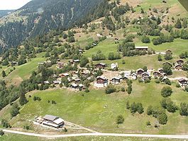
Country Switzerland 
Canton Valais District Raron 46°23′N 8°5′E / 46.383°N 8.083°ECoordinates: 46°23′N 8°5′E / 46.383°N 8.083°E Population 22 (Dec 2009)[1] - Density 7 /km2 (19 /sq mi) Area 3.0 km2 (1.2 sq mi) Elevation 1,367 m (4,485 ft) Postal code 3994 SFOS number 6178 Surrounded by Betten, Grengiols, Lax Website Martisberg.ch
SFSO statistics
 Martisberg
View map of Martisberg Martisberg is a municipality in the district of Raron in the canton of Valais in Switzerland.
Contents
History
Martisberg is first mentioned in 1311 as Martisperg.[2]
Geography
Martisberg has an area, as of 2011[update], of 3 square kilometers (1.2 sq mi). Of this area, 42.2% is used for agricultural purposes, while 41.2% is forested. Of the rest of the land, 3.7% is settled (buildings or roads) and 13.0% is unproductive land.[3]
The municipality is located in the Östlich Raron district, on the northern slopes of the Rhone valley.
Coat of arms
The blazon of the municipal coat of arms is Or a Sword Azure hilted Sable inverted in bend sinistre covered with a cloth Gules in base Coupeaux Vert[4]
Demographics
Martisberg has a population (as of December 2009[update]) of 22.[1] As of 2008[update], about 9.1% of the population are resident foreign nationals.[5] Over the last 10 years (2000–2010 ) the population has changed at a rate of -26.7%. It has changed at a rate of 0% due to migration and at a rate of -20% due to births and deaths.[3]
All of the population (as of 2000[update]) speaks German.[6]
As of 2008[update], the population was made up of 20 Swiss citizens.[5] Of the population in the municipality, 23 or about 85.2% were born in Martisberg and lived there in 2000. There were 4 or 14.8% who were born in the same canton but not in Martisberg.[6]
As of 2000[update], children and teenagers (0-19 years old) make up 25.9% of the population, while adults (20-64 years old) make up 48.1% and seniors (over 64 years old) make up 25.9%.[3]
As of 2000[update], there were 13 people who were single and never married in the municipality. There were 12 married individuals and 2 widows or widowers.[6]
As of 2000[update], there were 13 private households in the municipality, and an average of 2.1 persons per household.[3] There were 7 households that consist of only one person and households with five or more people. In 2000[update], a total of 13 apartments (32.5% of the total) were permanently occupied, while 21 apartments (52.5%) were seasonally occupied and 6 apartments (15.0%) were empty.[7]
The historical population is given in the following chart:[2][8]

Politics
In the 2007 federal election the most popular party was the CVP which received 70.68% of the vote. The next three most popular parties were the SP (14.29%), the FDP (9.02%) and the SVP (6.02%). In the federal election, a total of 19 votes were cast, and the voter turnout was 79.2%.[9]
In the 2009 Conseil d'Etat/Staatsrat election a total of 16 votes were cast, of which or about 0.0% were invalid. The voter participation was 94.1%, which is much more than the cantonal average of 54.67%.[10] In the 2007 Swiss Council of States election election a total of 14 votes were cast. The voter participation was 77.8%, which is much more than the cantonal average of 59.88%.[11]
Economy
As of 2010[update], Martisberg had an unemployment rate of 0%. As of 2008[update], there were 4 people employed in the primary economic sector and about 2 businesses involved in this sector. No one was employed in the secondary sector or the tertiary sector.[3] There were 12 residents of the municipality who were employed in some capacity, of which females made up 25.0% of the workforce.
In 2008[update] the total number of full-time equivalent jobs was 2, both in agriculture.[12]
In 2000[update], there were 8 workers who commuted away from the municipality.[13] Of the working population, 8.3% used public transportation to get to work, and 66.7% used a private car.[3]
Religion
From the 2000 census[update], 26 or 96.3% were Roman Catholic and there was 1 individual who belonged to another church.[6]
Education
In Martisberg about 8 or (29.6%) of the population have completed non-mandatory upper secondary education.
As of 2000[update], there were 5 students from Martisberg who attended schools outside the municipality.[13]
References
- ^ a b Swiss Federal Statistical Office, MS Excel document – Bilanz der ständigen Wohnbevölkerung nach Kantonen, Bezirken und Gemeinden (German) accessed 25 August 2010
- ^ a b Martisberg in German, French and Italian in the online Historical Dictionary of Switzerland.
- ^ a b c d e f Swiss Federal Statistical Office accessed 04-October-2011
- ^ Flags of the World.com accessed 04-October-2011
- ^ a b Swiss Federal Statistical Office - Superweb database - Gemeinde Statistics 1981-2008 (German) accessed 19 June 2010
- ^ a b c d STAT-TAB Datenwürfel für Thema 40.3 - 2000 (German) accessed 2 February 2011
- ^ Swiss Federal Statistical Office STAT-TAB - Datenwürfel für Thema 09.2 - Gebäude und Wohnungen (German) accessed 28 January 2011
- ^ Swiss Federal Statistical Office STAT-TAB Bevölkerungsentwicklung nach Region, 1850-2000 (German) accessed 29 January 2011
- ^ Swiss Federal Statistical Office, Nationalratswahlen 2007: Stärke der Parteien und Wahlbeteiligung, nach Gemeinden/Bezirk/Canton (German) accessed 28 May 2010
- ^ Staatsratswahlen vom 1. März 2009 (German) accessed 24 August 2011
- ^ Ständeratswahl 2007 (German) accessed 24 August 2011
- ^ Swiss Federal Statistical Office STAT-TAB Betriebszählung: Arbeitsstätten nach Gemeinde und NOGA 2008 (Abschnitte), Sektoren 1-3 (German) accessed 28 January 2011
- ^ a b Swiss Federal Statistical Office - Statweb (German) accessed 24 June 2010
Betten | Bister | Bitsch | Grengiols | Martisberg | Mörel-Filet | Riederalp
Valais | Districts of Canton Valais | Municipalities of the canton of Valais
 Categories:
- Municipalities of Valais
- Municipalities of Switzerland


Wikimedia Foundation. 2010.