- Holosiivskyi Raion
Infobox Settlement
settlement_type =
subdivision_type = Country
subdivision_name = UKR
subdivision_type1 =Oblast
subdivision_name1 =Kiev City Municipality
timezone=EET
utc_offset=+2
timezone_DST=EEST
utc_offset_DST=+3
official_name = Holosiivs’kyi Raion
native_name = Голосіївський район
area_total_km2 = 156.35
population_total = 205300|population_footnotes=
population_density_km2 = 1311
leader_title=Mayor
leader_name= Tetyana G. Strokan
blank_name=Landmarks |blank1_name=Metro stations
blank_info =National Expocenter of Ukraine , Museum of Folk Architecture and Life
blank1_info = Lybidska, Ukraina Palace, Respublikansky Stadion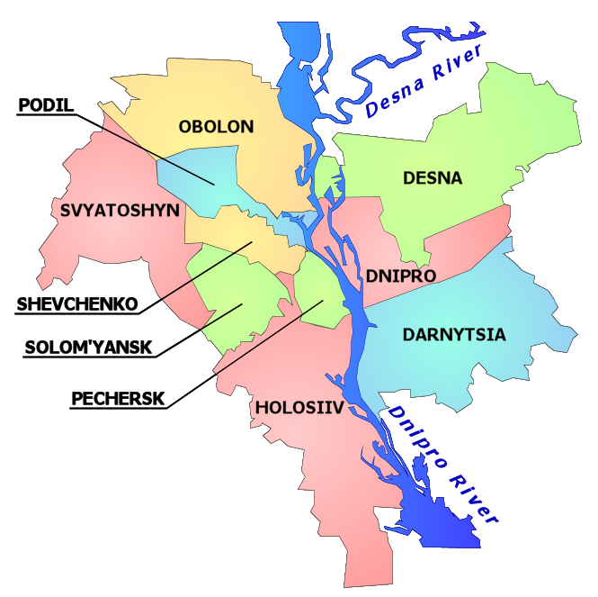
image_shield = Coat of Arms of Holosiivskyi Raion.gif
website = golosiiv.kyiv-city.gov.uaHolosiivskyi Raion ( _uk. Голосіївський район, translit.: "Holosiivs’kyi raion") is a administrative raion (district) of the city of
Kiev , the capital ofUkraine .Holosiivskyi Raion was created as part of a change in the administrative divisions of the capital of Ukraine, which was conducted in September 2001, as per the decision of the
Kiev City Council onJanuary 1 ,2001 .Holosiivskyi Raion is located in the southwestern part of Kiev, bordering the Shevchenkivskyi, Solomianskyi,
Pechersk yi, and Darnytskyi raions of Kiev, and the Kyievo-Sviatoshynskyi, Obukhivskyi, and Boryspilskyi raions ofKiev Oblast .The territory of the raion begins from the famous
Khreschatyk street, and stretches toward the southwest of Kiev. With this, the raion is somewhat like the southwest entrance into the city. The raion consists of the following historical neighbourhoods of Kiev: Pankovschyna, Predslavyno, Yamky, Saperna Slobidka, Baikovo, Zabaikove, Demiivka, Shyrma, Tsymbalov Yar, Dobryi Put, Holosiiv,Feofaniya ,Lysa Hora , Bahrynova Hora, Myshelovka, Samburky, Kytaevo, Pirogovo, Tserkovschyna, Nyzhna Telychka, Korchevate, Vyta, and Vodnykiv Island.External links
* [http://www.golosiiv.kyiv-city.gov.ua/ golosiiv.kyiv-city.gov.ua] - Holosiivskyi Raion administration website uk icon/en icon
* [http://www.golosiyiv.kiev.ua/ golosiyiv.kiev.ua] - Holosiivskyi Raion portal uk icon
* [http://wek.kiev.ua/wiki/index.php/%D0%93%D0%BE%D0%BB%D0%BE%D1%81%D1%96%D1%97%D0%B2 Голосіїв] in [http://wek.kiev.ua/ "Wiki-Encyclopedia Kyiv"] uk icon
Wikimedia Foundation. 2010.