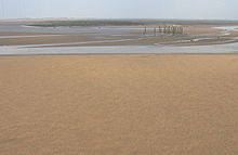
Moricambe Bay

Moricambe Bay
Moricambe Bay

Moricambe Bay is an inlet of the Solway Firth in Cumbria (before 1974 in Cumberland) in north west England, created by the confluence of two rivers, the Waver and Wampool.

External links

Coordinates: 54°54′02″N 3°18′41″W / 54.90064°N 3.31144°W / 54.90064; -3.31144


Wikimedia Foundation. 2010.

Игры ⚽ Поможем сделать НИР

Look at other dictionaries:

  • MORICAMBE — aestus et fluv. Albionis in parte Boreali Comitatus Cumbriae, inter Itunam et Belisamam amnes. The Bay of Cardronock, teste Camdenô. Baudrando est aestuarium parvum, ad ostia amnis Wampul, iuxta Itunae aestuarium, vix 4. milliar. Scoticis, a… …   Hofmann J. Lexicon universale

  • List of bays of the British Isles — This is a list of bays of the British Isles, geographically by island. They are listed by island, in clockwise order, from the stated starting point.BritainClockwise from the River Tweed:England from the River Tweed to the Bristol Channel*Budle… …   Wikipedia

  • River Wampool — The River Wampool is a river flowing through north western Cumbria in England.The river is formed at Chalkfoot near East Curthwaite, before which it is known as Chalk Beck.Chalk Beck rises close to Wavergillhead and runs north, meeting Iron Gill… …   Wikipedia

  • River Waver — The River Waver is a river in Cumbria, England. The river rises at Wavergillhead (as Townthwaite Beck).It is fed by the northwards flowing Thornthwaite Beck and Pow Gill either side of Bolton Wood Lane.The Little Waver , rising at Catlands Hill,… …   Wikipedia

  • Fleetwood — Infobox UK place official name= Fleetwood static static image caption= Fleetwood The Marine Hall and Gardens from the Mount country= England region= North West England population= 26,840 (2001 Census) os grid reference= SD333479 latitude= 53.923… …   Wikipedia

Share the article and excerpts

Direct link
Do a right-click on the link above
and select “Copy Link”