- Bowaters Paper Railway
Infobox rail|railroad_name=Bowaters Paper Railway
gauge=RailGauge|30
length=10 miles
start_year=1906
end_year=1969
hq_city=Sittingbourne
locale=England
system_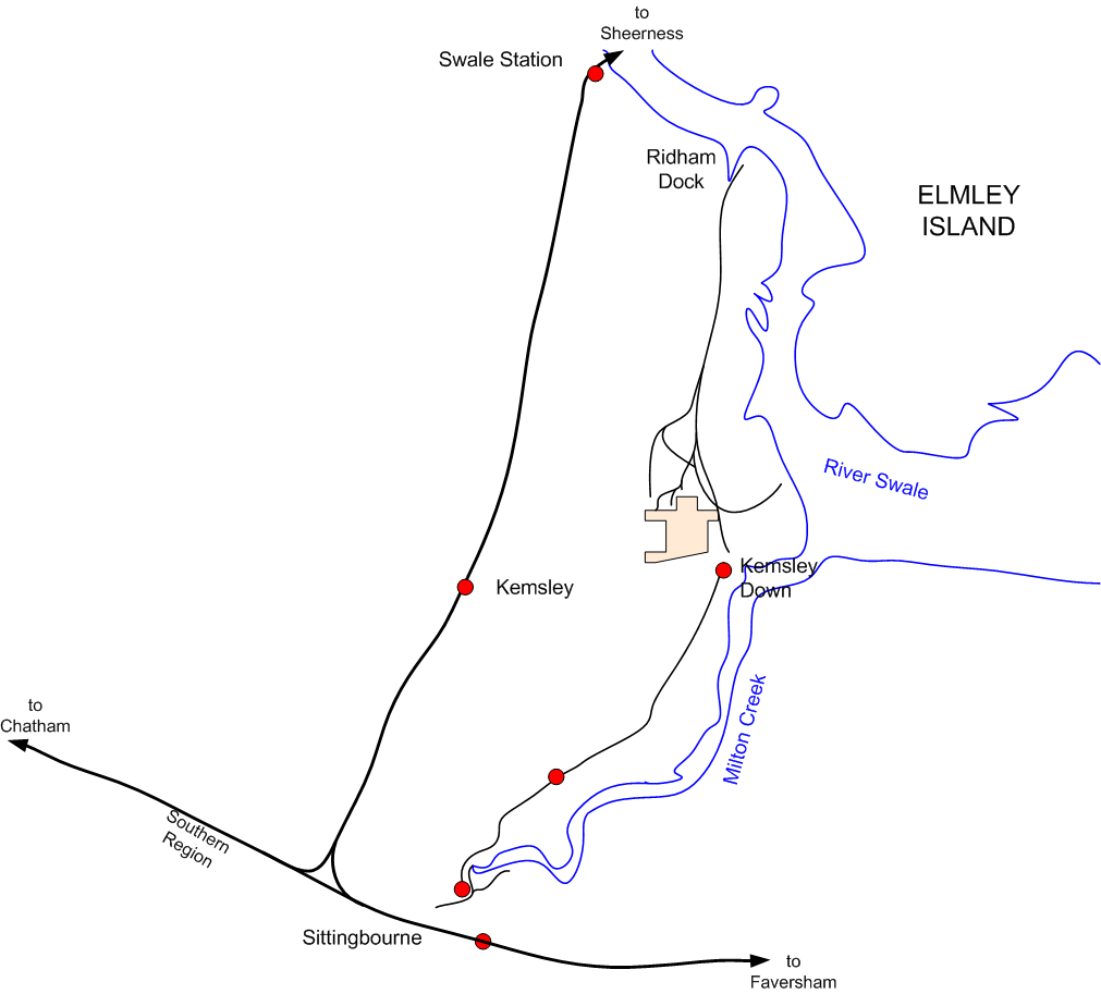
map_size=250px. It had the distinction of being the last steam-operated industrial narrow gauge railway in Britain when it closed in 1969.History
The manufacture of paper at Sittingbourne dates back to the 17th C. The paper mill was originally supplied with raw materials by barges that sailed to wharves at the head of Milton Creek. A short horse-hauled tramway moved pulp to the mill. Two steam locomotives were introduced in 1908.
In 1913, as Milton Creek began to silt up, the paper making company began work on the construction of Ridham Dock, a deepwater facility on the Swale estuary, where seagoing ships could unload raw materials and load finished paper products. At the start of WW I the railway and the dock was taken over by the Admiralty and the railway was extended to connect the dock. At the end of the war the railway was returned to the paper company. In 1924 a second paper mill opened at Kemsley Down and the railway reached its maximum length of 10 miles.
Closure, preservation and uncertain future
In 1969 a time and motion study by the then owners, Bowaters, resulted in the closure of the railway. By this time the railway was the last industrial narrow gauge railway in Britain operating steam locomotives. The
Locomotive Club of Great Britain (LCGB) was granted a lease of the southern portion of the railway between Sittingbourne and Kemsley Down in 1970. Much of the rest of the equipment went to form theGreat Whipsnade Railway . The LCGB formed the Sittingbourne and Kemsley Light Railway Company to operate the railway. The company operates the railway under the nameSittingbourne & Kemsley Light Railway (S&KLR).The S&KLR is in danger of closure at the end of 2008. The current owners of the railway land, the Finish paper company M-real, closed the paper mill at Sittingbourne in 2007cite web |url=http://www.m-real.com/wps/portal/OneWeb?New_WCM_Context=/ilwwcm/connect/OneWeb/About+us/At+a+glance/M-real+milestones
title=M-real milestones
publisher=M-real Corporation
accessdate=2008-08-31] and sold the paper mill at Kemsley to another company. M-real have also given the railway company notice to quit the site and to remove all their locomotives and equipment by the end of December 2008. [Citation
last =
first = Dyspozytor
author-link =
last2 =
first2 =
author2-link =
title = S&KLR only 4 months to go?
newspaper = Behind The Water Tower
pages =
year =
date =2008-08-27
url = http://polishrail.wordpress.com/2008/08/27/sklr-only-4-months-to-go/]Locomotives
ee also
*
British narrow gauge railways References
*
*
*External links
* [http://www.sklr.net/ Sittingbourne's Steam Railway] , Sittingbourne and Kemsley Light Railway Limited official website
Wikimedia Foundation. 2010.