- Alberti Partido
Infobox Partido Argentina
name= Alberti
official name= Partido de Alberti
coat of arms = Sin escudo.svg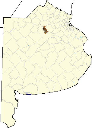
capital= Alberti
foundation=June 10 1910
founder= Andres Vaccarezza
pop= 10,322
density= 9.13 Inhabitants/km²
pop change= - 2,39 %(1991-2001)
resident= "albertino"
tel= 02346
post= B6634
coor= coord|35|02|S|60|15|W
area= 1,130 km² (436 sq mi)
dist1= 192 km (119 mi)
dist2 =
patron=
mayor= Leonel Omás Zacca, PJ
web= http://www.alberti.gov.ar
ifam= BUE003Alberti is a northern central partido of
Buenos Aires Province ,Argentina , at coordinates coord|35|02|S|60|15|WAlberti is located at the south of the
Gran Buenos Aires urban area. It has an area of 1,130 km² (436 sq mi) and 10,322 inhabitants (census-ar|2001).Economy
The economy of Alberti is dominated by agriculture. Its main products are
wheat ,maize ,soya bean s,oat s,sunflower s,sorghum , and industrial crops.Attractions
* Raúl Lozza Gallery of Contemporary Art, Alberti
* Parque Municipal (Municipal park), Albertiettlements
*Alberti (Capital) (7,493 inhabitants)
*Achupallas (112 inhabitants)
*Anderson
*Baudrix
*Villa Ortíz, Estación Coronel Mom (857 inhabitants)
*Coronel Seguí (148 inhabitants)
*Gobernador Ugarte
*Mechita (438 inhabitants)
*Larrea
*Emita
*Palantelén
*Plá (237 inhabitants)
*Presidente Quintana
*Villa Grisolía
*Villa María (21 inhabitants)External links
*es icon [http://www.alberti.gov.ar Official website]
*es icon [http://www.mininterior.gov.ar/municipales/busqueda/amplia_info.asp?ID=BUE003 Ministry of the Interior statistics]
Wikimedia Foundation. 2010.