- Musquodoboit Harbour, Nova Scotia
-
 Musquodoboit Harbour in Nova Scotia
- This article is about a community, for the natural harbour, see Musquodoboit Harbour.
Musquodoboit Harbour is a Canadian rural community in Nova Scotia's Halifax Regional Municipality. The community is situated on the Eastern Shore at the mouth of the Musquodoboit River. the community lies 45 kilometres east of downtown Halifax. With a hospital, RCMP detachment, postal outlet, schools, recreational center, library, municipal office and other services, Musquodoboit Harbour is a serve centre for many of the surrounding communities.
Musquodoboit means foaming to the sea. The community is an anglicized version of the Mi’kmaq word Moosekudoboogwek.
Contents
History
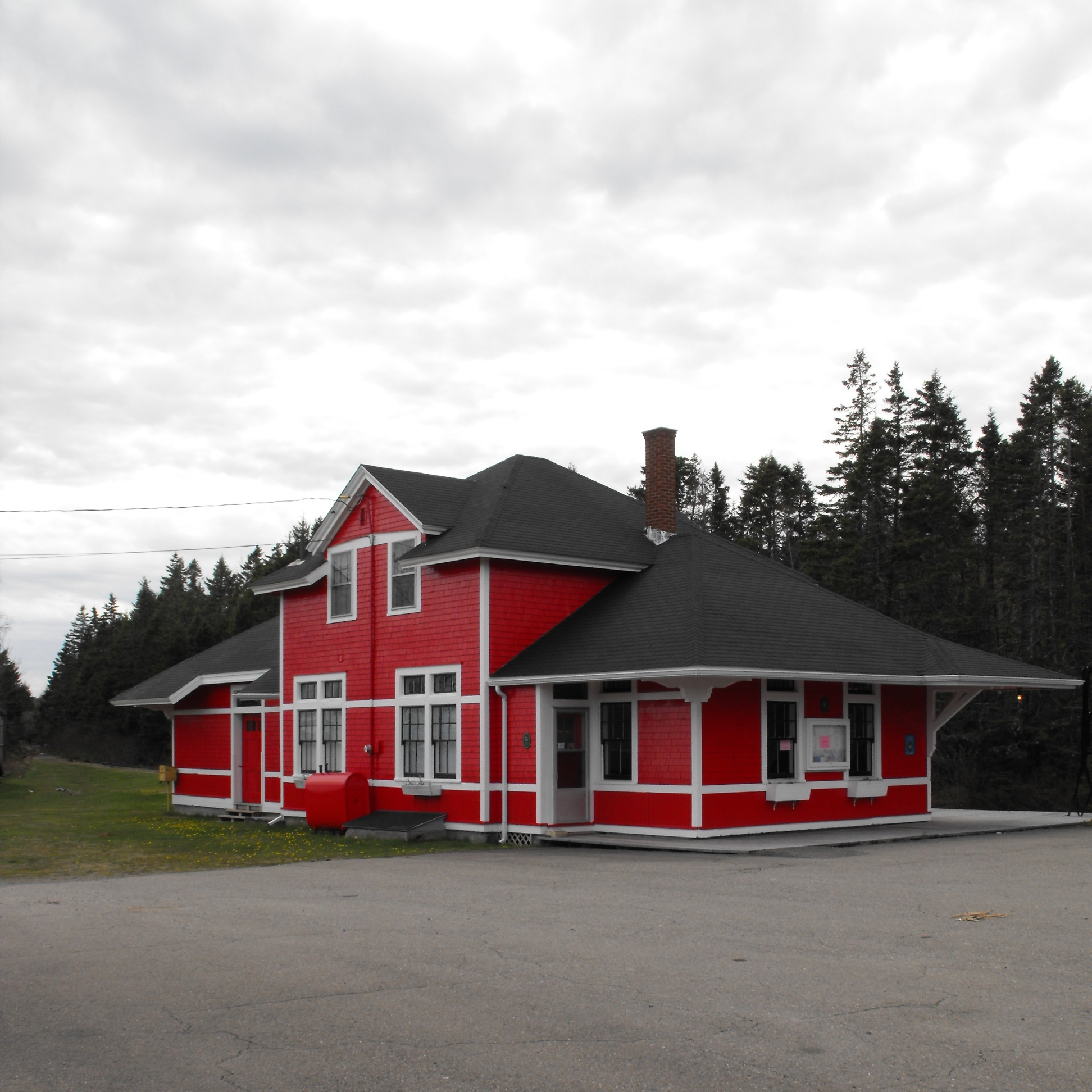
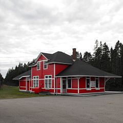 The local railway station is now a museum
The community was settled in the 1780s mainly by Loyalists. Through the late 18th and early 19th centuries many settlers from Scotland, England and Germany immigrated to the area and they still have descendents in the area, evidenced by prominent family names such as Rowlings, Anderson, and Bayers.
Transportation history
Much early travel was by water as roads were rough. Beginning in 1852, the stage coach travelled from Musquodoboit Harbour to Dartmouth and a trip cost 5 shillings. The first automobile was owned by Dr Kennedy in 1909. The Dartmouth Eastern Railway commenced in 1912 to carry lumber and lime from Middle Musquodoboit to Dartmouth. A station was completed in 1918 and today houses the Musquodoboit Harbour Railway Museum, which also serves as the local tourism office in summer. The museum grounds contain a passenger car, snow plow from the Dominion Atlantic Railway and a caboose from the Canadian National Railway. The museum is on the Canadian Register of Historic Places.[1]
Other services
The Rural Telephone system came into use around 1909.
The Fire Department
It all began one evening in 1957 when Garth Young was sitting at the table playing crib with friends. His sister ran in and said she could see flames in a window upstairs as she was driving down the road. Garth and his father each grabbed a bucket of water and ran upstairs, but there was nothing they could do.
There was no fire department in Musquodoboit Harbour. They called Lands and Forests (now called the Department of Natural Resources) who showed up later with a portable pump and some hose. But by now, the two story house was in flames and the dozen family members who lived there could only watch helplessly as it burned to the ground.
The loss motivated Garth Young and other people in the community to establish their own fire department.
By 1960 Garth Young was clearing land for the new station. A year later the Musquodoboit Harbour Volunteer Fire Department was born and he became one of its original members. The Musquodoboit Harbour Volunteer Fire Department formed in 1961 with the fire hall opening on October 6, 1964.
The first piece of equipment they had was a trailer with a pump on it. It had compartments on each side into which they were able to put extra equipment, such as hoses. The first truck they had was an old 1957 milk truck that they bought in 1963 from a farmer.
The Fire Department Ladies Auxiliary formed in February 1967.
In 1996, Halifax, Dartmouth, Bedford, and the County of Halifax amalgamated into what is today the Halifax Regional Municipality. Dozens of fire departments merged into the Halifax Regional Fire & Emergency Services, and the Musquodoboit Harbour Volunteer Fire Department received the designation of "Halifax Regional Fire & Emergency, Station 24".
On June 13, 2008, The station was actively involved in the Porter's Lake fire, one of the biggest forest fire in Nova Scotia's history. Members spent 5 days working side-by-side with the Department of Natural Resources.
On October 6, 2008, the station was manned with career staff for the very first time. From October 6, 2008 to December 31, 2008, the crew was made up of a career Lieutenant and a casual worker taken from the station's own volunteers. On january 1, 2009 the station was officially manned with career staff, Monday to Friday, from 7:00 am until 5:30 pm, with anywhere between 2 and 4 personnel, depending on the needs, although on paper, there are 5 of them.
Although at first some volunteers were a bit uneasy about having career staff at the station, mainly due to stories about poor relations between career and volunteers in general, the two groups grew fond of one another over time, and nowadays station 24 is a model when it comes to friendly and fruitful relationship between career staff and volunteers. We help one another, take decisions together, exchange training ideas, etc.
Martinique Beach
Located at the end of the East Petpeswick Road, Martinique Beach is the longest sandy beach in Nova Scotia. This 5 kilometre long beach is a provincial park which boasts both picnic and swimming facilities. The excellent surf conditions at Martinique Beach draw in surfers from all over.
There is a wildlife sanctuary adjacent to Martinique Beach. Canada Geese and Black Ducks can often be seen during migratory periods. There is even a protected nesting area for the Piping Plover, an endangered species.
Yacht Club
Not far down the East Petpeswick Road is Petpeswick Yacht Club. PYC is home to a learn-to-sail program and small marina. The yacht club hosts two annual regattas: the Shearwater to Petpeswick Race, a coastal race from Dartmouth to Petpeswick Inlet, and Mid Summer Regatta, a series of races for younger sailors in small boats.
Churches
- Jeddore Baptist Church
- Kingdom's Hall of Jehovah's Witnesses
- Marine Drive Pentecostal Church
- Musquodoboit Harbour Presbyterian Church
- St James Anglican Church Hall
- St. Phillip Neri Roman Catholic Church
- United Church of Canada, Musquodoboit Harbour
- St Thomas' Anglican Church, Musquodoboit Harbour
Transportation
Communications
- The postal Code is B0J 2L0.
- The Telephone exchange is 902 889 , 891 - Aliant; 342 - Eastlink; 878 - Rogers
Demographics
- Total Population - 2139
- Total Dwellings - 1364
- Total Land Area - 207.042 km²
Schools
- Eastern Shore District High School (10 to 12)
External links
- Musquodoboit Harbour Railway Museum
- Musquodoboit Trailways Association
- HRM Community Information Page
- Halifax Public Libraries - Musquodoboit Harbour Branch
- Petpeswick Yacht Club
- Eastern Shore Recreation Commission
- Explore HRM
- Eastern Shore Jr. Mariners Hockey Club
References
- ^ http://www.historicplaces.ca/visit-visite/affichage-display.aspx?id=5334 Canadian Register of Historic Places.
Coordinates: 44°47′14.34″N 63°8′55.42″W / 44.7873167°N 63.1487278°W
Categories:- General Service Areas in Nova Scotia
- Communities in the Halifax Regional Municipality

Wikimedia Foundation. 2010.