- Hurricane Florence (2006)
Infobox Hurricane
Name=Hurricane Florence
Type=hurricane
Year=2006
Basin=Atl
Image location=Hurricane Florence 2006.jpg
Bermuda on September 10
Formed=September 3, 2006
Dissipated=September 13, 2006
1-min winds=80
Pressure=974
Da
Inflated=0
Fatalities=None
Areas=Bermuda , Newfoundland,East Coast of the United States
Hurricane season=2006 Atlantic hurricane season Hurricane Florence was the first
Atlantic hurricane to produce hurricane force winds onBermuda sinceHurricane Fabian hit the island in September 2003.cite web|author=Hurricane Research Division|year=2008|title=Best Track of Atlantic tropical cyclones (1851–2007)|publisher=National Oceanic and Atmospheric Administration|accessdate=2008-05-23|url=http://www.aoml.noaa.gov/hrd/hurdat/easyhurdat_5107.html] The seventh tropical storm and second hurricane of the2006 Atlantic hurricane season , Florence developed from atropical wave in the tropicalAtlantic Ocean on September 3 and followed the track of aCape Verde-type hurricane . Due to unfavorable conditions, the system failed to organize initially, and as a result the storm grew to an unusually large size. After several days, Florence encountered an area of lesserwind shear and intensified into a hurricane on September 10. It passed just west ofBermuda while recurving northeastward, and on September 13 it transitioned into anextratropical cyclone .Florence produced wind gusts of up to 115 mph (185 km/h) on Bermuda, which caused several power outages and minor damage. Florence then brought heavy rains across Newfoundland as an
extratropical storm , destroying one house and causing minor damage to several others. There were no fatalities as a result of the hurricane.Meteorological history
A
tropical wave moved off the coast ofAfrica on August 29. It tracked slowly westward, and first showed signs of development two days later. On August 31, a second tropical wave exited the coast of Africa at a faster speed than its predecessor. The two waves interacted, and by September 2 combined to form a large area of disturbed weather across the easternAtlantic Ocean .cite web|author=Jack Beven|year=2006|title=Hurricane Florence Tropical Cyclone Report|publisher=National Hurricane Center|accessdate=2007-06-06|url=http://www.nhc.noaa.gov/pdf/TCR-AL062006_Florence.pdf]Convection increased within the system, [cite web|author=Brown & Knabb|year=2006|title=September 2 Tropical Weather Outlook|publisher=National Hurricane Center|accessdate=2007-06-06|url=ftp://ftp.met.fsu.edu/pub/weather/tropical/Outlook-A/2006090209.ABNT20] and it developed a concentrated area of convection in conjunction with a well-definedlow pressure area . [cite web|author=Stewart|year=2006|title=September 3 Tropical Weather Outlook|publisher=National Hurricane Center|accessdate=2007-06-06|url=ftp://ftp.met.fsu.edu/pub/weather/tropical/Outlook-A/2006090309.ABNT20] By late on September 3, the system maintained a broad closed circulation and enough convective organization to be classified Tropical Depression Six while located about midway between theLesser Antilles and Africa.cite web|author=Franklin|year=2006|title=Tropical Depression Six Discussion One|publisher=National Hurricane Center|accessdate=2007-06-06|url=http://www.nhc.noaa.gov/archive/2006/al06/al062006.discus.001.shtml]Upon becoming a tropical cyclone, the depression maintained multiple cloud swirls within a common center. Banding features increased, though southwesterly
wind shear and the lack of a well-defined circulation prevented initial strengthening.cite web|author=Rhome & Avila|year=2006|title=Tropical Depression Six Discussion Three|publisher=National Hurricane Center|accessdate=2007-06-07|url=http://www.nhc.noaa.gov/archive/2006/al06/al062006.discus.003.shtml] Dry air encountered the depression, and as such it developed very slowly; forecasters maintained considerable difficulty in determining a center of circulation. It continued its motion to the west-northwest while tracking around the southern periphery of a deep-layersubtropical ridge to its north.cite web|author=Stewart|year=2006|title=Tropical Depression Six Discussion Six|publisher=National Hurricane Center|accessdate=2007-06-09|url=http://www.nhc.noaa.gov/archive/2006/al06/al062006.discus.006.shtml] Though convection remained focused near the outer periphery of the system,cite web|author=Rhome & Avila|year=2006|title=Tropical Depression Six Discussion Seven|publisher=National Hurricane Center|accessdate=2007-06-09|url=http://www.nhc.noaa.gov/archive/2006/al06/al062006.discus.007.shtml] the overall organized continued to steadily increase, and it is estimated the depression intensified into Tropical Storm Florence on September 5 while located about 1,120 miles (1,800 km) east-northeast ofAnguilla .After attaining tropical storm status, the maximum sustained winds fluctuated for three days between 40 mph (65 km/h) and 50 mph (85 km/h). This was due to the large size of Florence; the overall wind field reached a diameter of 460 miles (745 km), and the radius of maximum winds reached about 110 miles (170 km).cite web|author=Stewart|year=2006|title=Tropical Storm Florence Discussion Eight|publisher=National Hurricane Center|accessdate=2007-06-09|url=http://www.nhc.noaa.gov/archive/2006/al06/al062006.discus.008.shtml] By September 6, a well-defined cloud swirl became evident, with thin rainbands developing in the southeast and northwest quadrants.cite web|author=Franklin|year=2006|title=Tropical Storm Florence Discussion Twelve|publisher=National Hurricane Center|accessdate=2007-06-09|url=http://www.nhc.noaa.gov/archive/2006/al06/al062006.discus.012.shtml] As a result, hurricane forecasters anticipated Florence would develop significantly and attain major hurricane status. Though convection gradually migrated closer to the center of the storm, forecasters could not detect a well-defined center of circulation by late on September 13.cite web|author=Franklin|year=2006|title=Tropical Storm Florence Discussion Thirteen|publisher=National Hurricane Center|accessdate=2007-06-09|url=http://www.nhc.noaa.gov/archive/2006/al06/al062006.discus.013.shtml] On September 7, convection developed over and to the west of the center for the first time in its duration. However, Florence failed to intensify further, as its wind field had increased to more than 1,035 miles (1,670 km) in diameter.cite web|author=Stewart|year=2006|title=Tropical Storm Florence Discussion Seventeen|publisher=National Hurricane Center|accessdate=2007-06-09|url=http://www.nhc.noaa.gov/archive/2006/al06/al062006.discus.017.shtml] This led to difficulties in forecasting, as its environment favored further strengthening; the storm tracked through an area of 84° F (29° C) water temperatures and light shear, and the system maintained a large low-level cyclonic envelop with abundant convection. By early on September 8, the storm consisted of an elongated, shapeless cloud pattern atypical of a tropical cyclone.cite web|author=Avila|year=2006|title=Tropical Storm Florence Discussion Eighteen|publisher=National Hurricane Center|accessdate=2007-06-09|url=http://www.nhc.noaa.gov/archive/2006/al06/al062006.discus.018.shtml] Later that day, as an
anticyclone developed over Florence, the storm began to consolidate around a vorticity center on the western side of the large cyclonic envelope. It began to strengthen more steadily as it turned to the northwest. Early on September 10, an eye began developing within a round central dense overcast over the center,cite web|author=Blake & Knabb|year=2006|title=Tropical Storm Florence Discussion Twenty-Six|publisher=National Hurricane Center|accessdate=2007-06-09|url=http://www.nhc.noaa.gov/archive/2006/al06/al062006.discus.026.shtml] and shortly thereafter Florence attained hurricane status while located about 390 miles (630 km) south ofBermuda .Hurricane Florence turned to the north and north-northeast through a break in the subtropical ridge. Though its eyewall was open on the north side, favorable conditions led forecasters to predict Florence passing near Bermuda as a strong Category 2 hurricane.cite web|author=Brown & Pasch|year=2006|title=Hurricane Florence Discussion Twenty-Eight|publisher=National Hurricane Center|accessdate=2007-06-09|url=http://www.nhc.noaa.gov/archive/2006/al06/al062006.discus.028.shtml] The inner core of convection became ragged-looking on satellite imagery, and based on reports from
Hurricane Hunters it is estimated the hurricane attained peak winds of 90 mph (150 km/h) late on September 10.cite web|author=Brown & Pasch|year=2006|title=Hurricane Florence Discussion Twenty-Nine|publisher=National Hurricane Center|accessdate=2007-06-09|url=http://www.nhc.noaa.gov/archive/2006/al06/al062006.discus.029.shtml] Subsequent to further erosion of the eyewall, the hurricane weakened, and on September 11 passed about 60 miles (95 km) west of Bermuda with winds of 85 mph (135 km/h). The overall cloud pattern became slightly better organized, and Florence briefly re-strengthened before encountering increased upper-level winds and cooler waters. Dry air wrapping around the southern periphery of the cyclone eroded most of the deep convection by early on September 12. The cloud shield became asymmetrically displaced to the north of the center, and frontal-like features began to form.cite web|author=Rhome & Franklin|year=2006|title=Hurricane Florence Discussion Thirty-Five|publisher=National Hurricane Center|accessdate=2007-06-09|url=http://www.nhc.noaa.gov/archive/2006/al06/al062006.discus.035.shtml] It continued to lose tropical characteristics, and on September 13 Florence transitioned into anextratropical cyclone about 485 miles (780 km) south-southwest ofCape Race , Newfoundland. Initially maintaining hurricane-force winds, the extratropical remnant passed near Cape Race before turning to the east-northeast, and on September 14 the winds weakened to gale force. The storm executed a broad cyclonic half-loop to the southwest ofIceland over the subsequent days, and after turning to the west the extratropical remnants of Florence were absorbed to the east ofGreenland by a developing extratropical cyclone to its south.Preparations
The government of
Bermuda issued a hurricane watch for the island on September 8,cite web|author=Avila|year=2006|title=Tropical Storm Florence Public Advisory Twenty-One|publisher=NHC|accessdate=2006-09-08|url=http://www.nhc.noaa.gov/archive/2006/al06/al062006.public.021.shtml?] which was followed by a tropical storm warning on September 9.cite web|author=Stewart|year=2006|title=Tropical Storm Florence Public Advisory Twenty-Four|publisher=NHC|accessdate=2006-09-09|url=http://www.nhc.noaa.gov/archive/2006/al06/al062006.public.024.shtml?] These were replaced by a hurricane warning on September 10, coinciding with the storm's strengthening to hurricane intensity.cite web|author=Franklin/Mainelli|year=2006|title=Hurricane Florence Public Advisory Twenty-Seven|publisher=NHC|accessdate=2006-09-10|url=http://www.aoml.noaa.gov/general/lib/lib1/nhclib/mwreviews/1936.pdf] The government urged the potentially impacted citizens to take preparations for the storm, many of whom bought supplies at local hardware stores.cite web|author=AP|year=2006|title=Tropical storm Florence expected to veer toward Bermuda, away from U.S. coast|accessdate=2006-09-08|url=http://www.canada.com/topics/news/world/story.html?id=32eeac76-f1d9-456c-9169-23c3cb5fe609&k=84837] Residents installed storm shutters, while boat owners moved their yachts to safer locations.cite web|author=AP|year=2006|title=Florence Heads to Bermuda|accessdate=2006-09-09|url=http://www.forbes.com/technology/ebusiness/feeds/ap/2006/09/09/ap3004836.html] An emergency shelter was prepared on the island. Prior to the arrival of the storm, officials canceled bus and ferry service, and also closed all schools and government offices on the day of impact. TheBermuda International Airport was also closed. [cite web|author=Ewart F. Brown|year=2006|title=Address to the Country: Hurricane Florence|publisher=Office of the Deputy Premier of Bermuda|accessdate=2007-06-14|url=http://www.bermudatourism.com/skins/aqua/2006_Address_to_the_Country_Hurricane_Florence.PDF|format=PDF]Impact
Hurricane Florence produced strong swells and dangerous surf conditions along the northern
Lesser Antilles ,Virgin Islands ,Puerto Rico ,Hispaniola , andBermuda .cite web|author=Knabb/Landsea|year=2006|title=Tropical Storm Florence Public Advisory Twenty-Two|publisher=NHC|accessdate=2006-09-08|url=http://www.nhc.noaa.gov/archive/2006/al06/al062006.public.022.shtml?] Later in its duration, the tight pressure gradient between Florence and a high-pressure system over southeastern Canada produced strong winds and rough waves along theEast Coast of the United States .cite web|author=Brown & Pasch|year=2006|title=Hurricane Florence Discussion Thirty-Four|publisher=National Hurricane Center|accessdate=2007-06-09|url=http://www.nhc.noaa.gov/archive/2006/al06/al062006.discus.034.shtml] The hurricane also caused strong swells and rough ocean conditions, includingrip currents , in theBahamas andAtlantic Canada .cite web|author=Blake & Avila|year=2006|title=Hurricane Florence Public Advisory Thirty-Four|publisher=NHC|accessdate=2006-09-12|url=http://www.nhc.noaa.gov/archive/2006/al06/al062006.public.034.shtml?] InSouth Carolina , high waves produced severe beach erosion on several beaches. [cite web|author=National Climatic Data Center|year=2006|title=Event Report for South Carolina|accessdate=2008-03-11|url=http://www4.ncdc.noaa.gov/cgi-win/wwcgi.dll?wwevent~ShowEvent~633610][
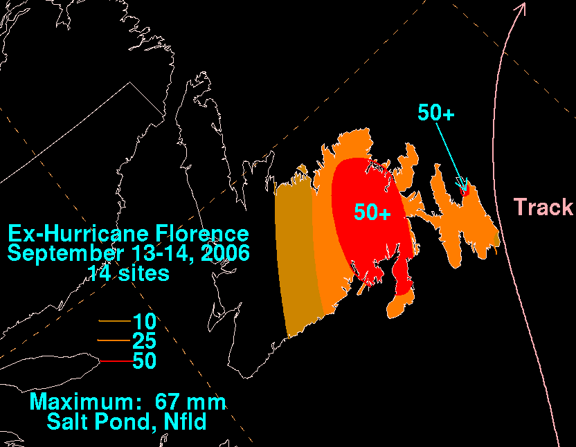
right|thumb|200px|Rainfall_totals_for_Florence_in_Newfoundland_(in_metric_units)
[http://www.hpc.ncep.noaa.gov/tropical/rain/florence2006filledrainblk.gifImperial units] ] Passing a short distance west ofBermuda , Hurricane Florence produced strong winds on the island; sustained winds peaked at 82 mph (132 km/h) on St. David's Island at an elevation of 410 feet (48 m), while gusts reached 115 mph (185 km/h) at the Maritime Operations Centre in St. George's Parish at an elevation of 665 feet (78 m). The winds knocked down trees and power lines, leaving over 25,000 homes and businesses without electricity during the peak of the storm.cite web|author=AP|year=2006|title=Hurricane Florence bashes Bermuda|accessdate=2006-09-11|url=http://www.reliefweb.int/rw/RWB.NSF/db900SID/KHII-6TK3WZ?OpenDocument] The powerful winds damaged ten houses, including destroying the roofs of three, and blew out windows across the island. A few people were injured by flying glass, though none required hospital care.cite web|author=Elizabeth Roberts|year=2006|title=Bermuda dodges Bermuda with no Injuries|publisher=AP|accessdate=2006-09-12|url=http://www.washingtonpost.com/wp-dyn/content/article/2006/09/12/AR2006091200682.html] Rainfall on the island reached 1.32 inches (34 mm) at theBermuda International Airport .A possible tornado in Southampton Parish downed trees and caused light property damage. At the Bermuda Zoo and Aquarium, two flamingos died due to falling branches. During the peak of the storm, police officials advised citizens to remain indoors away from harm, though there were several reports of looting throughout the territory.cite web|author=Matthew Taylor|year=2006|title=Florence causes little damage|publisher=Royal Gazette|accessdate=2006-09-11|url=http://www.theroyalgazette.com/apps/pbcs.dll/article?AID=/20060911/NEWS/109110145] The storm caused over $200,000 (2006 USD; $214,000 2008 USD) in damage on the island. [cite web|author=Tim Smith|year=2006|title=Florence-hit Surf Side nearly ready |publisher=The Royal Gazette|accessdate=2007-06-14|url=http://www.royalgazette.com/siftology.royalgazette/Article/article.jsp?sectionId=60&articleId=7d6bf13300300a3] Shortly after the storm passed through, BELCO began restoring power, and by six hours after the peak of the storm power had been restored to 7,000 homes and businesses. By the day after the storm, about 3,000 remained without electricity on the island.cite web|author=Reuters|year=2006|title=Bermuda back in business after brush with Florence|accessdate=2006-09-14|url=http://www.reliefweb.int/rw/RWB.NSF/db900SID/KHII-6TL7TV?OpenDocument&rc=2&emid=TC-2006-000135-BMU] The passage of the storm damaged the causeway between St. David's Island and Hamilton Parish, temporarily limiting traffic to one lane in each direction. [cite web|author=Matthew Taylor|year=2006|title=Hurricane Florence brushes past Island|publisher=The Royal Gazette|accessdate=2007-06-14|url=http://www.theroyalgazette.com/siftology.royalgazette/Article/article.jsp?sectionId=49&articleId=7d6cf1130030055]As an extratropical storm over Newfoundland, Florence produced powerful winds peaking at 101 mph (163 km/h) and moderate amounts of rainfall of up to 2.6 inches (67 mm).cite web|author=Fogarty/Boyer|year=2006|title=Post-Tropical Storm Information Statement|publisher=Canadian Hurricane Centre|url=http://www.atl.ec.gc.ca/weather/hurricane/bulletins/20060914115805.Florence.txt.en] Flooding and power outages were reported, although they were isolated. The hurricane caused flight interruptions at
St. John's International Airport and also to the Trans Canada ferry between Newfoundland andCape Breton Island in easternNova Scotia . [cite web|author=CBC News|date=2006-09-13|url=http://www.cbc.ca/canada/newfoundland-labrador/story/2006/09/13/florence-arrives.html|title=South coast of Newfoundland bears brunt of Florence|accessdate=2008-05-10] Strong winds destroyed a house in the small Newfoundland village of Francois. Residents in Francois agreed to rebuild the wrecked home while the family temporarily resided in a summer home of another family.cite news|author=CBC News|year=2006|title=Outport rallies after storm destroys family home|publisher =Canadian Broadcasting Corporation |date=2006-09-14 |accessdate=2006-09-20|url=http://www.cbc.ca/canada/newfoundland-labrador/story/2006/09/14/francois-house.html] The winds also caused damage to shingles and sides of homes, while the strong waves damaged roads and boats along theBurin Peninsula .ee also
*
List of Atlantic hurricanes References
External links
Wikinewshas|related news|
** NHC's [http://www.nhc.noaa.gov/archive/2006/FLORENCE.shtml? archive on Hurricane Florence]
* HPC's [http://www.hpc.ncep.noaa.gov/tropical/rain/florence2006.html rainfall page for Florence]
* CHC's [http://www.atl.ec.gc.ca/weather/hurricane/bulletins_e.html#2006:Florence archive on Hurricane Florence]


Wikimedia Foundation. 2010.