- Glarus Alps
Geobox|Range
name=Glarus Alps
other_name= _fr. Alpes glaronaises
other_name1= _de. Glarner Alpen

image_caption=Tödi
country=Switzerland
region_type=Cantons
region=Glarus| region1=Uri | region2=Graubünden
region3=St Gallen
unit=Alps
border=Urner Alps|border1=Lepontine Alps|border2=Appenzell Alps
length_imperial=| length_orientation=
width_imperial= | width_orientation=
geology= | period= | orogeny=
highest=Tödi
highest_elevation=3614
highest_lat_d=46|highest_lat_m=48|highest_lat_s=40|highest_lat_NS=N
highest_long_d=8|highest_long_m=54|highest_long_s=53|highest_long_EW=E
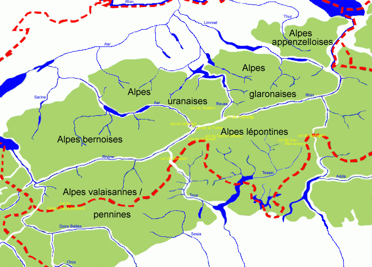
map_caption=Central Alps (the Glarus Alps are marked as "Alpes glaronaises")The Glarus Alps are a
mountain range in centralSwitzerland . They extend from theOberalp Pass to theKlausen Pass , and are bordered by theUrner Alps to the west, theLepontine Alps to the south and theAppenzell Alps to the north-east. The eastern part of the Glarus Alps contains a majorthrust fault which was declared a geologicUNESCO world heritage site (theSwiss Tectonic Arena Sardona ).Principal summits
Name Elevation Tödi 3614 meters 11,857 feet Bifertenstock 3426 meters 11,241 feet Piz Urlaun 3371 meters 11,060 feet Oberalpstock 3330 meters 10,926 feet Gross Schärhorn 3296 meters 10,814 feet Claridenstock 3270 meters 10,729 feet Düssi 3256 meters 10,703 feet Ringelspitz 3251 meters 10,667 feet Cavistrau 3250 meters 10,663 feet Gross Windgällen 3192 meters 10,473 feet Hausstock 3152 meters 10,342 feet Gross Ruchen 3136 meters 10,289 feet Piz Segnas 3102 meters 10,178 feet Piz Giuv 3098 meters 10,165 feet Crispalt 3080 meters 10,105 feet Bristen 3074 meters 10,086 feet Selbsanft 3029 meters 9,938 feet Bündner Vorab 3025 meters 9,925 feet Glärnisch 2914 meters 9,560 feet Tschingelhorner Elm 2850 meters 9,351 feet Piz Sol Grauehorner 2849 meters 9,348 feet Calanda 2808 meters 9,213 feet Kärpf 2797 meters 9,177 feet Magerrain 2528 meters 8,294 feet Mürtschenstock 2442 meters 8,012 feet Passes
The chief passes of the Tödi Range, from the
Oberalp Pass to theKlausen Pass , are::"Note: road status as of|1911|lc=on."
Mountain pass Location Type (as of 1911) Elevation Clariden Pass Amsteg toLinthal snow 2969 meters 9741 feet Planura Pass Amsteg to Linthal snow 2940 meters 9646 feet Kammlilucke or Scheerjoch Maderanertal toUnterschächen snow 2848 meters 9344 feet Sardona Pass Flims toBad Ragaz snow 2840 meters 9318 feet Sand Alp Pass Disentis toLinthal snow 2780 meters 9121 feet Brunni Pass Disentis toAmsteg snow 2736 meters 8977 feet Segnes Pass Elm to Flims foot path 2625 meters 8613 feet Kisten Pass Linthal toIlanz bad bridle path 2500 meters 8203 feet Panixer Pass Elm to Ilanz bad bridle path 2407 meters 7897 feet Chrüzli Pass Amsteg toSedrun foot path 2350 meters 7710 feet Foo or Ramin Pass Elm to Weisstannen bridle path 2222 meters 7290 feet Oberalp Pass Andermatt toDisentis carriage road 2048 meters 6719 feet Klausen Pass Altdorf to Linththal carriage road 1952 meters 6404 feet ee also
*
Swiss Alps External links
* [http://www.summitpost.org/area/range/170954/glarus-alps.html The Glarus Alps on SummitPost]
References
*1911
Wikimedia Foundation. 2010.