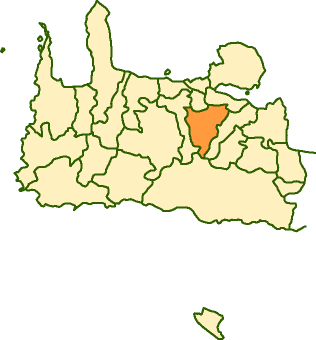
- Keramia
Infobox Greek Dimos
name = Keramia
name_local = Κεραμιά
periph =Crete
prefec = Chania
population = 1630
population_as_of = 2001
area =
elevation =
lat_deg = 35
lat_min = 25
lon_deg = 24
lon_min = 2
postal_code = 731 00
area_code = 28210
licence = ΧΝ, XB
mayor = Emmanouil Stratoudakis
website = [http://www.chania.gr/dimoishow.jsp?lang=en&id=13 Keramia Website]
caption_skyline =
city_
city_
districts =
party =
since =
elevation_min =
elevation_max =Keramia or Keramies ( _el. Κεραμιά, Δήμος Κεραμιών) is a municipality in the west of the island of
Crete ,Greece . It is part of theKydonia province which covers the centre ofChania Prefecture .Keramia covers the high villages in the foothills of the White Mountains ("
Lefka Ori ") to the south of the city ofChania . Though apparently close to Chania, the access to the villages of Keramia is by narrow winding hill roads, and hence the area is little developed or visited by tourists.The head town of the municipality is
Gerolakos . The municipality also includes Malaxa,Katohori ,Kontopoula andDrakonas .ee also
*
List of communities of Chania External links
* [http://www.chania.gr/dimoishow.jsp?lang=en&id=13 Municipality description]
* [http://www.gtp.gr/LocPage.asp?id=695 GTP description]
Wikimedia Foundation. 2010.
