- Montegabbione
-
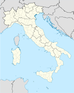
Montegabbione — Comune — Comune di Montegabbione Location of Montegabbione in Italy Coordinates: 42°55′N 12°5′E / 42.917°N 12.083°ECoordinates: 42°55′N 12°5′E / 42.917°N 12.083°E Country Italy Region Umbria Province Province of Terni (TR) Area - Total 51.3 km2 (19.8 sq mi) Elevation 594 m (1,949 ft) Population (Dec. 2004) - Total 1,270 - Density 24.8/km2 (64.1/sq mi) Demonym Montegabbionesi Time zone CET (UTC+1) - Summer (DST) CEST (UTC+2) Postal code 05010 Dialing code 0763 Website Official website Montegabbione is a comune (municipality) in the Province of Terni in the Italian region Umbria, located about 35 km southwest of Perugia and about 60 km northwest of Terni. As of 31 December 2004, it had a population of 1,270 and an area of 51.3 km².[1]
Montegabbione borders the following municipalities: Fabro, Ficulle, Monteleone d'Orvieto, Parrano, Piegaro, San Venanzo.
Demographic evolution

References
External links
Umbria · Comuni of the Province of Terni Acquasparta · Allerona · Alviano · Amelia · Arrone · Attigliano · Avigliano Umbro · Baschi · Calvi dell'Umbria · Castel Giorgio · Castel Viscardo · Fabro · Ferentillo · Ficulle · Giove · Guardea · Lugnano in Teverina · Montecastrilli · Montecchio · Montefranco · Montegabbione · Monteleone d'Orvieto · Narni · Orvieto · Otricoli · Parrano · Penna in Teverina · Polino · Porano · San Gemini · San Venanzo · Stroncone · TerniCategories:- Cities and towns in Umbria
- Communes of the Province of Terni
- Umbria geography stubs
Wikimedia Foundation. 2010.

