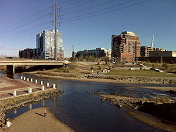
Confluence Park

Confluence Park
Confluence Park
}}
Confluence of the South Platte and Cheery Creek near downtown Denver
Type Urban Park
Location Denver, Colorado
Coordinates 39°45′11″N 105°00′42″W / 39.752997°N 105.011766°W / 39.752997; -105.011766Coordinates: 39°45′11″N 105°00′42″W / 39.752997°N 105.011766°W / 39.752997; -105.011766
Operated by City of Denver
Open Year round

Confluence Park is an urban park encompassing the confluence of Cherry Creek and the South Platte River in Denver's Lower Downtown (LoDo), a bustling neighborhood of 19th-century brick warehouses and storefronts that has been redeveloped since the late 1980s.

Current Usage

The park includes cement trails often filled with walkers, runners, and bikers. Some grassy areas, river overlooks, and park benches are also available. Two pedestrian bridges cross the South Platte River and Cherry Creek at Confluence Park. The eastern edge of the South Platte in Confluence Park has been transformed into a kayak run, immediately across from R.E.I.'s (Recreational Equipment Inc.) Colorado flagship store. The park is adjacent to a number of new up-scale townhouses, apartments, and loft developments, another park bordering the South Platte downstream, train tracks, and Denver's skatepark. The park is scheduled for major renovations in 2007, according to the Cherry Creek News.

On warm Thursday and Sunday nights, fire performers and drummers practice fire spinning to the sounds of a drum circle by the water. [1][2]

History

Confluence park marks the area where gold was discovered in 1858 by William Greeneberry Russell. This gold discovery led to the founding of Denver. Part of the site was previously an Xcel Energy substation that was relocated to allow for the expansion of the park.[3]

References

Confluence Park Denver - Lovely Denver

  1. ^ http://www.cnn.com/video/#/video/offbeat/2007/09/17/cole.co.fire.dancing.kusa
  2. ^ http://flickr.com/photos/gamp/sets/72157602131096539/ photoset on flickr
  3. ^ Denver Neighborhoods - Profile of Cherry Creek Neighborhood in Denver - Denver, CO

Wikimedia Foundation. 2010.

Игры ⚽ Нужно сделать НИР?

Look at other dictionaries:

  • Confluence Park — 39° 45′ 11″ N 105° 00′ 42″ W / 39.752997, 105.011766 …   Wikipédia en Français

  • Confluence Project — See Degree Confluence Project for the quest to find the intersections of whole number latitude and longitude. The Confluence Project is a series of outdoor installations and interpretive artworks located in public parks along the Columbia River… …   Wikipedia

  • Confluence Greenway — The Confluence Greenway is a 200 square mile (520 km2) system of parks, conservation and recreation areas located in the St. Louis, Missouri metropolitan area. Various parks, trails, and attractions are located along forty miles of both the… …   Wikipedia

  • Confluence, Pennsylvania — For other uses, see Confluence (disambiguation). Confluence, Pennsylvania   Borough   …   Wikipedia

  • Confluence Trail — The Confluence Trail, part of the Madison County, Illinois Transit (MCT) bikeways network, is an 18.6 mile bike trail between Granite City and Alton, Illinois s Russell Commons Park. The majority of the trail is paved asphalt on top of the… …   Wikipedia

  • Tablas de Daimiel National Park — ▪ park, Spain       nature reserve and wetland ecosystem, located about 19 miles (30 km) northeast of the city of Ciudad Real, south central Spain. The park, created in 1973, occupies 4,633 acres (1,875 hectares) and lies at the confluence of the …   Universalium

  • Jones-Confluence Point State Park — is a Missouri state park located on the north side of the Missouri River at its confluence with the Mississippi River, approximately 8 miles north of the St. Louis Arch. The park was opened May 9, 2004, and includes 1,118 acres (4.5 km sup2;) of… …   Wikipedia

  • Fall Creek Falls State Park — Infobox park park=Fall Creek Falls State Park image size=200px caption= type=Tennessee State Park location=Pikeville, Tennessee coordinates= size=convert|20000|acre|km2 opened=1935 operator=Tennessee Department of Environment and Conservation… …   Wikipedia

  • National Register of Historic Places listings in Capitol Reef National Park — This is a list of the National Register of Historic Places listings in Capitol Reef National Park. This is intended to be a complete list of the properties and districts on the National Register of Historic Places in Capitol Reef National Park,… …   Wikipedia

  • Shikellamy State Park — Geobox Protected Area name = Shikellamy State Park native name = other name = other name1 = category local = Pennsylvania State Park category iucn = III image caption = The entrance to Shikellamy State Park s scenic overlook etymology type =… …   Wikipedia

Share the article and excerpts

Direct link
Do a right-click on the link above
and select “Copy Link”