Northavon

Northavon

Coordinates: 51°36′14″N 2°31′05″W / 51.604°N 2.518°W / 51.604; -2.518

Northavon
Motto: Fides in Cives (Faithfulness towards our fellow citizens)
Northavon District within the County of Avon
Geography
Status non-metropolitan district
1974 area 114,028 acres (461.45 km2)[1]
HQ Thornbury
History
Created 1974
Abolished 1996
Succeeded by South Gloucestershire
Demography
1973[2] population 110, 620
1992[3] population 135,700
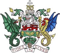
The arms of Northavon District Council

Northavon was a district in the English county of Avon from 1974 to 1996.

The district was formed by the Local Government Act 1972 on 1 April 1974 as part of a reform of local authorities throughout England and Wales. Under the reorganisation, the area surrounding the cities of Bath and Bristol was formed into a new county of "Avon", named after the river that ran through the area. The county was divided into six districts, one of which was formed from the areas of Sodbury Rural District (except the parish of Alderley) and most of Thornbury Rural District (16 out of 21 parishes) in Gloucestershire.[1] The name "Northavon" was invented in 1973, simply denoting the district's position in the county.

In 1991 the county boundaries of Avon and Gloucestershire were realigned. The main effect of the change was that the Hillesley and Tresham area was transferred from Northavon to the neighbouring District of Stroud in Gloucestershire.[4]

Following a review by the Local Government Commission for England, both the County of Avon and District of Northavon were abolished on 1 April 1996. Northavon was merged with the neighbouring Borough of Kingswood to form the unitary authority of South Gloucestershire.[5]

Northavon remains a parliamentary constituency, but will be split at the next general election (see List of Parliamentary constituencies in Avon).

References

  1. ^ a b Local government in England and Wales: A Guide to the New System. London: HMSO. 1974. p. 28. ISBN 978-0-11-750847-7. 
  2. ^ Registrar General's annual estimated figure mid 1973
  3. ^ OPCS Key Population and Vital Statistics 1992
  4. ^ "The Avon and Gloucestershire (County Boundaries) Order 1991". Office of Public Sector Information. 1991. http://www.opsi.gov.uk/si/si1991/uksi_19910271_en_1.htm. Retrieved 12 January 2009. 
  5. ^ "The Avon (Structural Change) Order 1995". Office of Public Sector Information. 1995. http://www.opsi.gov.uk/si/si1995/Uksi_19950493_en_1.htm. Retrieved 12 January 2009. 

Wikimedia Foundation. 2010.

Игры ⚽ Нужно сделать НИР?

Look at other dictionaries:

  • Northavon (UK Parliament constituency) — Coordinates: 51°36′14″N 2°31′05″W / 51.604°N 2.518°W / 51.604; 2.518 …   Wikipedia

  • Steve Webb — Infobox Politician honorific prefix = name =Steven John Webb honorific suffix = MP |200px caption = office = term start = term end = predecessor = successor = party = Liberal Democrats religion = constituency MP2 = Northavon majority2 = 11,033… …   Wikipedia

  • Avon (county) — Avon Avon shown within England Geography Status Non metropolitan county 1974 area …   Wikipedia

  • County of Avon — Das frühere County of Avon (1974 1996 Die Distrikte des County of Avon: 1. Northavon 2. Bristol 3. Kingswood 4. Woodspring 5. Wansdyke 6. Bath Das County of Avon war von 1974 bis 1996 eine Grafscha …   Deutsch Wikipedia

  • Yate — infobox UK place country = England official name= Yate latitude= 51.5402 longitude= 2.410989 civil parish= population = 21,789 unitary england= South Gloucestershire lieutenancy england= Gloucestershire DistrictType= region= South West England… …   Wikipedia

  • Kingswood, South Gloucestershire — infobox UK place country = England population= 62,679 (2001 Census) official name= Kingswood latitude= 51.4710 longitude= 2.5046 os grid reference= ST649748 unitary england= South Gloucestershire lieutenancy england= Gloucestershire region= South …   Wikipedia

  • Pucklechurch — is a village in South Gloucestershire, England, United Kingdom. Location Pucklechurch is located near the Bristol Ring Road (A4174). It is at the top of an escarpment, with fine views towards the Cotswolds, about four miles east. The village can… …   Wikipedia

  • List of District Health Authorities in England and Wales — District Health Authorities were administrative units of the National Health Service in England and Wales from 1982 to 1996. The districts were a second tier below the health regions. They replaced the Area Health Authorities (which generally… …   Wikipedia

  • Bristol — This article is about the British city. For other uses, see Bristol (disambiguation). Bristol   Unitary, Ci …   Wikipedia

  • Thornbury, South Gloucestershire — infobox UK place country = England latitude= 51.6094longitude= 2.5249official name= Thornbury population= 12,000 unitary england= South Gloucestershire lieutenancy england=Gloucestershire region= South West Englandconstituency westminster=… …   Wikipedia

Share the article and excerpts

Direct link
Do a right-click on the link above
and select “Copy Link”