- Kenora District, Ontario
Infobox Settlement
official_name = Kenora District
other_name =
native_name =
nickname =
settlement_type = District
motto =
imagesize =
image_caption =
flag_size =
image_
seal_size =
image_shield =
shield_size =
city_logo =
citylogo_size =
imagesize =
image_caption =
flag_size =
image_
seal_size =
image_shield =
shield_size =
city_logo =
citylogo_size =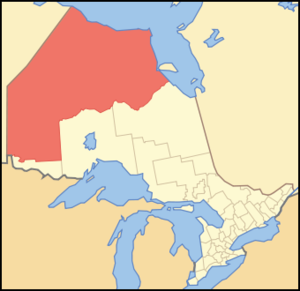
mapsize =
map_caption = Location of Kenora District in Ontario
mapsize1 =
map_caption1 =
image_dot_
dot_mapsize =
dot_map_caption =
dot_x = |dot_y =
pushpin_
pushpin_label_position =
pushpin_map_caption =
pushpin_mapsize =
subdivision_type = Country
subdivision_name =Canada
subdivision_type1 = Province
subdivision_name1 =Ontario
subdivision_type2 = Region
subdivision_name2 =Northwestern Ontario
subdivision_type3 =
subdivision_name3 =
subdivision_type4 =
subdivision_name4 =
government_footnotes =
government_type =
leader_title = MPs
leader_name =Roger Valley (LPC),Charlie Angus (NDP)
leader_title1 = MPPs
leader_name1 =Howard Hampton (NDP),Gilles Bisson (NDP)
leader_title2 =
leader_name2 =
leader_title3 =
leader_name3 =
leader_title4 =
leader_name4 =
established_title = Created
established_date = 1907
established_title2 =
established_date2 =
established_title3 =
established_date3 =
area_magnitude =
unit_pref =
area_footnotes =
area_total_km2 = 407192.56
area_land_km2 =
area_water_km2 =
area_total_sq_mi =
area_land_sq_mi =
area_water_sq_mi =
area_water_percent =
area_urban_km2 =
area_urban_sq_mi =
area_metro_km2 =
area_metro_sq_mi =
population_as_of = 2006
population_footnotes = [ [http://www12.statcan.ca/english/census06/data/profiles/community/Details/Page.cfm?Lang=E&Geo1=CD&Code1=3560&Geo2=PR&Code2=35&Data=Count&SearchText=kenora&SearchType=Begins&SearchPR=01&B1=All&Custom= Statcan 2006 Census Profile] ]
population_note =Canada 2006 Census
population_total = 64419
population_density_km2 = 0.2
population_density_sq_mi =
population_metro =
population_density_metro_km2 =
population_density_metro_sq_mi =
population_urban =
population_density_urban_km2 =
population_density_urban_sq_mi =
population_blank1_title =
population_blank1 =
population_density_blank1_km2 =
population_density_blank1_sq_mi =
timezone = Eastern (EST), Central (CST)
utc_offset = -5, -6
timezone_DST = Eastern Daylight (EDT), Central Daylight (CDT)
utc_offset_DST = -4, -5
latd= 49|latm= 46|lats= |latNS=N
longd= 94|longm= 29|longs= |longEW=W
elevation_footnotes = [Highest elevation from MapArt 2003 Edition Ontario Provincial Map - G4 south of Willard Lake.Hudson Bay is atMSL ]
elevation_m =MSL to 505m
elevation_ft = 0 to 1657
postal_code_type = Postal Code FSA
postal_code = P0V, P0X, P0Y, P8N, P8T, P9N
area_code = 807
blank_name = Largest communities [ [https://spreadsheets.google.com/pub?key=p-3CCzuDoD3NjJ2aGAOTbGA Compilation of Northwestern Ontario's 2006 census data] ]
blank_info = Kenora (15,177)
Dryden (8,195)
Sioux Lookout (5,183)
blank1_name =
blank1_info =
website =
footnotes =Kenora District (
Canada 2006 Census population 64,419) is adistrict andcensus division inNorthwestern Ontario in theCanadian province ofOntario . It was created in 1907 from parts of Rainy River District. It is, geographically, the largest division in that province; at 407,192.66 km² it comprises almost 38 percent of the province's land area. It is larger thanParaguay and approximately the size ofCalifornia .Kenora District also has the lowest
population density of any of Ontario's census divisions, although it ranks 38th out of 50 by population.The district seat is Kenora.
The northern part, north of the
Albany River and known sometimes as the Patricia Portion, became part of Ontario in 1912. It was originally designated as the separate Patricia District, but was added to the Kenora District in 1927.Politics
As with the other districts of Northern Ontario, Kenora District has no equivalent to the
county orregional municipality level of government that exists inSouthern Ontario . All government services in the district are instead provided by the local municipalities, by local service boards in some unincorporated communities, or directly by the provincial government.Geography
The
climate is very harsh because of the influence of the cold waters of Hudson and JamesBay s: most of the region istaiga characterised bydiscontinuous permafrost , but on the extreme northern coast there are - remarkably for a latitude of only 54°N - patches of true Arctictundra and continuous permafrost. This is the southernmost point reached by the circumpolar line of continuous permafrost on any continent.The Kenora District contains the
Sturgeon Lake Caldera , which is one of the world's best preservedNeoarchean caldera complexes and is some 2.7 billion years old. [ [http://www.d.umn.edu/~rmorton/ronshome/Volcanoes/calderas.html Caldera Volcanoes] Retrieved on2007-07-20 ]Economy
Most of the population of the district is concentrated in the extreme south where some
agriculture is possible: the main crop isbarley . In the north,mining is extremely extensive: northern Kenora district contains among the largest and highest-grade reserves ofuranium in the world, and is also one of the world's major producers ofnickel . Traditional native activities such as hunting and fishing dominate the northern half of the district outside of the few minings settlements.Transportation
Permanent
road s only reach about halfway to the northernmost point of Kenora district, with the provincial highway network ending at Pickle Lake, although some more northerly communities have access to a seasonalwinter road network. Year-round air and summertime river transport are the only means of reaching the most remote parts of the district. The majorrailroad betweenToronto andBritish Columbia passes through the south of the district.Patricia Portion
The Patricia Portion is an informal name for the part of the Kenora District lying north of the
Albany River , which was transferred from theNorthwest Territories to Ontario onMay 15 ,1912 in the Ontario Boundaries Extension Act, 1912. This area was originally a separate division named Patricia District, but became part of Kenora District in 1927.With the exception of a few communities along the northernmost ends of Highway 599 and the Highway 105/Highway 125 corridor, the Patricia Portion consists almost entirely of remote
First Nations communities which are only accessible byfloat plane orwinter road . Accordingly, the name "Patricia Portion" is still sometimes used to distinguish the area from the more populated southern portion of the district.Municipalities
* City of Dryden
* City of Kenora
* Municipality of Red Lake
* Municipality (town) of Sioux Lookout
* Township of Ear Falls
* Township of Ignace
* Township of Machin
* Township of Pickle Lake
* Township of Sioux Narrows-Nestor FallsIndian settlements
*Frenchman's Head
*Kejick Bay
*Lansdowne House
*MacDowell Lake
*Muskrat Dam
*Peawanuck
*Slate Falls
*Summer Beaver
*Webequie
*Whitefish BayIndian reserves
*Attawapiskat
*Bearskin Lake
*Cat Lake
*Deer Lake
*Eabametoong
*Eagle Lake 27
*English River 21
*Fort Albany 67 (part)
*Fort Severn 89
*Islington 29
*Kasabonika
*Keewaywin
*Kenora 38B
*Kingfisher Lake
*Kitchenuhmaykoosib Inninuwug
*Lac Seul
*Lake of the Woods 31G
*Lake of the Woods 37
*Marten Falls
*Mishkeegogamang
*Muskrat Dam Lake
*Neskantaga
*Northwest Angle 33
*North Spirit Lake
*Pikangikum
*Poplar Hill
*Rat Portage 38A
*Sabaskong Bay 35D
*Sachigo Lake
*Sandy Lake
*Shoal Lake 39A (part)
*Shoal Lake 40 (part)
*Shoal Lake 34B2
*The Dalles 38C
*Wabauskang 21
*Wabigoon Lake
*Wapekeka
*Wawakapewin
*Weagamow Lake 87
*Whitefish Bay 32A
*Whitefish Bay 33A
*Whitefish Bay 34A
*Wunnumin LakeUnorganized Areas
See also
*
List of Ontario Census Divisions References
Subdivisions of Ontario
Wikimedia Foundation. 2010.