- Omorate
-
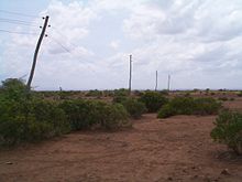 Abandoned powerlines near Omorate - part of the abandoned North Korean cotton plantation scheme
Omorate (also known as Kelem) is a town in southern Ethiopia near the Kenyan border.[1] Located in the Debub Omo Zone of the Southern Nations, Nationalities and Peoples' Region, this village has a latitude and longitude of 4°48′N 35°58′E / 4.8°N 35.967°ECoordinates: 4°48′N 35°58′E / 4.8°N 35.967°E with an elevation of 395 meters above sea level. It is the administrative center of Kuraz woreda.
Contents
History
Although during the Italian occupation there was an official in residence at Kelem (as it was known then), who encouraged the local Daasanach to resist and repulse an advance of 3,000 men of the King's African Rifles in early 1941, until the 1970s Omorate was little more than one of a handful of scattered police stations in this part of Ethiopia.[2]
In a more recent publication, although describing Omorate as an "archetypical tropical backwater", Philip Briggs notes that the village is "epitomised by the relics of the agricultural cotton scheme that was initiated with North Korean funds in the Mengistu era and faltered to a standstill more than a decade back. The retrenched victims of this aborted masterplan still haunt the bars of Omorate, willing to talk the ear off any stranger about their misfortune".[3]
Demographics
Based on figures from the Central Statistical Agency in 2005, Omorate has an estimated total population of 3363, of whom 1842 were males and 1521 were females.[4] The 1994 national census reported this town had a total population of 1,857 of whom 1,020 were males and 837 were females.
Notes
- ^ Geographical information based on "ETHIOPIA: Poor communication hampering flood response"(IRIN)
- ^ "Local History in Ethiopia" (pdf) The Nordic Africa Institute website (accessed 20 June 2008)
- ^ Briggs, Philip (2002). Ethiopia: the Bradt travel guide, Bradt travel guides, 3rd ed., Chalfont St. Peter: Bradt, p. 468 ISBN 1-84162-035-1
- ^ CSA 2005 National Statistics, Table B.4
External links
- Dassanech - The indigenous people of Omorate, from the BBC series Tribes
Categories:- Populated places in the Southern Nations, Nationalities, and People's Region

Wikimedia Foundation. 2010.