- King George Island
Infobox Islands
name = King George
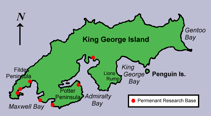
image caption = Map of King George Island, Antarctica
locator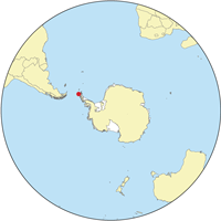
map_custom = no
nickname =
location =Antarctica
coordinates = coord|62|23|S|58|27|W|display=inline
archipelago =South Shetland Islands
total islands =
major islands =
area = convert|1150|km2|sqmi|0|abbr=on
length = convert|95|km|mi|0|abbr=on
width = convert|25|km|mi|0|abbr=on
highest mount =
elevation =
population =
population as of =
density =
ethnic groups =
country = Antarctica
additional info = Administered under theAntarctic Treaty System King George Island (Argentina: Isla 25 de Mayo, Chile: Isla Rey Jorge,
Russia n historical name - Vaterlo (Waterloo)) is the largest of theSouth Shetland Islands , situated at coord|62|23|S|58|27|W|, 120 kilometers off the coast ofAntarctica in theSouthern Ocean . The Island was named after King George III. It is not to be confused with King George Island, a small uninhabited island off South EasternTasmania , nor withGeorge Island in theFalkland Islands .The island was first claimed for Britain on
16 October 1819 , formally annexed by Britain and claimed as part of the Falkland Islands Dependencies in 1908, and now as part of the separateBritish Antarctic Territory . The Island was claimed byChile in 1940, now as part of theChilean Antarctic Territory . It was claimed also byArgentina in 1943, now as part ofArgentine Antarctica , called by the Argentines "Isla Veinticinco de Mayo" in honour of their National day. TheUSA andRussia do not recognize these claims, and have formally reserved their right to claim Antarctic territories.The island was discovered and named by the British explorer William Smith in 1819.Campbell, David G. (2002). "The Crystal Desert: Summers in Antarctica", p. 4. Houghton-Mifflin Books. ISBN 0618219218.] It is approximately 95 kilometres long and 25 kilometres wide with a land area of 1150 square kilometres. Over 90% of the island's surface is permanently glaciated. In 1821, 11 men of the sailing vessel "
Lord Melville " survived the winter on the island, the first men to do so inAntarctica . [Mills, William James (2003). "Exploring Polar Frontiers: A Historical Encyclopedia", p. 353. Santa Barbara: ABC-CLIO, Inc. ISBN 1576074226.]The coastal areas of the island are home to a comparatively diverse selection of
vegetation and animal life, including Elephant, Weddell and Leopard seals, and Chinstrap and Gentoo penguins.Human habitation of King George Island is limited to research stations belonging to
Argentina ,Brazil ,Chile ,China ,South Korea ,Peru ,Poland ,Russia , andUruguay . Most of these stations are permanently manned, carrying out research into areas as diverse asbiology ,ecology ,geology , andpalaeontology .In 2004, a Russian Orthodox church, Trinity Church, was opened on the island near Russia's
Bellingshausen Station . The church, one of the southernmost in the world and one of the few permanent structures in Antarctica, is permanently manned by a priest.A small amount of specialised
tourist activity also takes place during summer, including an annualmarathon , known as the Antarctic marathon.The Fildes Peninsula 7 km long (4.5 mi), forms the SW extremity of the island. It was named from association with nearby
Fildes Strait by theUK-APC in 1960.ee also
*
South Shetland Islands
*Sub-antarctic islands
*Henryk Arctowski Polish Antarctic Station
*Comandante Ferraz Brazilian Antarctic Base
*Chilean Antarctic Territory
*Islands of Chile
*Artigas Base Notes and references
* A.G.E. Jones, "Captain William Smith and the Discovery of New South Shetland", "Geographical Journal", Vol. 141, No. 3 (Nov., 1975), pp. 445-461
* Alan Gurney, "Below the Convergence: Voyages Toward Antarctica, 1699-1839", Penguin Books, New York, 1998External links
* [http://www.kgis.scar.org/ The SCAR King George Island GIS Project] provides an interactive map of the island.
* [http://www.planetavivo.org/english/ResearchPrograms/Antarctica/SlideShows/ArdleyIsland/ArdleyIsland1.html Biodiversity at Ardley Island] Small place near King George Island, special protected area.
Wikimedia Foundation. 2010.