- Dechtice
-
Dechtice is a municipality of Trnava District in the Trnava region of Slovakia.
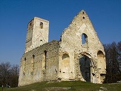
There is the Roman Catholic Church of St. Catherine of Alexandria from 1652 and the cemetery of All Saints Church of the 1172nd In the center of the chapel in 1743 dedicated to Our Lady of Mount Caramel. In the administrative area of the village are the ruins of the monastery and church of St. Catherine of Alexandria in 1618, and Mudrochov mill. [edit] Apparitions of Mary
In Dechtice since 1994 some visionary allegedly appeared repeatedly Mary.In the Archdiocese of Bratislava-Trnava was 28 October 1998 established the Commission for examination of the apparitions of the Virgin Mary in Dechtice, since ecclesiastical authority of revelation examined.
By Dechtice there are pilgrimages to the "mountain of revelation"
This is translate from "Google translate" sorry for mistakes.
External links
- http://www.dechtice.sk
- http://www.statistics.sk/mosmis/eng/run.html
- http://www.fara.sk/dechtice/
- http://www.avemaria.sk/dechtice/
- http://www.katarinka.sk/
- http://www.planinka.sk/
Trnava
Biely Kostol · Bíňovce · Bohdanovce nad Trnavou · Boleráz · Borová · Brestovany · Bučany · Buková · Cífer · Dechtice · Dlhá · Dobrá Voda · Dolná Krupá · Dolné Dubové · Dolné Lovčice · Dolné Orešany · Horná Krupá · Horné Dubové · Horné Orešany · Hrnčiarovce nad Parnou · Jaslovské Bohunice · Kátlovce · Košolná · Križovany nad Dudváhom · Lošonec · Majcichov · Malženice · Naháč · Opoj · Pavlice · Radošovce · Ružindol · Slovenská Nová Ves · Smolenice · Suchá nad Parnou · Šelpice · Špačince · Šúrovce · Trstín · Vlčkovce · Voderady · Zavar · Zeleneč · Zvončín Categories:
- Trnava Region geography stubs
- Villages and municipalities in Trnava District
Wikimedia Foundation. 2010.

