- Nowy Łupków
-
Nowy Łupków — Village — Village church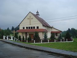

 Nowy Łupków
Coordinates: 49°15′24″N 22°5′2″E / 49.25667°N 22.08389°E Country  Poland
Voivodeship Subcarpathian County Sanok Gmina Komańcza Population 390 Nowy Łupków [ˈnɔvɨ ˈwupkuf] is a village in the administrative district of Gmina Komańcza, within Sanok County, Subcarpathian Voivodeship, in south-eastern Poland, close to the border with Slovakia.[1] It lies approximately 11 kilometres (7 mi) south of Komańcza, 34 km (21 mi) south of Sanok, and 87 km (54 mi) south of the regional capital Rzeszów. The village has a population of 390.
The village emerged when the local narrow gauge railway station was built in 1872, along the line from Zagórz to then-Hungarian-owned Slovakia. At first, its inhabitants were mostly working on the railways. Currently, it is the southernmost railroad station in Poland, and a rail border crossing with Slovakia.
A penal colony was built here after the Second World War, in which a number of Solidarność representatives were imprisoned during the Martial law in Poland period in 1981 and 1982.
References
Seat Other villages Balnica · Banniczka · Czystogarb · Darów · Dołżyca · Duszatyn · Jasiel · Jawornik · Kulaszne · Łupków · Maniów · Mików · Moszczaniec · Nowy Łupków · Osławica · Polany Surowiczne · Prełuki · Radoszyce · Rzepedź · Smolnik · Surowica · Szczawne · Turzańsk · Wisłok Wielki · Wola Michowa · Wysoczany · Zawadka MorochowskaCategories:- Villages in Sanok County
- Sanok County geography stubs


Wikimedia Foundation. 2010.