- Brandywine Creek (Cuyahoga River)
Infobox_River
river_name =Brandywine Creek (Cuyahoga River)
image_size =
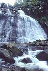
caption = Brandywine Falls of Brandywine Creek inSummit County, Ohio
origin = coord|41|17|33|N|81|27|48|W|region:US-OH_type:river_source:GNISGnis|1066599|Brandywine Creek]
mouth = coord|41|17|10|N|81|33|50|W|region:US-OH_type:river_source:GNIS|display=inline,titleCuyahoga River
basin_countries =United States of America
length =
elevation = Unit ft|1165|1 [cite web
title = Brandywine Creek (Cuyahoga River) from USGS-GNIS source
publisher =TerraServer-USA
url = http://terraserver-usa.com/map.aspx?t=2&s=11&lon=-81.463333&lat=41.2925&w=600&h=400&opt=0&f=Tahoma,Verdana,Arial&fs=8&fc=ffffff99
format = HTML]
mouth_elevation = Unit ft|636|1
discharge =
watershed =Brandywine Creek (Cuyahoga River) [United States Geological Survey Hydrological Unit Code: 04-11-00-02- Cuyahoga Watershed Fact|date=June 2008] is atributary of theCuyahoga River that is partly contained inCuyahoga Valley National Park inOhio .Watershed
The river runs into the
Cuyahoga River in Sagamore Hills Township near the now-abandoned Jaite Paper Mill. Discharge volume is extremely seasonal, usually a few cubic feet per second, and peaking at several hundred cubic feet per second under flood conditions. [cite web
title = Water - Instantaneous Data Archive (IDA) - 04206420 Brandywine Creek near Jaite OH
publisher =U.S. Geological Survey
url = http://ida.water.usgs.gov/ida/available_records.cfm?sn=04206420
format = html]The Brandywine Creek watershed begins in the northern portion of Hudson, and includes the cities of Hudson, Macedonia and Twinsburg, and the townships of Boston, Sagamore Hills, and Northfield Center.
Brandywine Falls
Brandywine Falls, convert|86|ft|m|1 high, at coord|41|16|37|N|81|32|17|W|region:US-OH_type:landmark_source:GNIS|display=inline, Elevation: convert|814|ft|m|1Gnis|1068315|Brandywine Falls] , within
Cuyahoga Valley National Park , is accessed by a parking lot located on Stanford Road, about convert|100|ft|m|1 from Brandywine Road, approximately convert|2|mi|km|1 South ofOhio State Route 82 , and convert|1|mi|km|1 North-West of Olde Eight inSagamore Hills, Ohio .Rock Layers
The rock layers of the 60-foot-tall Brandywine Falls can be read like a book. Each chapter covers millions of years, as ancient seas left behind sediments that were compressed by added layers. The rocks here at the base of the falls were formed more than 400 million years ago.
Brandywine Creek and the "bridalveil" cascades began about ten thousand years ago after the last glacial retreat. The falls have now exposed the harder, yellow-brown
Berea sandstone looming over the softer, deep red Bedford Shale. Since sandstone is more resistant to erosion, the shale below is frequently undercut. As these layers wear away, the story of the earth continues to be revealed.An exhibit near the falls includes a photo of the waterfalls, a map of the area, and a cross-sectional drawing of the rock with:
*Berea sandstone (320 million years),
*Bedford Shale (350 million years), and
*Cleveland Shale (350 - 400 million years)
labeled. [cite web
title = Brandywine Falls
publisher =National Park Service
url = http://www.nps.gov/archive/cuva/visitonline/brandywine/BWFalls.htm
format = HTML]Village of Brandywine
Brandywine Falls was the site of the now "abandoned" Village of Brandywine.
ee also
*
Brandywine (disambiguation)
*List of rivers of Ohio References
External links
*
National Park Service :*cite web
title = Cuyahoga Valley National Park
publisher =National Park Service
url = http://www.nps.gov/cuva/
format = HTML
Wikimedia Foundation. 2010.