- Mafadi
-
Mafadi Location of Mafadi in South Africa (on border with Lesotho)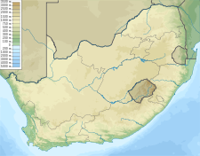
 Mafadi
Elevation 3,450 m (11,319 ft) Listing Country high point Location Location  South Africa and
  Lesotho
Range Drakensberg Coordinates 29°12′08.4″S 29°21′25.5″E / 29.202333°S 29.357083°ECoordinates: 29°12′08.4″S 29°21′25.5″E / 29.202333°S 29.357083°E Mafadi is a peak on the border of South Africa and Lesotho. At a height of 3,450 metres (11,320 ft), it is the highest mountain in South Africa, but is lower than Thabana Ntlenyana, the highest peak in Lesotho which is, at 3,482 metres (11,424 ft), the highest point in Southern Africa. Mafadi lies at S 29 12 08.4 E 29 21 25.5 in the WGS84 format.
Contents
Ascent
Ascents of Mafadi, attempted from the South African side, are normally made from the Injisuthi campsite. The route involves about an eight-kilometre hike to Marble Baths. This is followed by continuing up the river and with a combination of short paths and boulder hopping. This all ends at the bottom of the ridge, which leads to the Molar, with a campsite. The subsequent path up the ridge to the top of the mountains is known as Leslie's Pass. The path follows the ridge until below a rocky band where it traverses to southern side. The way continues up a short scree section, followed by more hiking up quite a steep gradient, until the final 20 metres are made up a grassy slope. From here, the top of Leslie's Pass (at S 29 09 12.7 E 29 20 38.0), the top of the mountains are followed to Mafadi.
A route referred to as the Corner-Leslies Loop is becoming a popular way of reaching Mafadi. It entails hiking to Centenary Hut in Injisuthi Nature Reserve on day 1, ascending Corner Pass and climbing Mafadi on day 2, descending Leslie's Pass on day 3 and reaching the car park on day 4.
29°12′S 29°21′E / 29.2°S 29.35°E
Disputed name
The dispute regarding the name of Mafadi (which literally means the Mother of Fadi) is currently under dispute, its original Sotho name is Ntheledi (which means "Makes me slip", referring to the nearby stream) is considered by some to be more relevant and correct.
External links
- Mafadi, South Africa/Lesotho
- Mafadi Peak Photograph
- Lynx Africa: Trails Lesotho South Africa
- Peak High mountaineering South Africa
References
Categories:- Drakensberg
- Mountains of South Africa
- Mountains of Lesotho
- International mountains of Africa
- Lesotho–South Africa border

Wikimedia Foundation. 2010.