Monticello Dam

Monticello Dam
Monticello Dam
Location Napa County, California, U.S.
Coordinates 38°30′48″N 122°06′15″W / 38.5133°N 122.1042°W / 38.5133; -122.1042Coordinates: 38°30′48″N 122°06′15″W / 38.5133°N 122.1042°W / 38.5133; -122.1042
Construction began 1953
Opening date 1957
Dam and spillways
Height 304 ft (93 m)
Length 1,023 ft (312 m)
Base width 100 ft (30 m)
Impounds Putah Creek
Reservoir
Creates Lake Berryessa
Capacity 1,602,000 acre·ft (1.976×10⁹ m3)
Catchment area 566 sq mi (1,470 km2)[1]
Surface area 20,700 acres (8,400 ha)
U.S. Geological Survey Geographic Names Information System: Monticello Dam

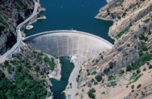
Monticello Dam is a dam in Napa County, California, United States constructed between 1953 and 1957. It is a medium concrete-arch dam with a structural height of 304 ft (93 m) and a crest length of 1,023 ft (312 m). It contains 326,000 cubic yards (249,000 m³) of concrete. The dam impounded Putah Creek to cover the former town of Monticello and flood Berryessa Valley to create Lake Berryessa, then the second-largest man-made lake in California. The capacity of the reservoir is 1,602,000 acre·ft (1.976×10⁹ m3).[1] Water from the reservoir primarily supplies agriculture in surrounding areas. The dam is noted for its classic, uncontrolled morning-glory type spillway.[1] The diameter at the lip is 72 ft (22 m). Locally, the spillway is also known as 'The Glory Hole'. [2]

The Monticello Dam Powerplant was built at the dam in 1983 and has three generators. The electrical power is sent mostly to the North Bay area of San Francisco.

References

External links


Wikimedia Foundation. 2010.

Игры ⚽ Поможем написать курсовую

Look at other dictionaries:

  • Monticello, California — Monticello   Former settlement   …   Wikipedia

  • Monticello (disambiguation) — Monticello is the name of Thomas Jefferson s estate near Charlottesville, Virginia in the United States. The name may also refer to: Contents 1 Places 1.1 France 1.2 Italy 1.3 United States …   Wikipedia

  • Monticello Reservoir — The Monticello Reservoir with a view of the Virgil C. Summer Nuclear Generating Station Location Fairfield County, South Carolina, USA Co …   Wikipedia

  • Barrage Monticello — Le barrage vu de l aval Le barrage Monticello est un barrage dans le comté de Napa en Californie, aux États Unis (situé à …   Wikipédia en Français

  • Delhi Dam — Delhi Dam …   Wikipedia

  • Lake Monticello, Virginia — Infobox Settlement official name = Lake Monticello, Virginia settlement type = CDP nickname = motto = imagesize = image caption = image mapsize = 250px map caption = Location of Lake Monticello, Virginia mapsize1 = map caption1 = subdivision type …   Wikipedia

  • Rancho Las Putas — was a 35,516 acre (143.73 km2) Mexican land grant in present day Napa County, California given in 1843 by Governor Manuel Micheltorena to José de Jesús Berreyesa and Sexto Sisto Berreyesa. The name Las Putas came from Putah Creek, which ran… …   Wikipedia

  • Putah Creek — Geobox|River name = Putah Creek native name = Liwaito other name = category = stream etymology = nickname = image caption = Putah Creek, UC Davis Arboretum country = United States state = California region = Yolo, Solano, Napa, and Lake counties… …   Wikipedia

  • Lake Berryessa — Infobox lake lake name = Lake Berryessa image lake = Wfm lake berryessa landsat.jpg caption lake = Satellite photo image bathymetry = caption bathymetry = location = Napa County, California coords = coord|38.570938|N|122.23526|W|region:US CA type …   Wikipedia

  • Dorothea Lange — in 1936 Born May 26, 1895(1895 05 26) Hoboken, New Jersey Died …   Wikipedia

Share the article and excerpts

Direct link
Do a right-click on the link above
and select “Copy Link”