- Chamartín
-
For the railway station, see Madrid Chamartín railway station.
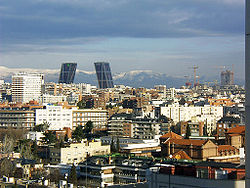
Chamartín — District of Madrid — Gate of Europe towers and the Cuatro Torres Business Area under construction Country  Spain
SpainAut. community  Madrid
Municipality  Madrid
Government - Concejal Madrid district number 5 Address of council Chamartín is an administrative district of Madrid, Spain and consists of the following neighborhoods: El Viso, Prosperidad, Ciudad Jardín, Hispanoamérica, Nueva España, and Pza. Castilla. It was originally named Chamartin de la Rosa and remained a feudal estate until it was incorporated to Madrid in 1948 [1]
Contents
Overview
It is bounded by the Paseo de la Castellana to the west, the Autopista de Circunvalación M-30 to the north and east, and the Autovía A-2 to the south.
Some of the landmarks of Chamartin are the Gate of Europe, a pair of inclined office buildings; the Santiago Bernabéu Stadium, home of the football team Real Madrid; Chamartín Station, the second largest train station in Madrid; the Cuatro Torres Business Area, a business park that comprises the four tallest skyscrapers in Spain; and the National Auditorium of Music (the main concert hall in Madrid) which hosts the Spanish National Orchestra.
Geography
Subdivision
The district is administratively divided into 6 wards (Barrios):
- Castilla
- Ciudad Jardín
- El Viso
- Hispanoamérica
- Nueva España
- Prosperidad
Economy
The district has the head office of Iberia Airlines.[2]
Photogallery
References
- ^ Gea, Isabel. Historia de los distritos de Madrid: Chamartín. Ediciones La Libreria, 2001
- ^ "Legal notice." Iberia. Retrieved on 25 February 2010. "IBERIA, Líneas Aéreas de España, S.A. with official address at Calle Velázquez no. 130, 28006 Madrid,"
External links
 Media related to Chamartín at Wikimedia Commons
Districts and wards of Madrid Arganzuela Atocha • Imperial • La Chopera • Las Acacias • Las Delicias • Legazpi • Palos de Moguer

Barajas Aeropuerto • Alameda de Osuna • Casco Histórico de Barajas • Corralejos • TimónCarabanchel Abrantes • Buenavista • Comillas • Opañel • Puerta Bonita • San Isidro • Vista AlegreCentro Cortes • Embajadores • Justicia • Malasaña • Palacio • SolChamartín Castilla • Ciudad Jardín • El Viso • Hispanoamérica • Nueva España • ProsperidadChamberí Almagro • Arapiles • Joaquín Gaztambide • Ríos Rosas • Trafalgar • VallehermosoCiudad Lineal Atalaya • Colina • Concepción • Pinar de Chamartín • Pueblo Nuevo • Quintana • San Juan Bautista • San Pascual • VentasFuencarral-El Pardo Barrio del Pilar • El Goloso • El Pardo • Fuentelarreina • La Paz • Mirasierra • Peñagrande • ValverdeHortaleza Apóstol Santiago • Canillas • Palomas • Pinar del Rey • Piovera • ValdefuentesLatina Aluche • Campamento • Cuatro Vientos • Las Águilas • Lucero • Los Cármenes • Puerta del ÁngelMoncloa-Aravaca Aravaca • Argüelles • Casa de Campo • Ciudad Universitaria • El Plantío • Valdemarín • ValdezarzaMoratalaz Fontarrón • Horcajo • Marroquina • Media Legua • Pavones • VinaterosPuente de Vallecas Entrevías • Numancia • Palomeras Bajas • Palomeras Sureste • Portazgo • San DiegoRetiro Adelfas • Estrella • Ibiza • Jerónimos • Niño Jesús • PacíficoSalamanca Castellana • Fuente del Berro • Goya • Guindalera • Lista • Parque de las Avenidas • RecoletosSan Blas Amposta • Arcos • Canillejas • Hellín • Rejas • Rosas • Salvador • SimancasTetuán Almenara • Bellas Vistas • Berruguete • Castillejos • Cuatro Caminos • ValdeacederasUsera Almendrales • Moscardó • Orcasitas • Orcasur • Pradolongo • San Fermín • ZofíoVicálvaro Ambroz • Casco Histórico de VicálvaroVilla de Vallecas Casco Histórico de Vallecas • Santa Eugenia
Coordinates: 40°42′06″N 4°57′26″W / 40.7017°N 4.95722°WCategories:- Districts of Madrid
- Madrid geography stubs
Wikimedia Foundation. 2010.


