Cowton railway station

Cowton railway station
Cowton
Cowton station.jpg
Cowton Station
Location
Place East Cowton
Area Hambleton
Coordinates 54°25′43″N 1°30′37″W / 54.428545°N 1.510340°W / 54.428545; -1.510340Coordinates: 54°25′43″N 1°30′37″W / 54.428545°N 1.510340°W / 54.428545; -1.510340
Grid reference NZ318037
Operations
History
Disused railway stations in the United Kingdom
Closed railway stations in Britain
A B C D–F G H–J K–L M–O P–R S T–V W–Z
Portal icon UK Railways portal

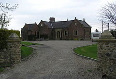
Cowton railway station is a disused station on the East Coast Main Line, it is situated in the Hambleton district of North Yorkshire in England the station is situated around 0.5 miles (0.8 km) east of the village of East Cowton.

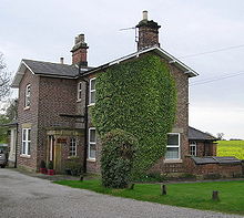
Several of the railway buildings have survived the closure of the station and are now used as residential properties.

Station masters House

See also

External links

Preceding station Disused railways Following station
Eryholme
Station closed
  East Coast Main Line
Former local services
  Danby Wiske
Station closed


Wikimedia Foundation. 2010.

Игры ⚽ Нужна курсовая?

Look at other dictionaries:

  • Eryholme railway station — Eryholme Location Area Richmondshire Coordinates …   Wikipedia

  • Moulton (North Yorkshire) railway station — Moulton Moulton station house Location Place North Cowton …   Wikipedia

  • Moulton End railway station — was a railway station in what is now the Richmondshire district of North Yorkshire, England. It was situated near the village of North Cowton. Moulton End was the Eryholme Richmond branch line which was opened in 1846 by the York and Newcastle… …   Wikipedia

  • Cowton — may refer to: People Gary Cowton (born 1952), a former Australian rules footballer Robert Cowton, a Franciscan theologian active at the University of Oxford in the fourteenth century Places Three villages and civil parishes in the district of… …   Wikipedia

  • East Cowton — infobox UK place country = England latitude= 54.4245 longitude= 1.5260 official name= East Cowton population = 650 shire district= Hambleton region= Yorkshire and the Humber shire county = North Yorkshire constituency westminster= Richmond post… …   Wikipedia

  • North Cowton — Coordinates: 54°25′45″N 1°33′35″W / 54.4291°N 1.5598°W / 54.4291; 1.5598 …   Wikipedia

  • Birkby, North Yorkshire — infobox UK place country = England official name= Birkby latitude= 54.4153 longitude= 1.4875 population = 40 shire district= Hambleton region= Yorkshire and the Humber shire county = North Yorkshire constituency westminster= Richmond post town=… …   Wikipedia

  • Northallerton — Coordinates: 54°20′16″N 1°25′43″W / 54.3378°N 1.4285°W / 54.3378; 1.4285 …   Wikipedia

  • Manchester Arndale — Location Manchester, England Coordinates …   Wikipedia

  • Moulton End — Coordinates: 54°25′48″N 1°34′45″W / 54.429936°N 1.579166°W / 54.429936; 1.579166 …   Wikipedia

Share the article and excerpts

Direct link
Do a right-click on the link above
and select “Copy Link”