- Agus River
Geobox River
name = Agus River
native_name =
other_name =
other_name1 =
image_size =
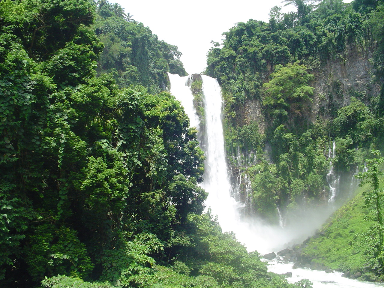
image_caption =Maria Cristina Falls , one of the prominent geographical landmark on the Agus River, is a host to the NAPOCOR'shydroelectric project that generates 70% ofMindanao 's electricity
country = flagicon|PhilippinesPhilippines
region =Northern Mindanao
region1 =ARMM
district =
district1 =
city =Iligan City
city1 =
length = 36.5
length_round = 2
watershed = 1645
watershed_round = 2
discharge_location =Iligan Bay
discharge = 10
discharge_round = 2
discharge_max =
discharge_max_round =
discharge_min =
source_name =Lake Lanao
source_location =Lanao del Sur
source_district =
source_region =ARMM
source_lat_d = 7
source_lat_m = 53
source_lat_s = 31
source_lat_NS = N
source_long_d = 124
source_long_m = 15
source_long_s = 09
source_long_EW = E
source_elevation = 700
source_length =
mouth_name =
mouth_location =Iligan Bay
mouth_region =Northern Mindanao
mouth_lat_d = 8
mouth_lat_m = 25
mouth_lat_s =
mouth_lat_NS = N
mouth_long_d = 124
mouth_long_m = 05
mouth_long_s =
mouth_long_EW = E
mouth_elevation = 0
tributary_left =
tributary_left1 =
tributary_right =
tributary_right1 =
free_name =
free_value =
map_size = 300
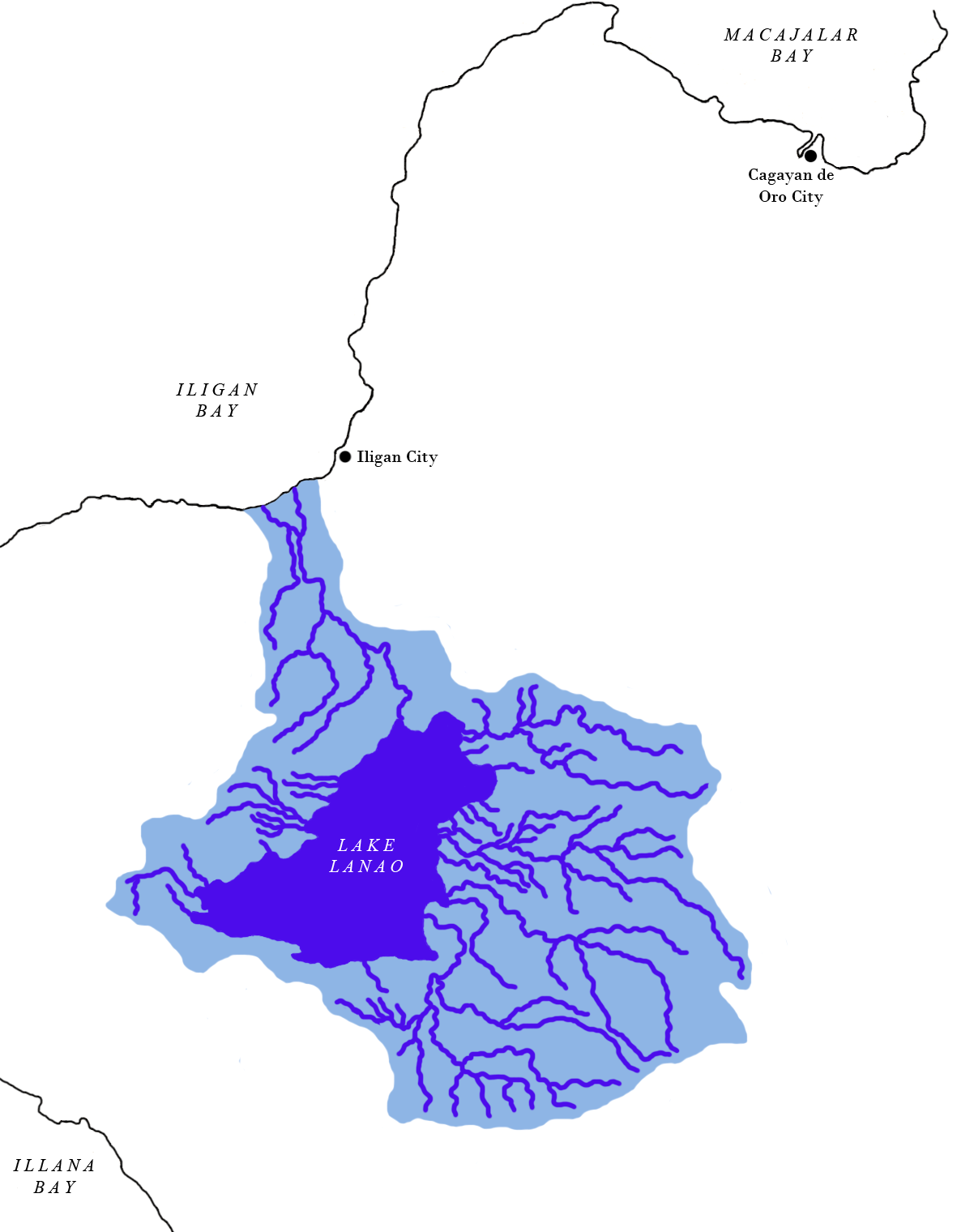
map_caption = Lake Lanao-Agus River watershed areaAgus River is a river that flows for 36.5 km [cite web |url=http://www.iligan.gov.ph/index.php?option=com_content&task=view&id=423&Itemid=359 |title=Official Website of the Iligan City Government - Growth of an Industrial City |accessdate=2008-03-29 |accessmonthday= |accessyear= |author=Prof. Geoffrey G. Salgado |date=| work= |publisher=Iligan City Government ] ["Principal River Basins of the Philippines", Published by the National Water Resources Board, October 1976 (p. 12)] from
Lanao Lake toIligan Bay ,Philippines . It cuts through the provinces ofLanao del Sur andLanao del Norte . Settlements along the banks of the river include the City of Marawi, the Municipality of Linamon and the City of Iligan. It separates into two channels as it drains to Iligan Bay; one going over theMaria Cristina Falls while the other supplies the Linamon Falls. cite web |url=http://www.iwmi.cgiar.org/wetlands/pdf/Philippines.pdf |title=Philippines |accessdate=2008-03-29 |last=The the Haribon Foundation for the Conservation of Natural Resources |first= |coauthors= |date= |work= |publisher=International Water Management Institute |pages=69-70] The river descends for about 2,200 feet from its source as it flows for 21 miles before draining to the sea. The river is relatively shallow as it is only 4 feet deep in some areas. [cite book |title=United States Coast Pilot, Philippine Islands... |last=U.S. Coast and Geodetic Survey |first= |authorlink= |coauthors= |year=1921 |publisher=Govt. print. off. |location= |isbn= |pages=134 ] The Agus River's watershed spans about 11,320.00 hectares. [cite web |url=http://r10.denr.gov.ph/watershedslanaodelnorte.html |title=Watershed Areas |accessdate=2008-03-29 |last= |first= |coauthors= |date=2006 |work= |publisher=Department of Environment and Natural Resources (Philippines)] In 1992, the National Power Corporation financed the reforestation of the Lake Lanao-Agus River watershed, planting over 1500 hectares of "Acacia mangium ", "Durio zibethinus " and other indigenous trees. [cite journal |last=Mero |first=D.C. |authorlink= |coauthors= |year= |month= |title= Financing community-based watershed reforestation in the Philippines. |journal= |volume= |issue= |pages= |id= |url= FAO Regional Office for Asia and the Pacific |accessdate= 2008-03-29 |quote= ] It has a discharge of about 10 second-meters and flows from a narrow depression off the northwestern rim of the lake [cite journal |last=Pendleton |first=Robert L. |authorlink= |coauthors= |year=1942 |month=April |title=Land Utilization and Agriculture of Mindanao, Philippine Islands |journal=Geographical Review |volume=32 |issue=2 |pages=180–210 |id= |url=http://links.jstor.org/sici?sici=0016-7428(194204)32%3A2%3C180%3ALUAAOM%3E2.0.CO%3B2-C |accessdate= 2008-03-29 |quote= |doi=10.2307/210270 ] and flows over a basalt rock formation. [cite book |title= Monograph |last=Philippines Bureau of Science |first= |authorlink= |coauthors= |year= |publisher= |location= |isbn= |pages=207 ] The canyon carved by the river suggests a short erosional period. [cite book |title=Papers on Evolution |last=Ehrlich |first=Paul R. |authorlink= |coauthors= Richard W. Holm, Peter H. Raven |year=1969 |publisher=Little, Brown |location= |isbn= |pages= ]Importance to humans
The lake and the river are used for both commercial and sport fishing, as well as for recreational activities such as boating and swimming. The river in its entirety, however, is not navigable due to the fact that the current in some areas reaches a velocity of up to thirty miles an hour. [cite book |title=The Philippine review (Revista filipina): (Revista Filipino); a Monthly ... |last=Nieva |first=Gregorio |authorlink= |coauthors= |year=1921 |publisher=Gregorio Nieva |location= |isbn= |pages=102] Together with Lanao Lake, the Agus River generates 70% of the electricity used in Mindanao due to the hydroelectric plants in the river and Maria Cristina Falls. However, the hydroelectric plants and the requisite regulatory dams have changed the fluctuations of the water level of Lake Lanao, affecting the indigenous people, producing conflicts with the local population. [cite web |url=http://www.international-alert.org/pdfs/econonics_and_conflict_in_mindanao.pdf |title=Breaking the links between economics and conflict in Mindanao |accessdate=2008-03-29 |last=Concepciòn |first=Sylvia |coauthors=Larry Digal, Rufa Guiam, Romulo de la Rosa, Mara Stankovitch |date=
December 2003 |work= |publisher=International Alert]In
Maranao mythology, Lake Lanao once threatened to drown the people of Sebangan with its ever-rising waters. TheArchangel Gabriel is thought to have made the Agus river in order to drain the lake. [cite web |url=http://www.seasite.niu.edu/Tagalog/folktales/Maranao/how_the_angels_built_lake_lanao.htm |title=How the Angels Built Lake Lanao |accessdate=2008-03-29 |author= |date= |work= |publisher=SEAsite: Center for Southeast Asian Studies Northern Illinois University]References
Wikimedia Foundation. 2010.