North Fork Grand River (South Dakota)
- North Fork Grand River (South Dakota)
-
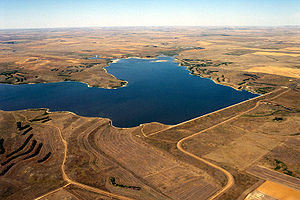
Bowman-
Haley Dam and Lake on the North Fork of the Grand River in Bowman County,
North Dakota
The North Fork of the Grand River is a tributary of the Grand River, approximately 80 mi (129 km) long, in North Dakota and South Dakota in the United States.
It rises in the Badlands of southwestern North Dakota, in southern Bowman County, and flows ESE, through the Bowman Haley Lake, formed by the Bowman Haley Dam, then into northwestern South Dakota, past several units of the Grand River National Grassland in northern Perkins County. It joins the South Fork near Shadehill to form the Grand.
See also
- List of North Dakota rivers
- List of South Dakota rivers
Categories: - Rivers of North Dakota
- Rivers of South Dakota
- North Dakota geography stubs
- South Dakota geography stubs
Wikimedia Foundation.
2010.
Look at other dictionaries:
South Fork Grand River (South Dakota) — The South Fork of the Grand River is a tributary of the Grand River, approximately 90 mi (145 km) long, in South Dakota in the United States.It rises in the Badlands of northwestern South Dakota, south of the Cave Hills in western Harding County … Wikipedia
Grand River (South Dakota) — Gewässerkennzahl US: 1265233 Lage South Dakota (USA) Flusssystem … Deutsch Wikipedia
Grand River (South Dakota) — The Grand River is a tributary of the Missouri River in North Dakota and South Dakota in the United States. The length of the combined branch is 110 mi (177 km). With its longest fork, its length is approximately 200 mi (320 km).It is formed by… … Wikipedia
North Fork Republican River — North Fork Republican River[1] Origin 39°59′58″N 102°27′14″W … Wikipedia
Grand River — Caractéristiques Longueur 320 km Bassin 13 900 km2 Bassin collecteur … Wikipédia en Français
Liste der Flüsse in South Dakota — Die Liste der Flüsse in South Dakota nennt alle Flüsse im US Bundesstaat South Dakota in alphabetischer Reihenfolge und nach Einzugsgebieten geordnet. Inhaltsverzeichnis 1 Alphabetische Reihenfolge 2 Nach Einzugsgebieten 2.1 Einzugsgebiet des… … Deutsch Wikipedia
List of rivers of South Dakota — This is a list of rivers in the state of South Dakota in the United States.Alphabetically*Bad River *Big Sioux River *Belle Fourche River *Bois de Sioux River *Castle Creek *Cherry Creek *Cheyenne River *Elm River *French Creek *Grand River… … Wikipedia
National Register of Historic Places listings in Harding County, South Dakota — Location of Harding County in South Dakota This is a list of the National Register of Historic Places listings in Harding County, South Dakota. This is intended to be a complete list of the properties on the National Register of Historic Places… … Wikipedia
Liste des cours d'eau du Dakota du Sud — Le Dakota du Sud est traversé par le Missouri, un affluent du Mississippi, et par de nombreux autres cours d eau. Liste alphabétique Bad River Belle Fourche Big Sioux Bois de Sioux Castle Creek Cherry Creek Cheyenne Elm River French Creek Grand… … Wikipédia en Français
Liste der Flüsse in North Dakota — Dies ist eine Liste der Flüsse in North Dakota in den Vereinigten Staaten. Inhaltsverzeichnis 1 Alphabetisch 2 Nach Vorfluter 2.1 Missouri River 2.2 Red River of the North … Deutsch Wikipedia

