Dom Noi River

Dom Noi River
The Dom Noi River that stopped by Sirindhorn Dam

The Dom Noi River (Thai: ลำโดมน้อย, RTGS: Lam Dom Noi, Thai pronunciation: [lam doːm nɔ́ːj]) is a tributary of the Mun River, originates in the Dongrek mountains and flows northwards. The river passes Buntharik district and is stopped by the Sirindhorn Dam in Tambon Chong Mek, Sirindhorn district. It is 150 km long.
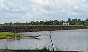
Srindhorn Reservoir

The Sirindhorn reservoir is the biggest water resource of Ubon Ratchathani Province.


Wikimedia Foundation. 2010.

Игры ⚽ Нужно сделать НИР?

Look at other dictionaries:

  • River Systems of Thailand — The two principal river systems of Thailand are the Chao Phraya and the Mekong. Together, these rivers support the irrigation for Thailand s agricultural economy. In addition to these two large systems, there are a number of other river systems… …   Wikipedia

  • Mun River — Coordinates: 15°19′14″N 105°30′29″E / 15.32056°N 105.50806°E / 15.32056; 105.50806 …   Wikipedia

  • Mekong River Basin Hydropower — Existing, under construction and planned hydropower dams in the Mekong River Basin. The estimated hydropower potential of the lower Mekong Basin (i.e. excluding China) is 30,000 MW,[1] while that of the upper Mekong Basin is 28,930 MW …   Wikipedia

  • List of Thailand-related articles — Thailand, known officially as the Kingdom of Thailand (IPAEng|ˈtaɪlænd, th. ราชอาณาจักรไทย, IPA2|râːtɕʰa ʔaːnaːtɕɑ #x0300;k tʰɑj) is a country in Southeast Asia. To its east lie Laos and Cambodia; to its south, the Gulf of Thailand and Malaysia;… …   Wikipedia

  • Amphoe Sirindhorn — Infobox Amphoe thai=สิรินธร name=Sirindhorn province=Ubon Ratchathani coordinates=coord|15|12|6|N|105|23|54|E|type:adm2nd region:TH capital=Nikhom Sang Ton eng Lam Dom Noi area=370.0 population=48,156 population as of=2005 density=130.2 postal… …   Wikipedia

  • Amphoe Buntharik — Infobox Amphoe name=Buntharik thai=บุณฑริก province=Ubon Ratchathani coordinates=coord|14|45|24|N|105|24|41|E|type:adm2nd region:TH capital=Phon Ngam area=1,402.0 population=88,052 population as of=2005 density=62.8 postal code=34230… …   Wikipedia

  • O Chum 2 Hydropower Dam — Official name O Chum 2 Hydropower Dam Location Banlung, Ratanak Kiri Province, Cambodia Opening date 1992[1] Owner(s) Cambodia Government …   Wikipedia

  • Don Moi — La Don Moi sous le barrage Sirindorn Bassin versant de la Mun : Le lac du barrage Sirindhorn est visible en bas à droite …   Wikipédia en Français

  • Ubon Ratchathani Province — Infobox Thai Province name = Ubon Ratchathani thai = อุบลราชธานี capital = Ubon Ratchathani area = 15,744.8 arearank = 5th population = 1,691,441 population as of = 2000 populationrank = 4th density = 107 densityrank = 44th isocode = TH 34… …   Wikipedia

  • Sistemas fluviales de Tailandia — Mapa topográfico de Tailandia que muestra todo el sistema del río Chao Phraya, en las llanuras centrales, y las ramales del sistema del río Mekong, que fluyen de oeste a este. Los dos principales sistemas fluviales de Tailandia son los del río… …   Wikipedia Español

Share the article and excerpts

Direct link
Do a right-click on the link above
and select “Copy Link”