- Saint John River
Infobox River | river_name = Saint John River
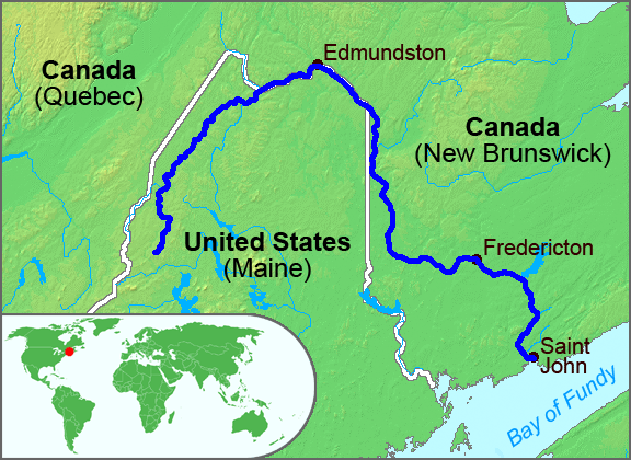
caption = The course of the St. John River
origin = NorthwesternMaine
mouth =Bay of Fundy at Saint John, NB
basin_countries =Canada ,United States
length = 673 km (418 mi)
elevation = 360 m (1,181 ft)
discharge = 990 m³/s (35,000 ft³/s)
watershed = 54,986 km² (21,230 mi²)The Saint John River (French "Fleuve Saint-Jean") is a river, approximately 418 mi (673 km) long, located in theCanadian province ofNew Brunswick and theU.S. state ofMaine . It forms part of theCanada-US border in two places along its length. The river drains an area of approximately 55,000 km², of which slightly more than half is located in New Brunswick. The Saint John is also the second longest river on North America's Atlantic coastline (between theSt. Lawrence River and theMississippi River ). Only the Susquehanna is longer. The lower section of the river from Fredericton to Saint John is nicknamed the "Rhine of North America" in reference to its popularity for recreational boating [http://www.google.ca/search?hl=en&client=firefox-a&rls=org.mozilla%3Aen-US%3Aofficial&hs=f9V&q=%22Rhine+of+North+America%22+Saint+John+River&btnG=Search&meta=] .Description
The Saint John rises in Somerset County in northwestern Maine and flows northeast through western Aroostook County for a distance. Near Allagash, it is joined by the
Allagash River . The portion of the Saint John River that lies entirely inMaine is essentially a wilderness waterway. Below St. Francis, the Saint John begins to form part of theInternational Boundary between Maine and New Brunswick.Continuing its northeast course, the river passes
Fort Kent, Maine , and then flows betweenEdmundston, New Brunswick , andMadawaska, Maine , where it turns southeast, then passes betweenVan Buren, Maine , andSt. Leonard, New Brunswick . NearGrand Falls, New Brunswick , the river enters entirely into New Brunswick, and changes direction to flow due south through the fertileUpper St. John River Valley , framed by the rising hills of the Appalachian range in Victoria and Carleton counties. At Perth-Andover, the river is joined by the Aroostook and the Tobique rivers. At Hartland, it is crossed by the longest covered bridge in the world.. South of Fredericton the river becomes broad and shallow and it meanders through many low islands used for pastureland during dry periods in summer and fall.
South of the Jemseg, the Saint John River is surrounded by the low hills of the St. Croix Highlands - another component of the Appalachian range and it is joined by several lateral bays, including
Belleisle Bay ; then theNerepis River and theKennebecasis River . The St. John discharges into theBay of Fundy at the industrial city of Saint John. At the river's mouth, there is a unique phenomenon caused by the high tides of the Bay. These tides are the highest in the world and cause the river to reverse its flow twice a day in a narrow gorge in the city's centre, creating theReversing Falls Rapids .History
Members of the
Maliseet Nation, whose lands and culture have been and are still centered on the Saint John River have historically called the river "Wolastoq", translating to "good and beautiful river". In 1604, parts of the lower river were explored bySamuel de Champlain andSieur de Monts . Champlain named the river afterJohn the Baptist because he reached the river's mouth on the saint's feast day,June 24 .The river valley formed an important part of the French colony of
Acadia .Acadian settlements developed along the lower river during the 17th and 18th centuries; including Fort la Tour (Saint John) and Fort Sainte-Anne (Fredericton ). The area fell under English control during theSeven Years' War , after the English capture of Fort Sainte-Anne in 1759. In 1784, many loyalist refugees from theAmerican Revolutionary War settled in Saint John, Fredericton, and along the river at settlements such as Queensbury and Woodstock. The new English colony ofNew Brunswick was created shortly afterwards and Fredericton was named the capital. In 1785, Acadians created the first colony in the Upper Saint-John River valley, near what is now Edmundston. English settlement of the fertile Upper River Valley would not occur until the early to mid 19th century. A Danish community (New Denmark) was established in the late 1800s. Meanwhile, francophoneQuebec ers settled theMadawaska region, also during the 19th century, travelling southwards along traditionalportage routes. They joined the Acadians who were already settled in the area. The Madawaska section of the river valley remains heavily francophone to this day.The river was an important trade route for the French, English and
First Nations traders throughout the 17th and 18th centuries. The tremendous flow rate of the river and its tributaries during the springfreshet aided the development of the timber industry in western New Brunswick as the river became a conduit for log drives to saw and pulp mills in the south.can cause extensive flooding during the spring break-up.
The Saint John River has been of tremendous importance to the development of western New Brunswick because it served as a transportation artery, particularly prior to the era of
rail transport when paddle wheelers plied its waterways.During the 1950s and 1960s, the river became a major source of
hydroelectric power with the opening of theBeechwood Dam in 1955 and theMactaquac Dam in 1968 where large reservoirs have been created by damming its flow. These massive projects followed the construction of a smaller dam at Grand Falls in 1925, where the river descends in a steep cataract. A consequence of the latter two dams has been a severe decline in migratingAtlantic Salmon , and the flooding of farmland to create the headponds.In recent years, the river has seen a rise in recreational boating and
ecotourism . The rich soil of the Upper St. John River Valley in Carleton and Victoria counties as well asAroostook County, Maine , is also an important area for the cultivation ofpotatoes .Water flow
: "See also
2008 Saint John River Flood " at (coord|47|15|35|N|68|35|45|W|) where the rivershed is 5,665 square miles.WSC also maintains its own gauges on the river in New Brunswick at Edmundston, Grand Falls, Fredericton, Maugerville, Upper Gagetown, Gagetown, Oak Point, and Saint John.
At the most upstream gauge the riverflow has ranged from 44,400
cubic feet per second to 59 cubic feet per second. At the Dickey gauge flow has ranged from 91,700 cubic feet per second to 129 cubic feet per second. At the Clair gauge flow has ranged from 151,000 cubic feet per second to 510 cubic feet per second. Water flow is highest during the springfreshet and lowest in the fall. In early spring, upper sections of the river can experience ice jams causing flooding, [cite web | author=G.J. Stewart, J.P. Nielsen, J.M. Caldwell, A.R. Cloutier | year=2002| title=Water Resources Data - Maine, Water Year 2001 | format=PDF | work=Water Resources Data - Maine, Water Year 2001 | url=http://me.water.usgs.gov/Maine01adr.pdf | accessdate=2006-05-07] while in the lower sections in the broader floodplain, flooding may occur during late spring from the sheer volume of water which must make its way through the narrow gorge at theReversing Falls .ee also
*
List of crossings of the Saint John River
*List of Maine rivers
*List of New Brunswick rivers External links
*Voici the Valley Audio Story and Guide [http://www.voicithevalley.org information] and [http://mainehumanities.org/podcasts/index.html#valley excerpts]
* [http://www.mainerivers.org/st_john.html St. John River watershed map and information]
* [http://www.ccge.org/ccge/english/Resources/rivers/tr_rivers_stJohnRiver.asp Canadian Council for Geographic Education page with a series of articles on the history of the St. John River]
* [http://www.stjohnrivervalley.com A book covering the St. John River with full color photos]
* [http://www.omg.unb.ca/GGE/Sill_Survey.html Oceanographic study of the salt and fresh water exchange in the lower St. John River]
*Real-time river flow at [http://waterdata.usgs.gov/usa/nwis/uv?site_no=01010000 the upstream most gage] , [http://waterdata.usgs.gov/usa/nwis/uv?site_no=01010500 Dickey, Maine] , or [http://waterdata.usgs.gov/usa/nwis/uv?site_no=01014000 St. Clair, New Brunswick] .
* [http://www.upperstjohn.com/ The Upper St. John River Valley] history and genealogy.
*National Weather Service forecast of [http://newweb.erh.noaa.gov/ahps2/index.php?wfo=car river levels and flow]
*Live [http://newweb.erh.noaa.gov/images/ahps2/car/dicm1/netcam.jpgWebCam] coutesy of the Maine Department of Transportation.References
Wikimedia Foundation. 2010.