- Hartland, New Brunswick
Infobox Settlement
official_name = Hartland
other_name =
native_name =
nickname = Home of the World's Longest Covered Bridge
settlement_type =Town
motto =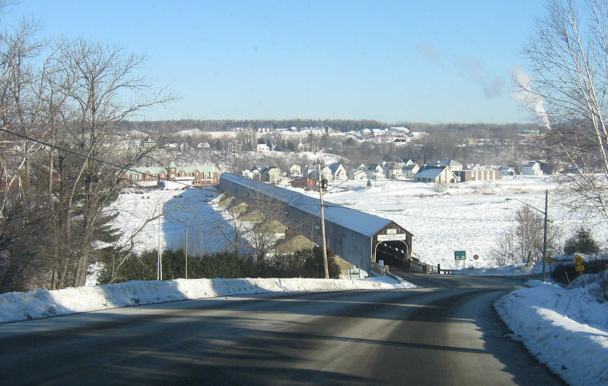
imagesize = 250px
image_caption =Hartland Bridge , with Hartland in the background
flag_size =
image_
seal_size =
image_shield =
shield_size =
city_logo =
citylogo_size =
mapsize =
map_caption =
mapsize1 =
map_caption1 =
image_dot_
dot_mapsize =
dot_map_caption =
dot_x = |dot_y =
pushpin_
pushpin_label_position =
pushpin_map_caption =
pushpin_mapsize =
subdivision_type = Country
subdivision_name =Canada
subdivision_type1 =Provinces of Canada
subdivision_name1 =New Brunswick
subdivision_type2 = County
subdivision_name2 = Carleton County
subdivision_type3 =
subdivision_name3 =
subdivision_type4 =
subdivision_name4 =
government_footnotes =
government_type =Town Council
leader_title =Mayor
leader_name = Neville Hargrove
leader_title1 =
leader_name1 =
leader_title2 =
leader_name2 =
leader_title3 =
leader_name3 =
leader_title4 =
leader_name4 =
established_title =Founded
established_date = 1813
established_title2 = Incorporated
established_date2 =October 2 ,1918
established_title3 =
established_date3 =
area_magnitude =
unit_pref =
area_footnotes =
area_total_km2 = 9.63
area_land_km2 =
area_water_km2 =
area_total_sq_mi =
area_land_sq_mi =
area_water_sq_mi =
area_water_percent =
area_urban_km2 =
area_urban_sq_mi =
area_metro_km2 =
area_metro_sq_mi =
area_blank1_title =
area_blank1_km2 =
area_blank1_sq_mi =
population_as_of = 2006
population_footnotes =
From StatsCan
population_note =
population_total = 947
population_density_km2 = 98.4
population_density_sq_mi =
population_metro =
population_density_metro_km2 =
population_density_metro_sq_mi =
population_urban =
population_density_urban_km2 =
population_density_urban_sq_mi =
population_blank1_title =
population_blank1 =
population_density_blank1_km2 =
population_density_blank1_sq_mi =
timezone = AST
utc_offset = -4
timezone_DST = ADT
utc_offset_DST = -3
latd= 46.29742
longd=-67.52742
elevation_footnotes =
elevation_m = 41 to 103
elevation_ft = 134 to 338
postal_code_type =Canadian Postal code
postal_code = E7P
area_code = 506
blank_name = Telephone Exchange
blank_info = 375
blank2_name = NTS Map
blank2_info = 021J05
blank3_name = GNBC Code
blank3_info = DAJRT =
website = http://www.town.hartland.nb.ca
footnotes =Hartland (2001 pop.: 902) is a town in Carleton County,
New Brunswick ,Canada .Hartland is situated on the
Saint John River in the central-western portion of the province in the agricultural heartland of Carleton County. It is the hometown of two of New Brunswick's premiers during the 20th century:Hugh John Flemming andRichard Hatfield . U.S.Congressmen Isaac & Samuel Stephenson andPrince Edward Island 'sLieutenant-Governor Barbara Oliver Hagerman are also from Hartland.The town is best known for being the site of the
Hartland Bridge , the longestcovered bridge in the world. Originally opened onJuly 4 ,1901 , the 1,282 foot (390.75 m) bridge is a national historic site. The bridge was covered as part of major repairs in 1921, and the pedestrian walkway added in 1945.Hartland is the headquarters of the North American trucking company Day & Ross, as well as home to the
New Brunswick Bible Institute .External links
* [http://bridges.nblighthouses.com/ New Brunswick Covered Bridges]
* [http://www.town.hartland.nb.ca/ Town of Hartland Website]

Wikimedia Foundation. 2010.