- Classon Avenue (IND Crosstown Line)
-
Classon Avenue

New York City Subway rapid transit station 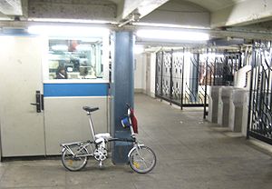
Station statistics Address Classon Avenue & Lafayette Avenue
Brooklyn, NY 11205Borough Brooklyn Locale Bedford Stuyvesant, Clinton Hill Coordinates 40°41′20″N 73°57′36″W / 40.688839°N 73.960047°WCoordinates: 40°41′20″N 73°57′36″W / 40.688839°N 73.960047°W Division B (IND) Line IND Crosstown Line Services G  (all times)
Connection - New York City Bus: B38 B38LTD, B48
Structure Underground Platforms 2 side platforms Tracks 2 Other information Opened July 1, 1937 Traffic Passengers (2010) 1,207,680[1]  1.8%
1.8%Rank 324 out of 422 Station succession Next north Bedford–Nostrand Avenues: G Next south Clinton–Washington Avenues: G Station service legend Symbol Description 
Stops in station at all times 
Stops all times except late nights 
Stops late nights only 
Stops late nights and weekends only 
Stops weekdays only 
Stops all times except rush hours in the peak direction Stops all times except weekdays 
Stops rush hours only 
Stops rush hours in the peak direction only 
Station is closed (Details about time periods) Classon Avenue (pronounced KLAW-sun by local residents) is a station on the IND Crosstown Line of the New York City Subway. Located at the intersection of Classon and Lafayette Avenues in Clinton Hill, Brooklyn, it is served at all times by the G train.
This underground station, opened on July 1, 1937, has two side platforms and two tracks with space for a center track. Both platforms have a light green trim line on a darker green border and name tablets reading "CLASSON AVE." in white sans serif lettering on a dark green background and lighter green border. There are small "CLASSON" and directional signs in white lettering on a black background beneath the trim line and name tablets. Dark blue i-beam columns run along both platforms are regular intervals with alternating ones having the standard black station name plate in white lettering.
This station has a full length mezzanine above the platforms and tracks supported by dark blue i-beam columns, but only the northern half is open to the public and has two staircases to each platform. The fare control area is at the center with a turnstile bank, token booth, and three stairs going up to all corners of Classon and Lafayette Avenues except the northeast one.
The space for an additional center track between the two outer ones was meant for the unbuilt IND Second System. It would have been an extension of the center track at Bedford–Nostrand Avenues, which dead-ends on either side of that station. Railroad south of Classon Avenue, the two tracks curve closer to each other and the center trackway ends.
The south end of the southbound platform and the north end of the northbound one have room for proposed control towers. Those spaces are now used for crew facilities.
 Southbound platform
References
- ^ "Facts and Figures: 2010 Annual Subway Ridership". New York City Metropolitan Transportation Authority. http://mta.info/nyct/facts/ridership/ridership_sub_annual.htm. Retrieved 2011-05-18.
External links
- nycsubway.org — IND Crosstown: Classon Avenue
- Station Reporter — G Train
- The Subway Nut — Classon Avenue Pictures
- Classon Avenue entrance from Google Maps Street View
Categories:- IND Crosstown Line stations
- New York City Subway stations in Brooklyn
- Railway stations opened in 1937


Wikimedia Foundation. 2010.