- Georgia State Route 400
-
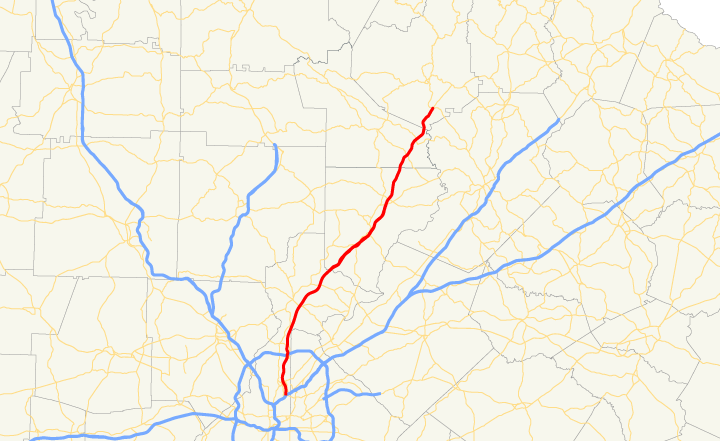
State Route 400

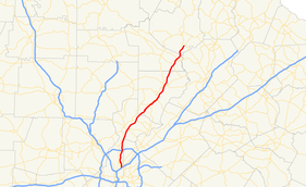
Route information Length: 53.75 mi[1][dead link] (86.50 km) Existed: 1971, 1993 – present Major junctions South end:  I-85 in Buckhead
 I-285 in Sandy Springs
North end: 

 US 19 / SR 60 / SR 115 in Dahlonega
Highway system Georgia State Routes
Former SR←  SR 388
SR 401  →
→Georgia State Route 400 (Georgia 400, SR 400) is a highway in the U.S. state of Georgia, concurrent with U.S. Route 19 (US 19) from exit 4B until its terminus just south of Dahlonega. ST 400 goes from Atlanta, at Interstate 85 (I-85), to Buckhead, Sandy Springs, Roswell, Alpharetta, Cumming, Dawson County, and Dahlonega. Like the Interstate Highways, it is a limited-access road (with exit ramps instead of intersections), but unlike the interstates (which were renumbered by the GDOT in 2000), the exit numbers do not indicate mileage: they still go up sequentially one-by-one. Once ST 400 passes exit 17 (SR 306), it changes from a limited-access expressway into an at-grade divided highway with traffic lights, but still with a high speed limit of 65 miles per hour (105 km/h) and ends at the J.B. Jones Intersection at SR 60 in Lumpkin County.
Between I-85 and I-285, SR 400 is designated "T. Harvey Mathis Parkway"; upon reaching the Perimeter (I-285) and beyond, the highway is designated "Turner McDonald Parkway". SR 400 is known locally as the "Georgia Autobahn", the "North Georgia Autobahn", or the "Alpharetta Autobahn" due to the prevalence of speeding.
Contents
Route description
Georgia State Route 400 begins at Interstate 85 just north of Downtown Atlanta and starts as a toll road through Buckhead. At Interstate 285, the road becomes a free road, heading north into the northern Atlanta suburbs. The freeway section ends at SR 306 and SR 400 continues as a surface road until reaching its end at US 19/SR 60/SR 115.
History
Original portion (I-285 to Georgia 306)
Planning for Georgia 400 began in 1954.[2] The initial section north of I-285 was officially dedicated on May 24, 1971[3] and subsequent additions to the north opened in stages through 1981. The road was subsequently widened in 1989 from its original four-lane configuration to eight lanes between I-285 and Holcomb Bridge Road. The widening projects were necessitated by the massive growth that Georgia 400 brought to northern Fulton and southern Forsyth counties.
In December 2005, the Georgia Department of Transportation began widening the section from Holcomb Bridge Road to Windward Parkway from three to four lanes in the northbound direction and from two to four lanes from Windward Parkway to McFarland Parkway. Southbound, the highway is being widened to four lanes between McFarland Parkway and Holcomb Bridge Road. In addition, metal noise barrier walls and a concrete divider in the median were also added.
As of 2010[update], a half-diamond interchange is being added on the north side of Hammond Drive, allowing southbound exits and northbound entrances.
Georgia 400 extension (I-85 to I-285)
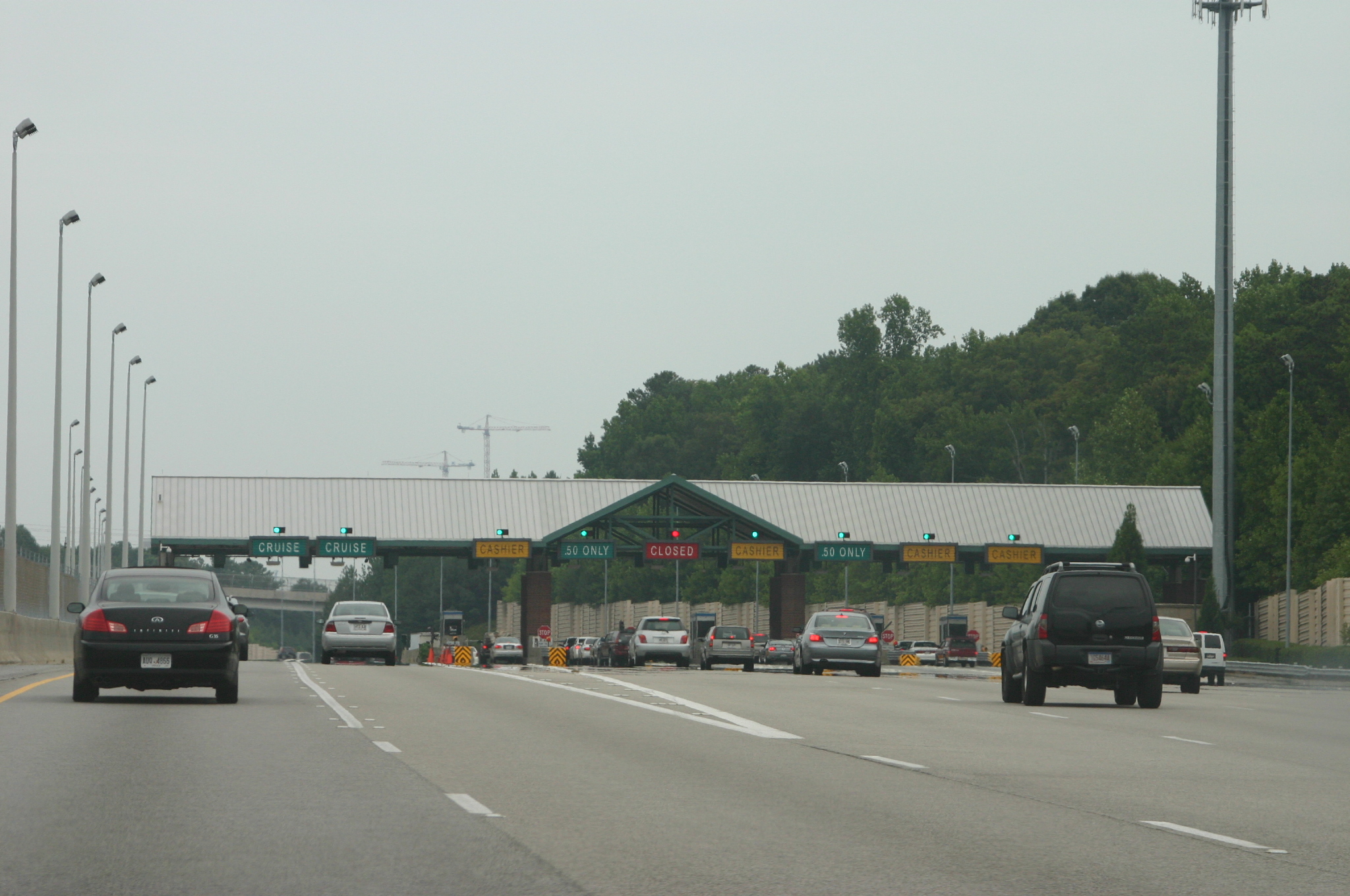
 Toll booth on Georgia 400 on the southbound side
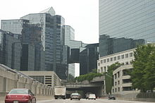 Passing under Buckhead on GA 400 Southbound
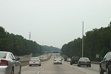 Southbound lanes GA 400 north of Pitts Road overpass
The southern section of Georgia 400 (from I-285 to I-85) was the last section to be constructed. It was the only active toll road in Georgia, after the Torras Causeway toll between Brunswick and St. Simons Island on the southeastern Georgia coast was removed in 2003,[4] until the high occupancy toll Express Lanes opened on I-85 in 2011. The GA 400 toll was to expire in 2011 after 20 years. However, Sonny Perdue and members of the state's road and tollway authority voted on September 24, 2010 to keep the tolls on 400 until 2020. The 10-year extension will fund 11 new projects on the highway. [1]
Freeway revolt
Main article: Freeway revolt in AtlantaAt one time, Georgia 400 was to connect to Interstate 675 in southeast DeKalb county; however, residents in Intown Atlanta neighborhoods did not want the highway to cut through their neighborhoods, and a freeway revolt ensued, ending when Jimmy Carter had the plan terminated while he was governor of Georgia. This freeway was to be known as Interstate 475 (a number now used for the Macon bypass), a parallel route to the Downtown Connector which is just a few miles or kilometers further west through downtown and midtown. The point where this road would have had its interchange with the also-doomed Interstate 485 (now Freedom Parkway and Georgia 10 to Stone Mountain Expressway) is now the site of the Jimmy Carter Presidential Library. A later routing of I-485 would have had that number running from the Downtown Connector (I-75/85), west to the current library, then up what is now 400.
Nonetheless, the northern portion of the inside-the-Perimeter route remained alive, and after lawsuits by residents that spent numerous years in court, GDOT was able to force the extension through Buckhead. Dozens of homes were taken through eminent domain or the threat of it, and the highway was built right though the middle of formerly-secluded and forested neighborhoods. Many remaining residents now live on dead end streets with significant noise pollution or unsightly metal barrier walls.[citation needed]
The road opened to traffic on August 1, 1993, after three years of construction. Existing exits were renumbered up by four to accommodate the extension, which has a single toll plaza in the middle of its length. Contrary to public belief, the bonds that funded the construction of Georgia 400 south of I-285 will not be paid off until 2011. There is also currently no direct access from Georgia 400 southbound to I-85 northbound or vice versa, except by an indirect route via Sidney Marcus Boulevard. In addition, the North Line for Atlanta's MARTA system was constructed in the median from the Glenridge Connector to south of Lenox Road, and was opened on June 8, 1996.
The Georgia 400 toll plaza, operated by the State Road and Tollway Authority (SRTA), collects 50-cent tolls in both the northbound and southbound directions. Each direction has two open-road toll lanes, which collect tolls at highway speeds using the Georgia Peach Pass electronic tag (formerly "Cruise Card"), and seven gated toll lanes which accept cash. The toll facility handles a total of approximately 120,000 vehicles per day. About 37% of transactions are paid via Peach Pass. The same technology is also used by SunPass in Florida, TxTag in Texas, and PikePass in Oklahoma; however, none of these has an agreement to accept the tags of the others.
In March 2009, local TV news reports brought up an issue regarding tolls on the road, since SRTA reported that enough money has been collected to pay the bonds used to construct the road (though prepayment prior to 2011 is prohibited). However, despite promises that the toll would be removed once the road was paid for, the tolls continue to be collected. The road costs two million dollars per year just to maintain (plus occasional repaving), and it would cost several million more for the demolition of the toll plaza. One solution would be to simply close the toll plaza, allowing drivers to pass through without paying. If this were to occur, the state would have to raise money through other resources for new road projects, such as the reconstruction of the tollway's northern interchange at I-285, expected to cost two billion dollars.
A revival of the connection to I-675 was proposed in 2009. A tunnel would go under East Atlanta and other neighborhoods of Atlanta on the DeKalb side, south to I-20. A surface road would then go south to 675. Exhaust fumes and particulate air pollution would be vented into the air over the neighborhoods. The project would be a public/private initiative.
Tolls
The toll plaza is located north of Lenox Road (Exit 2). Tolls are collected in both directions. The toll is 50 cents for a 2-axle vehicle, $1.50 for 3 axles, plus 50 cents for each additional axle. Tolls are not collected on ramps.
Major intersections
County Location Mile Exit Destinations Notes Fulton Atlanta 0.0 I-85 south – Downtown Atlanta, Atlanta AirportSouthern terminus; southbound exit and northbound entrance 0.6 1 Sidney Marcus Boulevard – To I-85 northSouthbound exit and northbound entrance 2.8 2  SR 141 Conn. (Lenox Road)
Single-point urban interchange Toll plaza Sandy Springs 6.6 3 Glenridge Perimeter Connector Formerly SR 407 Loop; northbound use Exit 4A (unnumbered exit from 4A's collector-distributor lanes) 6.8 4A I-285 east – Greenville, AugustaSouthbound entrance ramp is a left merge 6.9 4B I-285 west / US 19 south – Marietta, Chattanooga, BirminghamUS 19 joins northbound and leaves southbound; northbound entrance ramp is a left merge 7.4 4C Hammond Drive – Dunwoody, Sandy Springs southbound exit and northbound entrance only 8.4 5 Abernathy Road – Dunwoody, Sandy Springs Northbound exit split into 5A (Dunwoody, east) and 5B (Sandy Springs, west) 10.0 5C North Springs MARTA station Southbound exit and northbound entrance only 12.0 6 Northridge Road Roswell 15.0 7  SR 140 (Holcomb Bridge Road) – Roswell, Norcross
Peachtree Corners; Northbound exit split into 7A (Norcross) and 7B (Roswell) Alpharetta 16.4 8 Mansell Road North Point Mall 18.3 9 Haynes Bridge Road North Point Mall 19.6 10  SR 120 (Old Milton Parkway) – Alpharetta
21.0 11 Windward Parkway Forsyth 23.8 12 McFarland Parkway Northbound exit split into 12A (east) and 12B (west) 28.0 13  SR 141 (Peachtree Parkway) – Cumming, Norcross
Johns Creek, Peachtree Corners 30.8 14  SR 20 – Cumming, Sugar Hill, Buford
Lake Lanier Islands; northbound exit split into separate east- and westbound exit ramps Cumming 32.8 15 Bald Ridge Marina Road Bald Ridge Marina, Cumming Fairgrounds 34.7 16 Pilgrim Mill Road Lake Sidney Lanier 36.3 17  SR 306 (Keith Bridge Road) – Cumming, Gainesville
Freeway ends Dawson Dawsonville  SR 53
SR 53 SR 136
Lumpkin 53.7 US 19 / SR 60 / SR 115Northern terminus of 400 just after Chestatee River bridges, U.S. 19 continues northbound via SR 60 to the NW, street continues straight NE as Long Branch Road to SR 52 1.000 mi = 1.609 km; 1.000 km = 0.621 mi
Concurrency terminus • Closed/Former • Incomplete access • UnopenedReferences
- ^ 2002 Georgia Department of Transportation 444 Report
- ^ City of Roswell, Georgia, Comprehensive Plan 2025: Chapter 6 Historic Preservation Element, November 7, 2005, p.172
- ^ Roswell, A Pictorial History, Roswell Historical Society, Darlene M. Walsh (Editor), 2nd Edition, 1994, p.150, ISBN 0-9615854-2-0
- ^ Governor's Press Release on Torras Causeway Toll Decommissioning
External links
- State Road and Tollway Authority homepage
- Near real-time traffic image of SR 400 South of Abernathy Rd
- Near real-time traffic image of SR 400 near Spalding Dr
- Near real-time traffic image of SR 400 south of Holcomb Br Rd
Major Roads in Metro Atlanta Interstates and Freeways Interstate 75 (Northwest Expressway/Southeast Expressway) • Downtown Connector • Interstate 20 (R.D. Abernathy Freeway/West Expressway/East Expressway • Interstate 85 (Northeast Expressway/Southwest Expressway) • The Perimeter • Stone Mountain Freeway • Interstate 575 • Georgia 400 • University Parkway • Interstate 675 • Freedom Parkway • Buford Highway/Old 85 • Lanier Parkway • Langford Parkway • Ronald Reagan Parkway • South Fulton Parkway • Peachtree Industrial Boulevard
Major Throughfares Peachtree Street/Peachtree Road • Peachtree Boulevard/Peachtree Industrial Boulevard/Peachtree Parkway • Roswell Road • Ponce de Leon Avenue • North Avenue • D.L. Hollowell Parkway • Cobb Parkway • Metropolitan Parkway • Memorial Drive • Piedmont Avenue/Piedmont Road • West Paces Ferry Road • Buford Highway • Lawrenceville Highway • Spalding Drive • Sugarloaf Parkway
Unbuilt Expressways See also Freeway revolts in AtlantaCategories:- State highways in Georgia (U.S. state)
- Toll roads in Georgia (U.S. state)
- Transportation in Fulton County, Georgia
- Transportation in Forsyth County, Georgia
- Transportation in Dawson County, Georgia
- Transportation in Lumpkin County, Georgia


Wikimedia Foundation. 2010.