- Lethbridge Viaduct
Infobox_Bridge
bridge_name=High Level Bridge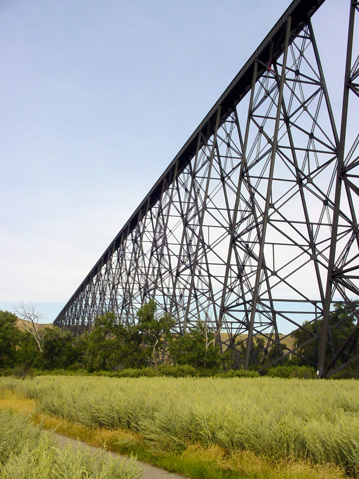
caption=
official_name=Lethbridge Viaduct
carries=Railway
crosses=Oldman River
locale=Lethbridge
maint=Canadian Pacific Railway
id=
design=
mainspan=
length=1,624 m
width=32.6 m
height=95.7 m
load=
clearance=
below=
traffic=
open=August 1909
closed=
toll=
troll=
map_cue=
map_
map_text=
map_width=
coordinates= coord|49|41|50.89|N|112|52|7.32|W|type:landmark
lat=
long=The Lethbridge Viaduct, commonly known as the High Level Bridge, was constructed between 1907–1909 at
Lethbridge ,Alberta ,Canada at a cost of $1,334,525.Overview
This massive steel
trestle over theOldman River was designed by theCanadian Pacific Railway 'sbridge department in Montreal. The field work was directed by CPR's Assistant Chief Engineer J. E. Schwitzer. The steel work was manufactured by the Canadian Bridge Company of Walkerville,Ontario . A 100 man gang worked on the erection of the steel. Although there were some initial problems with settlement, the bridge has proved to be an enduring engineering work and is still in use today.This bridge is the largest railway structure in Canada.Fact|date=March 2008 It was built as part of a major diversion of the
Crowsnest Pass route between Lethbridge and Fort Macleod. The river crossing was previously over a wooden trestle measuring unit m|894|0|lk=on long and unit m|20|0 high; an impressive structure in its own right.History
The old approach was over steep grades that hampered operations. In addition, extensive cuts and many other bridges were needed to cross various creeks and coulees. Past the St Mary's River crossing, several large cuts had been required. Large bridges were also required, including a unit m|275|0 trestle with a unit m|61|0 span west of the
St. Mary River , a unit m|183|0 trestle at Eight-Mile Coulee and another of unit m|274|0 in length near Eight-Mile Coulee. At Sixteen-Mile Coulee there was a unit m|244|0 trestle, unit m|40.5|1 high with a unit m|61|0 truss span over the creek. The trestles on the original line out of Lethbridge totalled unit km|4.5|1.Although the original route accomplished its purpose in allowing the CPR to rapidly complete the railway, it turned out to be expensive to operate. The original bridges were designed to last only about 10 years. The CPR decided, in 1905 to construct a completely new route on a better gradient to bypass the original line. The new line was built to the north of theOldman River . It required two bridges, one just west of Lethbridge—the "High Level Bridge"—over the Oldman River and another large bridge over the Oldman River again west of Monarch. This route eliminated many curves and reduced the grade from 1.2 percent to only 0.4 percent. It also saved unit km|8.5|2 of track.Construction began in the summer of 1907. Clearing and grading the site, construction of piers, and placement of the footings progressed while the steelwork was being prefabricated. Raising the steelwork began in mid-August 1908. Once the steelwork reached track level at the Lethbridge end, it was possible to begin using a huge travelling crane, pictured at left, called an "erection traveller". The traveller was built on site at a cost of $100,000. It was used to lower the steel beams and girders into place. The last girder was placed in June 1909 and riveting was completed in August 1909. Transport of the steel to the site required 645 railway cars while another 40 were needed to bring in equipment.
pecifications
*Length: unit m|1623.86|3
*Height: unit m|95.7|1 above river bed
*Materials: 12,400 tons of steel
*Deck spans and lengths:
**44 plate girder spans each of unit m|20.4|2
**22 plate girder spans each of unit m|30.15|2
** one riveted lattice-truss of unit m|32.6|2
*Rigid braced steel towers: total of 33The second bridge over the Oldman River, near Monarch, is unit m|576|0 long and unit m|45.7|0 high.
External links
* [http://www.lethbridge.ca/NR/rdonlyres/CEDD645A-0834-4950-9633-ABBDAD4C1347/7141/bridge.wmv Video clip of historic photos]
ee also
*
List of bridges
Wikimedia Foundation. 2010.